|
 |
 |
Primary Products - Overview Maps & Evolution Overview:
|
|
|
|
|
|
|
|
|
|
|
|
|
|
|
|
|
|
|
|
 |
|
|
|
|
|
|
|
|
|
|
|
|
|
|
|
Tile 6
Tile 6 coordinates:
24°36'16.14" N. 81°41'35.20" W.
24°39'30.32" N. 81°25'29.30" W.
24°32'15.45" N. 81°23'47.41" W.
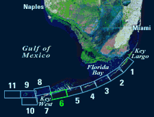
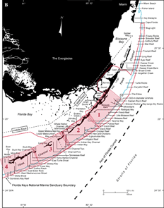
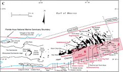
24°29'01.42" N. 81°39'44.31" W. | Major Geographic Sites: Onshore, Tile 6 (lower Keys) includes the southernmost parts of the Saddlebunch Keys (Fig. 86A, 86C; 86B shows the middle and upper Keys). West Washerwoman constitutes a prominent mid-shelf cluster of patch reefs in the middle of Hawk Channel. Offshore reefs include Looe Key Reef, American, Maryland, and Pelican Shoals, and Eastern Sambo.
Three fully protected no-take zones have been established at Looe Key Reef (see Marine Sanctuaries). One area is a Sanctuary Preservation Area and another a Research Only Area. Both lie within the boundary of an Existing Management Area. Reefs at Eastern Sambo have been designated a Research Only Area.
| Figure 86. (A) Landsat satellite image of south Florida shows individual tile boundaries (blue rectangles) of this regional study in the Florida Keys National Marine Sanctuary. Tile 6 is highlighted. (B) Index map shows locations of named reefs and shoals in the upper Keys and northeastern middle Keys, delineated by dashed lines. Red rectangles show geographic boundaries of Tiles 1, 2, 3, and 4. (C) Contiguous part of index map shows westernmost part of middle Keys and the lower Keys (dashed lines). Red rectangles show geographic boundaries of Tiles 5 and 6, with Tile 6 and its geographic sites highlighted. Note the boundary of Looe Key National Marine Sanctuary (parallelogram at shelf margin) lies within the boundary of the Florida Keys National Marine Sanctuary (red line). Shelf-margin contour is in blue. Contours are in meters. [larger version] |
|
|
|
|
continue to: Sector-Specific Studies
|