FISC - St. Petersburg
|
Organization of Report
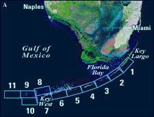
Tile-by-Tile Analysis: To examine more closely specific aspects of the geologic record and modern environment summarized in the opening overview, the elongate area of the Florida reef tract was divided into 11 geographic sectors, referred to as tiles (Fig. 20A). For discussion purposes, where little research has been done in two adjacent sectors, those areas are considered in the tile-by-tile analysis as one (i.e., Tile 7/8 and Tile 9/10).
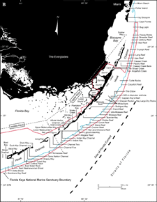
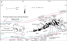
The overview maps for bedrock surface, sediment thickness, benthic ecosystems, and sedimentary grains are intended to provide a regional perspective of broad geologic trends. The importance, quantity, and close spacing of details on the benthic ecosystems map required that it be split into enlarged map tiles for close inspection. The map tiles are at a scale of 1:24,000 and correspond to the 11 geographic sectors. The scale was based on the Lidz et al. (1997a) published map for the area off Key Largo. In the tile-by-tile analysis, discussion of research in most cases is organized under three headings: Geography, Sector-Specific Studies, and Geologic Highlights (see Table of Contents). The Geography section includes latitudinal and longitudinal coordinates (degrees, minutes, seconds) of the geographic sector and its corresponding benthic ecosystems map, and a listing of major onshore and offshore geographic sites within that sector. The Sector-Specific Studies section examines research conducted within that geographic area of the reef tract. The Geologic Highlights section addresses the individual geographic sites. Exceptions to the three-heading format are in Tile 7/8 and Tile 11, where sector-specific studies are more suitable to discussion of geologic highlights. Tile 7/8 also encompasses the westernmost end of the Florida Keys chain and its nearby reefs. In keeping with the geographic end-of-the-keys theme, the Tile 7/8 discussion has five additional headings that address subjects pertinent to the regional area of the keys and their reefs as a whole: Natural Stressors, Margin Evolution, Flooding the Florida Shelf, Addendum, and Ephemeral Islands and Lighthouses. The Addendum section addresses the new aspects of the geologic record that were recognized after completion of this report. The Summary page links studies on modern reefs to the rock record and returns to the condition—and fate—of the present, declining, reef system. |

![]() U.S. Department of the Interior |
U.S. Geological Survey
U.S. Department of the Interior |
U.S. Geological Survey
URL: [disc] /pubs/pp/2007/1751/professional-paper/organization.html
Page Contact Information: Feedback
Page Last Modified: December 01, 2016 @ 04:12 PM (JSS)