|
 |
 |
Primary Products - Overview Maps & Evolution Overview:
|
|
|
|
|
|
|
|
|
|
|
|
|
|
|
|
|
|
|
|
 |
|
|
|
|
|
|
|
|
|
|
|
|
|
|
|
Tile 2
Tile 2 coordinates:
24°54'25.60" N. 80°42'53.23" W.
25°03'00.38" N. 80°29'34.02" W.
24°57'01.47" N. 80°24'52.12" W.
24°48'24.89" N. 80°38'09.90" W. |
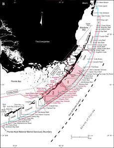
Major Geographic Sites: Tile 2 (upper Keys) includes Plantation Key, Snake Creek, Whale Harbor Channel, Windley Key, Islamorada, Upper Matecumbe Key, Lignumvitae Key, Indian Key Channel, Indian Key, Lower Matecumbe Key, and nearshore Tavernier Key (Fig. 42A, 42B). Shelf features include Hen and Chickens patch reef in Hawk Channel. Offshore reefs include Conch and adjacent Little Conch, Davis, Crocker, and Alligator Reefs.
Sanctuary Preservation Areas have been established at Conch and Davis Reefs, Hen and Chickens patch reef, Cheeca Rocks (located just off Islamorada due west of Crocker Reef), and at Alligator Reef (see Marine Sanctuaries). Conch Reef is also a Research Only Area.
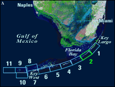 |
| Figure 42. (A) Landsat satellite image of south Florida shows individual tile boundaries (blue rectangles) of this regional study in the Florida Keys National Marine Sanctuary. Tile 2 is highlighted. (B) Index map shows locations of named reefs and shoals in the upper Keys and northeastern middle Keys, delineated by dashed lines. Red rectangles show geographic boundaries of Tiles 1 and 2, with Tile 2 and its geographic sites highlighted. Sanctuary boundary is in red; shelf-margin contour (blue) is in meters. [larger version] |
|
 |
continue to: Sector-Specific Studies
|


