USGS - science for a changing world

FISC - St. Petersburg

Coastal & Marine Geology Program > Center for Coastal & Watershed Studies > Professional Paper 1751

Systematic Mapping of Bedrock and Habitats along the Florida Reef Tract—Central Key Largo to Halfmoon Shoal (Gulf of Mexico)

USGS Professional Paper 1751

by Barbara H. Lidz, Christopher D. Reich, and Eugene A. Shinn

Introduction:
Table of Contents
Project Overview
Project Objective
Geologic Setting
Primary Datasets
Primary Products - Overview Maps & Evolution Overview:
Bedrock Surface map.
Introduction
Depth to Pleistocene Bedrock Surface
Reef & Sediment Thickness
Benthic Ecosystems & Environments
Sedimentary Grains in 1989
Summary Illustration Index Map
Evolution Overview
Tile-by-Tile Analysis
Satellite image of the Florida Keys showing location of tiles.
Organization of Report
Tiles: 1, 2, 3, 4,
5, 6, 7/8, 9/10,
11
Summary
Acknowledg-
ments
References
Disclaimer
Related
Publications

Project Overview

Location of study area.
Figure 1. Location of study area. [larger version]

Landsat satellite image of south Florida shows individual tile boundaries (blue rectangles) of this regional study in the Florida Keys National Marine Sanctuary.
Figure 2. Landsat satellite image of south Florida shows individual tile boundaries (blue rectangles) of this regional study in the Florida Keys National Marine Sanctuary. [larger version]
Introduction: The fragile coral reefs of the Florida Keys form the largest living coral reef ecosystem in the continental United States (Fig. 1). Lining the shallow outer shelf approximately 5 to 7 km seaward of the keys (Fig. 2), the reefs have national aesthetic and resource value.

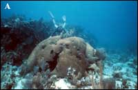
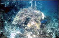
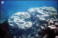
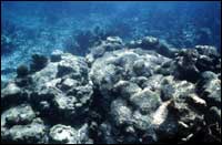
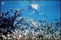
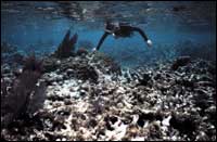
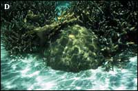
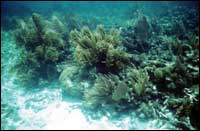
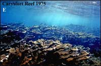
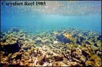
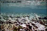
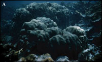
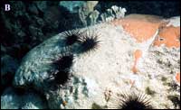
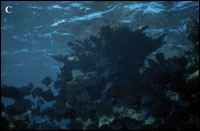
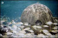
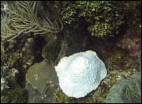
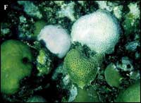
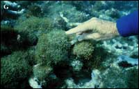
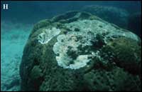
As recently as the 1970s, the coral reefs were the heart of a vibrant ecosystem. Since then, the health of all ecosystem components has declined markedly due to a variety of environmental stressors (e.g., see papers in Jaap et al., 1998; Porter and Porter, 2002; Lang, 2003). Corals are succumbing to bleaching and diseases (Figs. 3A, 3B, 3C, 3D, 4A, 4B, 4C, 4D, 4E, 4F, 4G, and 4H). Species that are the building blocks of solid reef framework are increasingly being replaced by species that do not construct reef framework. Algal proliferation is increasing competition for space and hard surfaces needed by coral larvae for settlement. Decline of the coral reef ecosystem has significant negative implications for economic vitality of the region, ranging from viability of the tourism industry attracted by the aesthetics to commercial fisheries drawn by the resources. At risk of loss are biologic habitats and reef resources, including interconnected habitats for endangered species in shoreline mangroves, productive nearshore marine and wetland nurseries, and economic offshore fisheries.

What are the reasons for this decline? Is it due to natural change, or are human activities (recreational diving, ship groundings, farmland runoff, nutrient influx, airborne contaminants, groundwater pollutants) a contributing factor and if so, to what extent and can they be mitigated?

One of the first steps to differentiate between natural change and the effects of human activities is to look at the big picture. In the case of Florida's reefs, mapping various aspects of the reef tract achieves this goal—and answers the question, how did coral reefs respond to past environmental change, before the influence of man? A clear understanding of the geologic and biologic history of a region, any region, is fundamental to:

  • recognizing the cause and effect of what transpired there in the past;
  • establishing current status in order to monitor changes; and
  • assessing how management and conservation of existing natural resources within that region can effectively be implemented (e.g., Table 1 in the case of the Florida reef tract).

Table 1. Areas in which geologic map information contributes to ecosystem stewardship.Table 1. Ecosystem stewardship involves knowledge of geologic and biologic science to implement plans for ecosystem preservation and human safety. [larger version]

In 1997, the U.S. Geological Survey's (USGS) Coastal and Marine Geology Program undertook a comprehensive 7-year-long mission to consolidate, synthesize, and map new (1997) and existing geologic and biologic information into a digitized regional database and one-volume reference source on the geologic history of the Florida Keys reef tract (this report). The project was conducted in cooperation with the National Oceanic and Atmospheric Administration's (NOAA) National Marine Sanctuary Program. The purpose was to examine the natural evolution and demise of several coral reef ecosystems over the past 325,000 years, with an eye toward gaining a better understanding of the cause of the reef decline observed today. Scientific data and datasets presented in this report are intended for use by others in ongoing efforts to delineate which components of reef decline in the Florida Keys may be natural and which may be a result of human activities.

Colpophyllia natans in 1988
Colpophyllia natans in 1998
Colpophyllia natans
at Grecian Rocks
1988 and 1998
Montastrea annularis in 1986
Montastrea annularis in 2001
Montastrea annularis
at Carysfort Reef
1986 and 2001
corals in 1971
corals in 1988
Montastrea franksi under diver, Acropora palmata at left and back right, and A. cervicornis in foreground at Grecian Rocks
1971 and 1988
Montastrea franksi in 1971
Montastrea franksi in 1999
Montastrea franksi
at Grecian Rocks
1971 and 1999


Carysfort Reef 1975 Carysfort Reef
1975, 1985, and 1995

Healthy elkhorn coral (Acropora palmata). For scale, note striped sergeant majors (Abudefduf saxatalis) in center (14-15 cm). Surface-water wavelets are visible above the shallow reef.
Carysfort Reef 1985 Same view shows widespread physical damage to coral and absence of fish. Cause of damage is unknown but could be boat groundings or storms. Parts of live coral colony are visible around photo edges and at right center.
The shallow reef is reflected on the water surface.
Carysfort Reef 1995 Same view shows complete death and destruction of coral and no fish. Photos courtesy of Phillip Dustan, College of Charleston, Charleston, SC.
Figure 3. (A-D) Photo pairs show vitality of head and branching corals in the recent past (top row) and their present state of decline (bottom row) in the Florida Keys. Each pair is of the same corals at two different points in time. Note coral rubble and presence of macroalgae, sea whips, and sea fans in the later photos. Photos in (C) are from Shinn et al. (2003). (E) Similar degradation of Acropora palmata is present at Carysfort Reef. [larger version]

Healthy Corals
Montastrea annularis Black spiny sea urchin Diadema antillarum grazing a dead area on a species of Siderastrea.
Stand of healthy Acropora palmata. Healthy Colpophyllia natans.
Stressed and Diseased Corals
Bleached Meandrina species. Bleached Siderastrea and Diploria species.
Typical overgrowth of turf algae on coral. White-band disease on a colony of Montastrea annularis.
Figure 4. Photos show other examples of healthy corals (A-D) and stressed or diseased corals (E-H). (A) Reef-framework builders Montastrea annularis (massive head coral, foreground) and Acropora palmata (platy moosehorn or elkhorn coral, background). (B) Black spiny sea urchin Diadema antillarum grazing a dead area on a species of Siderastrea before 1983. Though the coral is essentially dead, browsing urchins in a healthy reef keep the dead surface (foreground) free of algae. Live coral polyps are at upper right. Blades of live hydrocoral Millepora complanata are in the background. The Diadema population suffered a Caribbean-wide die-off in 1983-1984 from an unknown cause (Lessios et al., 1984) and from which it has not recovered. (C) Stand of healthy Acropora palmata. (D) Healthy Colpophyllia natans. (E) Bleached Meandrina species. A coral is said to bleach when it expels the symbiotic algae needed for photosynthesis, color, and to build its skeleton. Bleaching is a sign of stress, not a disease. If conditions that caused bleaching return to normal fairly rapidly, the coral will regain its symbiotic algae. If conditions do not allow bleaching to reverse, coral mortality may result. (F) Bleached Siderastrea (left) and Diploria species (right). (G) Typical overgrowth of turf algae on coral rubble in 1992 in Florida, nine years after demise of Diadema. Fleshy algal mats retard establishment of coral larvae. (H) White-band disease on a colony of Montastrea annularis. This and other types of band disease can destroy a 200-year-old coral in a single summer. [larger version]

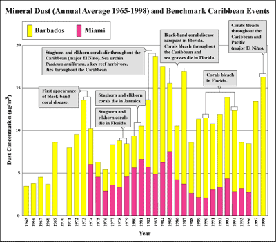
Beyond scientific baseline datasets, this report also incorporates environmental, social, and historical aspects of the Florida Keys, including the impact of exploratory oil wells on benthic habitats off Florida. Beginning in the 1940s and ending in 1962, 14 exploratory oil wells were drilled in the Florida Keys. Five are examined in this report. Three were drilled on the reef tract southwest of the Marquesas Keys in the Gulf of Mexico. About 30 were drilled in deep water off the Gulf Coast of Florida. Two of these are also examined. These studies are also important in light of the recent renewed interest in the 1990s and 2000s in drilling for oil and gas in the Gulf of Mexico.

New information on the significance of a nearshore rock ledge that borders the seaward side of every island in the Florida Keys has recently come to light. All evidence on hand points to ongoing island erosion that began about 4,000 years ago.

Landmark studies in the Florida Keys (e.g., Ginsburg, 1956; Ball, 1967; Hoffmeister et al., 1967; Hoffmeister and Multer, 1968; Hoffmeister, 1974; Enos and Perkins, 1977; Jaap, 1984; Harrison and Coniglio, 1985) previously examined the geologic/biologic record but from perspectives different than those in this report. Other map series have shown distribution of habitats on the reefs (Marszalek, 1977; Multer, 1993; FMRI 2000), but those maps are less extensive than the benthic map in this report and lack explanation of the geologic and sea-level history. Where appropriate, this report incorporates the significant contributions these and numerous other researchers have made to knowledge of the geologic record of the reef tract, as well as important results of more recent studies on shelf-edge facies (the aspect, appearance, and characteristics of a rock unit; Multer et al., 2002) and effects of African dust on reefs (e.g., Shinn et al., 2000; Griffin et al., 2001; Garrison et al., 2003; Fig. 5; USGS Open-File Report 2001–246; USGS Open-File Report 2003028).

Average African dust concentrations measured in Miami and Barbados
Figure 5. Average African dust concentrations measured in Miami and Barbados (Windward Islands) and major events that occurred in reef organisms in the Florida-Caribbean region. Are they related? Data for 1965 to 1986 are from Prospero and Nees (1986). Data from 1987 to 1996 are courtesy of J.M. Prospero. African dust events can readily be observed on the Internet from NASA SeaWiFS and TOMS satellite data (http://coastal.er.usgs.gov/african_dust/ and http://seawifs.gsfc.nasa.gov/SEAWIFS.html). A short video, "The Effects of Globally Transported African and Asian Dust on Coral Reef and Human Health," can be viewed at http://coastal.er.usgs.gov/african_dust/documentary/. [larger version]

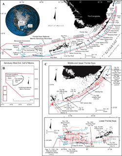
By no means is this report a review of every study done in the Florida Keys. The focus is on an area within the Florida Keys National Marine Sanctuary for which contiguous seismic, aerial-photographic, and sedimentary-grain data are now available (Fig. 6A, 6B, 6C). The area includes the keys seaward ~5 to 7 km to a margin-wide upper-slope terrace (30 to 40 m deep) and extends from a shelf-edge reef known as The Elbow (off central Key Largo) to Halfmoon Shoal (west of The Quicksands in the Gulf of Mexico).

(A) Index map of south Florida and the Florida Keys. (B) Index map of west end of the Sanctuary shows the Tortugas Ecological Reserve North and South areas that became part of the Florida Keys National Marine Sanctuary in July 2001. (C) Index map shows location of U.S. Geological Survey seismic tracklines and those portions selected for illustration with their figure numbers. Figure 6. (A) Index map of south Florida and the Florida Keys (modified from Lidz et al., 2003). Dashed lines delineate lower, middle, and upper Keys. Note major tidal passes are in the middle Keys. The 30-m depth contour (blue line) marks the shelf margin, which lies within the Florida Keys National Marine Sanctuary boundary (red line). (B) Index map of west end of the Sanctuary shows the Tortugas Ecological Reserve North and South areas that became part of the FKNMS in July 2001. The FKNMS now has two boundaries. (C) Index map shows location of USGS seismic tracklines (red) and those portions selected (bold black) for illustration with their figure numbers. Shelf margin is in blue. A red "dot" of heavy seismic coverage at the northeast end denotes location of a sinkhole (Shinn et al., 1996). Contours are in meters. [larger version]

The fundamental principle underpinning the study of geologic processes and the geologic record is, "The present is the key to the past." Following this tenet, the report concludes by evaluating the importance of studies on modern reefs as they relate to the rock record. Through laboratory experiments, we examined how modern marine sediments from the Florida Keys become consolidated and compacted into limestone-like 'rock.' The 'rocks' were not limestone only because they lacked natural mineral cements. Compaction produced microscopic features similar to those observed in actual limestone and reduced intra-particle porosity, as occurs naturally in sediments compressed by overburden (overlying layers) through time. Through coring, we investigated how ancient reefs consisting of non-coralline marine-carbonate materials had developed. The reef buildups are now uplifted limestone reefs in mountains of New Mexico. These studies are two of many that apply what we see happening today to what might have happened in the past.

Coastal & Marine Geology Program > Center for Coastal & Watershed Studies > Professional Paper 1751

Accessibility FOIA Privacy Policies and Notices

Take Pride in America logo USA.gov logo U.S. Department of the Interior | U.S. Geological Survey
URL: [disc] /pubs/pp/2007/1751/professional-paper/project-overview.html
Page Contact Information: Feedback
Page Last Modified: December 01, 2016 @ 04:12 PM (JSS)