USGS - science for a changing world

FISC - St. Petersburg

Coastal & Marine Geology Program > Center for Coastal & Watershed Studies > Professional Paper 1751

Systematic Mapping of Bedrock and Habitats along the Florida Reef Tract—Central Key Largo to Halfmoon Shoal (Gulf of Mexico)

USGS Professional Paper 1751

by Barbara H. Lidz, Christopher D. Reich, and Eugene A. Shinn

Introduction:
Table of Contents
Project Overview
Project Objective
Geologic Setting
Primary Datasets
Primary Products - Overview Maps & Evolution Overview:
Bedrock Surface map.
Introduction
Depth to Pleistocene Bedrock Surface
Reef & Sediment Thickness
Benthic Ecosystems & Environments
Sedimentary Grains in 1989
Summary Illustration Index Map
Evolution Overview
Tile-by-Tile Analysis
Satellite image of the Florida Keys showing location of tiles.
Organization of Report
Tiles: 1, 2, 3, 4,
5, 6, 7/8, 9/10,
11
Summary
Acknowledg-
ments
References
Disclaimer
Related
Publications

Primary Datasets

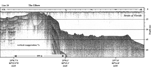
Introduction: Three primary types of data sources were used in this regional project: seismic profiles (Figs. 6C, 10), aerial photomosaics (Lidz et al., 2003), and thin sections of surface sediments (e.g., Lidz and Hallock, 2000). Radioisotope dates on corals, soilstone crust, and mangrove peat recovered in cores aided interpretations of how and when features accumulated that are now visible in the seismic profiles and photos (e.g., Shinn et al., 1977a; Robbin, 1981, 1984). All datasets except thin-section results were correlated with sea-level fluctuation data from the reef tract and elsewhere (e.g., Toscano and Lundberg, 1999; Chappell and Shackleton, 1986).

Example of the high-quality seismic profiles (1997) used in this project.
Figure 10. Example of the high-quality seismic profiles (1997) used in this project. This profile crossed the shelf margin and upper-slope terrace at The Elbow (upper Keys, Fig. 6C, Tile 1). Note presence of a backreef trough in the bedrock (deep "W" shape in reflection of bedrock surface under the name of the reef). The trough has been filled with Holocene reefs and sediments and has no topographic expression in the present-day sea floor. Reflections in a seismic record represent a change in acoustic (sound-wave) impedance across contacts between rock layers having different acoustic properties. In other words, seismic reflections indicate the presence of subsurface rock surfaces or stratigraphic horizons within the rock record. In this case, the stratigraphic horizon is the unconformity between Pleistocene and Holocene limestones (see Fig. 7B). Latitude and longitude in degrees and decimal minutes based on GPS coordinates. Hours (military time) below coordinates serve as navigational correlation points along seismic line. (Figure modified from Lidz et al., 2003). [larger version]

Coastal & Marine Geology Program > Center for Coastal & Watershed Studies > Professional Paper 1751

Accessibility FOIA Privacy Policies and Notices

Take Pride in America logo USA.gov logo U.S. Department of the Interior | U.S. Geological Survey
URL: [disc] /pubs/pp/2007/1751/professional-paper/primary-datasets.html
Page Contact Information: Feedback
Page Last Modified: December 01, 2016 @ 04:12 PM (JSS)