USGS - science for a changing world

FISC - St. Petersburg

Coastal & Marine Geology Program > Center for Coastal & Watershed Studies > Professional Paper 1751

Systematic Mapping of Bedrock and Habitats along the Florida Reef Tract—Central Key Largo to Halfmoon Shoal (Gulf of Mexico)

USGS Professional Paper 1751

by Barbara H. Lidz, Christopher D. Reich, and Eugene A. Shinn

Introduction:
Table of Contents
Project Overview
Project Objective
Geologic Setting
Primary Datasets
Primary Products - Overview Maps & Evolution Overview:
Bedrock Surface map.
Introduction
Depth to Pleistocene Bedrock Surface
Reef & Sediment Thickness
Benthic Ecosystems & Environments
Sedimentary Grains in 1989
Summary Illustration Index Map
Evolution Overview
Tile-by-Tile Analysis
Satellite image of the Florida Keys showing location of tiles.
Organization of Report
Tiles: 1, 2, 3, 4,
5, 6, 7/8, 9/10,
11
Summary
Acknowledg-
ments
References
Disclaimer
Related
Publications

Primary Products

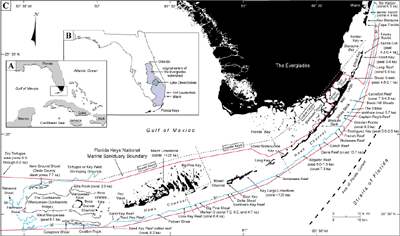
Overview Map—Summary Illustration Index Map: A Summary Illustration index map shows core components of what is known as the South Florida Ecosystem (e.g., McPherson and Halley, 1996; Causey, 2002): the Everglades, Florida and Biscayne Bays, the Florida Keys, and the reef tract, which lies just inside the 30-m depth contour that marks the shelf margin. These core components are linked geologically and hydrologically through porous limestone bedrock and a natural southward flow of ground and surface water. The core components are also linked biologically in that juvenile stages of various marine organisms inhabit different subenvironments within the ecosystem (Ley and McIvor, 2002; Cocheret de la Morinière et al., 2003; Serafy et al., 2003). An excellent sourcebook on past and present status of the many factors, both natural and anthropogenic, that comprise and affect the South Florida Ecosystem is found in Porter and Porter (2002).

Summary Illustration index map: A summary illustration index map (A, B, and C) shows geography in the Florida Keys area.
Summary Illustration index map: A summary illustration index map (A, B, and C) shows geography in the Florida Keys area (modified from Lidz, 2004). Dashed lines indicate natural division of the keys, based on orientation and rock composition, into the lower Keys (oolitic Miami Limestone) and middle and upper Keys (reefal Key Largo Limestone). Age (~125 ka) of the two formations is well established. Holocene reefs lie between the keys and the 30-m contour (blue line), which marks the shelf margin. Red line marks the boundary of the Florida Keys National Marine Sanctuary. Contours are in meters.

(A) Inset shows geographic study area.

Inset (B) shows the location of Fort Lauderdale, where tiered barrier reefs developed offshore ~7 to 6 ka (Lighty, 1977; Lighty et al., 1978, 1982), and the city of Orlando, once the northern boundary of the Everglades watershed (shaded area; e.g., Douglas, 1947). The Everglades watershed today extends from Lake Okeechobee southward.

Primary map (C) shows locations and ages of radiometrically dated materials. Conventional radiocarbon (14C) ages <10 ka are the oldest Holocene dates at the site indicated. The dates shown are uncorrected for variations in production of the 14C isotope used to date the materials and are given in calendar years before present. Two-sigma calibration ranges are given in tables presented in Tile 1. Coral ages show that growth began first to the southwest due to uneven flooding along a westward-sloping shelf (e.g., Perkins, 1977; Lidz et al., 2003). [larger version]

The index map shows the locations and oldest radioisotope ages for Holocene materials dated along the reef tract. The ages have not been corrected for variations in production of the carbon-14 (14C) isotope used to date the materials and are given as abbreviated conventional radiocarbon ages (CRA). Coral ages indicate growth began first in the southwest and later in the northeast, which is consistent with lower bedrock elevation and earlier flooding of the southwestern part of the shelf.

From north to south, the Florida Keys vary in both orientation and rock composition (e.g., Hoffmeister and Multer, 1968). The upper and middle Keys parallel the margin and consist of the Key Largo Limestone (coral reef). The lower Keys, oriented nearly perpendicular to the margin, consist of the Miami Limestone (oolite).

The inset on the index map shows the location of Fort Lauderdale, where tiered barrier reefs developed offshore ~7 to 6 ka (Lighty et al., 1978, 1982), and the city of Orlando, once the northern boundary of the Everglades watershed (shaded area). The Everglades today is less than half this earlier size (Douglas, 1947).

Coastal & Marine Geology Program > Center for Coastal & Watershed Studies > Professional Paper 1751

Accessibility FOIA Privacy Policies and Notices

Take Pride in America logo USA.gov logo U.S. Department of the Interior | U.S. Geological Survey
URL: [disc] /pubs/pp/2007/1751/professional-paper/summary-illustration.html
Page Contact Information: Feedback
Page Last Modified: December 01, 2016 @ 04:13 PM (JSS)