|
 |
 |
Primary Products - Overview Maps & Evolution Overview:
|
|
|
|
|
|
|
|
|
|
|
|
|
|
|
|
|
|
|
|
 |
|
|
|
|
|
|
|
|
|
|
|
|
|
|
|
Tile 4
Tile 4 coordinates:
24°43'08.83" N. 81°10'46.19" W.
24°48'13.38" N. 80°55'23.13" W.
24°41'30.19" N. 80°52'35.36" W.
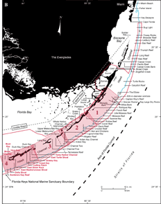
24°36'19.52" N. 81°07'59.14" W. | Major Geographic Sites: Tile 4 (middle Keys) includes Grassy Key, Crawl Key, Vaca Key, Boot Key, and Moser Channel, the widest channel in the Florida Keys (Fig. 68A, 68B). A submerged nearshore feature is East Sister Rock. East Washerwoman Shoal and other discrete groups of patch reefs occur in Hawk Channel. One of those groups is East Turtle Shoal, located south-southwest of Duck Key. A transect of treasure-salvor sand holes crosses sand and seagrass beds east of East Turtle Shoal. Offshore reefs include Coffins Patch, Delta Shoal, and Sombrero Key Reef. Coffins Patch and Sombrero Key Reef are both Sanctuary Preservation Areas (see Marine Sanctuaries).
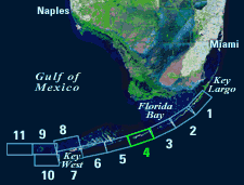 |
| Figure 68. (A) Landsat satellite image of south Florida shows individual tile boundaries (blue rectangles) of this regional study in the Florida Keys National Marine Sanctuary. Tile 4 is highlighted. (B) Index map shows locations of named reefs and shoals in the upper Keys and northeastern middle Keys, delineated by dashed lines. Red rectangles show geographic boundaries of Tiles 1, 2, 3, and 4, with Tile 4 and its geographic sites highlighted. Sanctuary boundary is in red; shelf-margin contour (blue) is in meters. [larger version] |
|
 |
continue to: Sector-Specific Studies
|


