|
 |
 |
Primary Products - Overview Maps & Evolution Overview:
|
|
|
|
|
|
|
|
|
|
|
|
|
|
|
|
|
|
|
|
 |
|
|
|
|
|
|
|
|
|
|
|
|
|
|
|
Tile 11
Tile 11 coordinates:
24°38'16.08" N. 82°30'16.92" W.
24°38'16.08" N. 82°13'18.12" W.
24°30'47.16" N. 82°13'18.12" W.
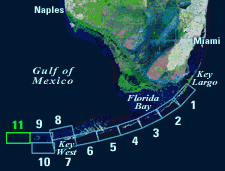
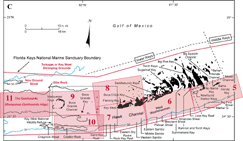
24°30'47.16" N. 82°30'16.92" W. | Major Geographic Sites: Tile 11 (Gulf of Mexico) is centered on an area west of the Marquesas Keys known as The Quicksands (Fig. 132A, 132B, 132C). The sands overlie an elevated bedrock ridge that is informally called the Marquesas-Quicksands ridge (Shinn et al., 1990). The ridge is loosely bounded by Boca Grande Channel to the east (Tile 9), Ellis Rock and New Ground Shoal to the north, and Halfmoon Shoal and an unnamed channel to the west (Fig. 117). Rebecca Shoal lies off the northwest end of the channel. Cosgrove Shoal and Coalbin Rock at the shelf edge separate the ridge and its seaward lagoon (i.e., the westward extension of Hawk Channel, Tile 10) from the Straits of Florida. West of The Quicksands are the two Tortugas Ecological Reserves (TER North and TER South, Fig. 6B) that are now part of the Florida Keys National Marine Sanctuary (see Marine Sanctuaries).
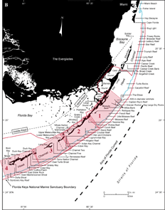
| Figure 132. (A) Landsat satellite image of south Florida shows individual tile boundaries (blue rectangles) of this regional study in the Florida Keys National Marine Sanctuary. Tile 11 is highlighted. (B) Index map shows locations of named reefs and shoals in the upper Keys and northeastern middle Keys, delineated by dashed lines. Red rectangles show geographic boundaries of Tiles 1, 2, 3, and 4. (C) Contiguous southwestern part of index map shows named reefs and shoals in the westernmost middle Keys and lower Keys (dashed lines). Red rectangles show geographic boundaries of Tiles 5, 6, 7, 8, 9, 10, and 11, with Tile 11 and nearby geographic sites discussed highlighted. Halfmoon and Rebecca Shoals and an unnamed channel lie off the left side of the map. Black-dot rectangle shows area of Key West National Wildlife Refuge. Sanctuary boundary is in red; shelf-margin contour is in blue. Contours are in meters. [larger version] |
|
|
|
|
continue to: Geologic Highlights
|