FISC - St. Petersburg
|
Project Overview
Mapping the Florida Reef Tract: This report evaluates the distribution (location) and historic vitality (thickness) of reefs and sediments of the present coral reef ecosystem by mapping four basic components from central Key Largo to the western extent of The Quicksands:
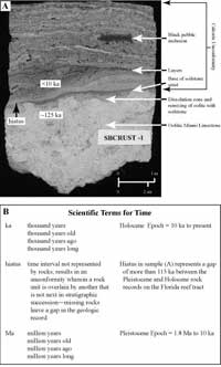
Mapping bedrock topography provides the foundational building block that shows how the shelf was flooded during the most recent rise in sea level (sea level began to rise about 15,000 years ago from a position more than 100 m lower than today) and where coral reefs of the present ecosystem would grow. By drilling cores and dating reefs in the bedrock and present ecosystems, we also learn how and when the combined accumulations built the shelf. Geophysical data collected with high-resolution seismic instruments that provide pictures of the bedrock and sediment surfaces are used to interpret bedrock topography and thickness of overlying sediments. Reef thickness is determined by core drilling. Cores are used to identify the coral species that built the reefs and determine how reefs responded to the most recent rise in sea level. These data are supplemented by radioisotope-dating techniques to derive dates or isotopic ages of corals, mangrove peat, and soilstone crusts in the cores. Mangroves grow at the shoreline in calm water. Dated mangrove peat recovered from beneath coral reefs indicates the previous existence and depth of an old shoreline, as well as time of peat formation and lack of a surf zone at the site at that time. The deepest mangrove peat found so far was recovered from ~15 m below present sea level in a core taken in the lower Florida Keys (Lidz et al., 1985). Though the amount of peat was insufficient for radioisotope dating, comparison of the depth of recovery with a local sea-level curve (Robbin, 1984) indicates that particular peat probably accumulated about 8,500 years ago. Another type of unit important for dating purposes is the 'soilstone crust' (also called calcrete; Multer and Hoffmeister, 1968; Robbin and Stipp, 1979; Fig. 7A). Such crusts accumulate as a series of wafer-thin layers through interaction of various processes (wet/dry) on limestone surfaces that are exposed to air. Dates on soilstone crusts recovered from known depths below sea level provide information on the depths and times when those sites were exposed.
Detailed digital thematic maps were constructed using a combination of techniques, including shelf-wide seismic data, high-quality aerial photomosaics of seabed features and habitats, and thin-section analyses of surface sediments. The maps are the most extensive databases in existence for a contiguous part of the Sanctuary in the vicinity and immediately west of the Florida Keys. The seismic datasets include an ~2,130-km2 area. A pie chart accompanying the habitat dataset shows that the map area includes ~3,140.5 km2. Until 2001, the size of the Sanctuary was 9,600 km2 (Causey, 2002; Fig. 6A). In July 2001, the Sanctuary was enlarged to incorporate the Tortugas Ecological Reserves (Keller et al., 2003; Fig. 6B). As of March 2005, area of the Sanctuary is now 9,844 km2. The seismic and habitat datasets encompass ~22% and 32% of the enlarged Sanctuary, respectively. Innovative cross-sectional shelf-edge models were derived using a combination of methods that address the origin, timing, and evolutionary changes in surface landforms along the reef tract over the 325,000-year period (325 ka; see Fig. 7B for scientific terms for time). The models are based on seismic-reflection contours and high-precision radiometric-age dates on corals, both correlated with globally recognized periods of high sea-level stands. |

![]() U.S. Department of the Interior |
U.S. Geological Survey
U.S. Department of the Interior |
U.S. Geological Survey
URL: [disc] /pubs/pp/2007/1751/professional-paper/mapping-reef.html
Page Contact Information: Feedback
Page Last Modified: December 01, 2016 @ 04:12 PM (JSS)