Scientific Investigations Report 2010–5245
Figures
 |
 |
 |
 |
 |
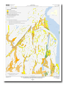
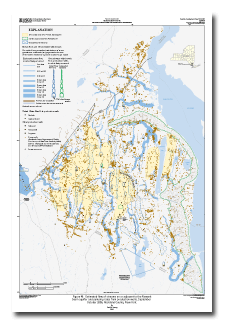
| Figure 7A. Distribution of unconsolidated glacial and alluvial deposits
in Rockland County, New York and the surrounding areas 24" X 32" PDF 2.98 MB |
Figure 7B. Thickness of glacial and alluvial deposits in Rockland County, New York and the surrounding areas 24" X 32" PDF 2.18 MB |
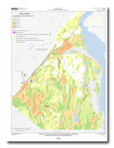
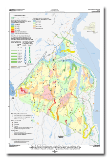
Figure 9. Distribution of (1) traprock and thermally altered host rock
and (2) bedrock-surface altitude within the Newark basin, Rockland
County, New York 24" X 36" PDF 2.45 MB |
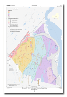
Figure 11. Newark basin aquifer zones A through D, with associated
characteristics - natural-gamma radiation and transmissivity, Rockland
County, New York 24" X 36" PDF 1.87 MB |
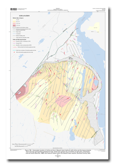
Figure 16A. Interpreted zonation of strike and dip in Newark basin bedrock with strike and dip measurements
from outcrops and borehole geophysical logs, strike from gamma-log correlation at well pairs, lineaments,
inferred faults (Ratcliffe, 1988), and traprock extent within the Newark basin aquifer, Rockland County, New York 24" X 36" PDF 2.45 MB |
 |
 |
 |
 |
 |
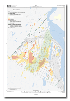
| Figure 16B. Interpreted zonation of strike and dip in Newark basin bedrock with
hydrogeologic data used in support of interpretation, Rockland County, New York 24" X 36" PDF 3.20 MB |
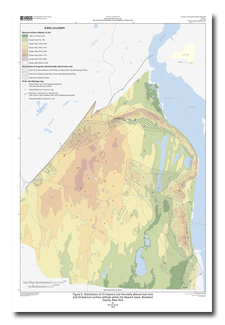
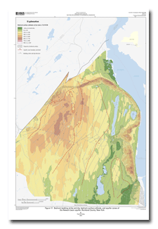
Figure 17. Bedrock bedding strike and dip, bedrock-surface altitude, and aquifer zones of
the Newark basin aquifer, Rockland County, New York 24" X 36" PDF 2.84 MB |
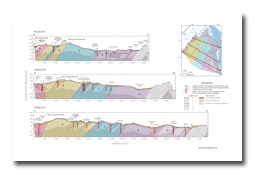
Figure 18. Diagram showing hydrogeologic sections A, B, and C, of the Newark basin aquifer, Rockland County, New York. 11" X 17" PDF 3.10 MB |
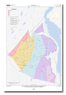
Figure 20. Well network used for groundwater-level surveys, Newark
basin aquifer, Rockland County, New York, 2005–2007 24" X 36" PDF 866 KB |
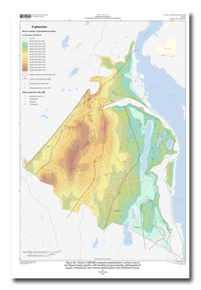
Figure 29. Historic (1920–80) composite potentiometric surface map of
the Newark basin aquifer, with locations of groundwater withdrawals for
supply, institutional, and commercial/industrial uses, Rockland County, New York 24" X 36" PDF 2.10 MB |
 |
 |
 |
 |
 |
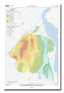
| Figure 30. Spring 2007 potentiometric-surface map with points of
groundwater withdrawal, Newark basin aquifer, Rockland County, New York 24" X 36" PDF 1.04 MB |
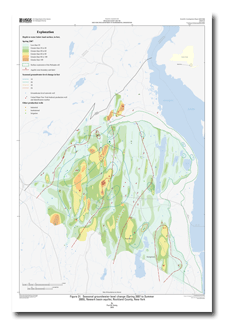
Figure 31. Seasonal groundwater-level change (Spring 2007 to Summer
2005), Newark basin aquifer, Rockland County, New York 24" X 36" PDF 1.07 MB |
Figure 32. Newark basin aquifer groundwater-flow-system map, Spring
2007, Rockland County, New York 24" X 36" PDF 993 KB |
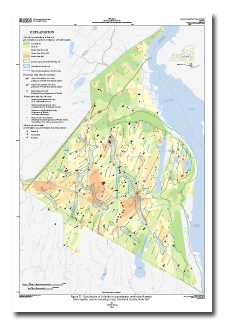
Figure 37. Distribution of chloride in groundwater within the Newark basin aquifer and surrounding areas, Rockland County, New York 24" X 36" PDF 1.75 MB |
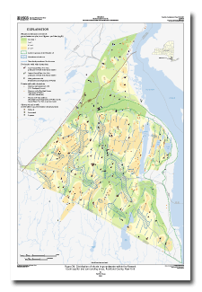
Figure 38. Distribution of nitrate in groundwater within the Newark basin aquifer and surrounding areas, Rockland County, New York 24" X 36" PDF 1.65 MB |
 |
 |
 |
 |
|
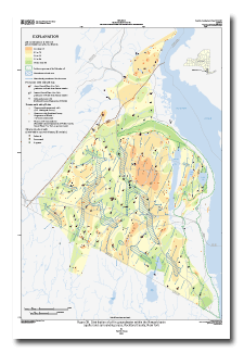
| Figure 39. Distribution of pH in groundwater within the Newark basin
aquifer and surrounding areas, Rockland County, New York 24" X 36" PDF 1.66 MB |
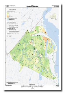
Figure 40. Distribution of sulfate in groundwater within the Newark basin aquifer and surrounding areas, Rockland County, New York 24" X 36" PDF 1.38 MB |
Figure 46. Estimated flow of streams on or adjacent to the Newark
basin aquifer and pumping rates from production wells, September-
October 2005, Rockland County, New York 24" X 36" PDF 2.84 MB |
Figure 47. Specific Conductance and estimated flow of streams on or adjacent to the
Newark basin aquifer, and pumping rates from production wells, September-October 2005,
with distribution of specific conductance in groundwater, Rockland County, New York 24" X 36" PDF 2.61 MB |

![]() U.S. Department of the Interior |
U.S. Geological Survey
U.S. Department of the Interior |
U.S. Geological Survey
URL: https://pubsdata.usgs.gov/pubs/sir/2010/5245/figures.HTML
Page Contact Information: USGS Publications Team
Page Last Modified: Tuesday, 22-Feb-2011 10:22:29 EST
