|
|
Meteorological Observations Wind speed and direction, wave height and period, air temperature, sea surface temperature, and
barometric pressure are recorded by instruments maintained in Massachusetts
Bay by the National Data Buoy Center (
NDBC-
http://www.ndbc.noaa.gov/station_page.phtml?$station=44013)
at station 44013 (figure
1). Between 1989 and 1993, the meteorological observations were made
from the Boston Approach Buoy, a 10-m Large Navigational Buoy
(LNB)
at Site A. In 1993 the Boston Approach Buoy was replaced with a
USCG Horn Buoy. The NDBC station 44013 was
moved to a location
about 7 km east of Site A (figure
1), and meteorological measurements were made from a 3-m discus buoy.
Data from these buoys at 1-hour intervals were obtained from
NDBC.
Locations of NDBC
Station 44013 |
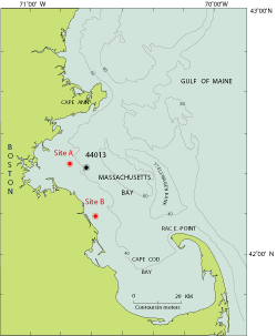
Figure 1 (PDF format) |
|
| Start |
End |
Platform |
Latitude |
Longitude |
June
1986 |
September
1990 |
10-m LNB |
42° 23.98 N |
70° 48.00 W |
October
1990 |
October
1993 |
10-m
LNB |
42° 22.80 N |
70° 46.80 W |
November
1993 |
July
1997 |
3-m Discus |
42° 21.05 N |
70° 41.48 W |
November
1997 |
Ongoing |
3-m Discus |
42° 21.23 N |
70° 41.48 W |
Streamflow Observations
Daily streamflow observations
were obtained from the U.S. Geological Survey
(
http://ma.water.usgs.gov/water_s.htm
and
http://nwis.waterdata.usgs.gov/ma/nwis/discharge).
Data from the major river that discharges through Boston Harbor into Massachusetts
Bay (the Charles, gaging station 01104500), and from the Merrimack, Parker,
and Ipswich Rivers (gaging stations 01100000 , 01101000, and 01102000,
respectively), which discharge into the western Gulf of Maine north of
Cape Ann, are included in this data report.
|
 To view files in PDF format, download free copy of Adobe Reader. To view files in PDF format, download free copy of Adobe Reader. 


|