Low-pass Filter
A low-pass filter is used to remove tidal and higher-frequency fluctuations from
the time-series data that sometimes mask smaller fluctuations in the time-series plots that are
driven by winds and the density field. The filter, called PL33 (Flagg and others 1976;
Beardsley and others, 1985),
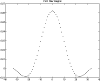
operates on hourly data values. The digital filter replaces each point with a weighted average of the
33 points on either side of the central point
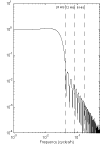
(figure 20). The filtering reduces the total
length of the time series by 66 hours (33 hours on each end). The filter transfers signals at
unreduced amplitude that have periods longer than about 50 hours
(figure 21). The half-amplitude point of
the filter is at
33 hours and the half power point is at 38 hours. The filter removes more than 99% of the amplitude at
the semidiurnal tidal periods and more than 90% of the amplitude at the diurnal tidal periods
(table).
The low-passed data are subsampled every 6 hours.

Vector-Measuring Current
Meter (VMCM)
VMCM's
record data on 1/4" cassette tapes using Sea Data recorders. After
the VMCM's were recovered, the data were read from
the cassette into a file on a personal computer, and then translated into
WHOI Carp format,
using programs Seadata and PCARPHP
(Danforth, 1990). Decoding and calibration were performed using the Buoy
Group Data Processing System. Until September 1999, data were edited,
truncated, averaged, and filtered using the Buoy System, but since then
VMCM data have been written to
NetCDF
files, and these procedures have been conducted in the
WHOI-USGS
system. Since February 2001, data were also decoded and calibrated using the
WHOI-USGS system.
SEACAT and MicroCAT
SEACAT and MicroCAT data are
stored internally. After recovery, SEASOFT programs (Sea-Bird Electronics,
Inc.) were used to read the data into a file on a personal computer, convert
to calibrated oceanographic units, calculate salinity and density, and
write the data to ASCII flat files. ASCII files were translated to Buoy
Format or NetCDF, and the data were edited, truncated,
averaged, and filtered using the Buoy System (until September 1999) or
the WHOI-
USGS system.
Acoustic Doppler Current
Profiler (ADCP)
The ADCP
observations were processed using USGS
software (available at
http://woodshole.er.usgs.gov/operations/stg/pubs/ADCPtools/)
and elements of the WHOI-
USGS Oceanographic Data Processing
system. The ADCP's were normally
configured to record
data in beam coordinates (rather than earth coordinates). Upon recovery,
the ADCP data were transferred
to a personal computer
using a
PCMCIA flash memory card. These data were converted
to NetCDF format using software available for the
ADCP
Toolbox (above). Matlab routines were used to check for data quality,
flag bad values, convert to earth coordinates using a 4-beam or 3-beam
solution, truncate the data at the beginning and end of the deployment,
and discard bins that were always beyond the water surface. Some near-surface
bins were not discarded even though the side-beam reflection at times
of low tide renders these data invalid, so near-surface
ADCP
data must be interpreted with care. On occasion, the
ADCP
skips an ensemble record because the data are poor. Data collected since
2000 have blank placeholders for the missing ensemble records. The end
result of processing is an EPIC-compatible data file.
Data Logging Current Meter (DLCM)
Tripods
When DLCM
data were recorded on Sea Data cassettes, the data were read from the
cassette into a file on a personal computer, and then translated into
WHOI Carp format,
using programs Seadata and PCARPHP
(Danforth, 1990). When DLCM
data were recorded on a
Tattletale hard disk, the Tattletale was attached to a personal computer
and the data copied into a file on the computer's hard disk, and then
translated into WHOI
Carp format using a C language program called SEADAT.
Carp format DLCM data from
both sources were processed
using a Fortran program called NEWDDISC that translates into calibrated
oceanographic units and derives current speed and direction,
PSDEV, and salinity. The WHOI
Buoy Group routine NSINP was
then used to translate the data into Buoy Group format, and the data were
edited, truncated, averaged, and filtered using the Buoy System.
MIDAS Tripods
MIDAS
data were recorded on
a Tattletale hard disk and then copied to a personal computer's hard disk
after recovery. Until February 1998, a C language program was used to
translate the data to calibrated oceanographic units, rotate the velocity
to produce east, north, and up components, and calculate pressure standard
deviation and velocity variances and covariances from the high-frequency
measurements. The result was an ASCII flat file that was translated into
the WHOI Buoy Group format
using routine NSINP, and
the data were edited, truncated, averaged, and filtered using the Buoy
System. Since February 1998, the WHOI-
USGS system has
been used to decode and calibrate the data, compute secondary variables,
and perform all further processing.
Initial processing of BASS
current meter data is based on the assumption that the speed of sound
is constant at 1500 m/s.
BASS data from 1991 to 1998 were corrected using
a time series of sound speed that was calculated from measured pressure,
temperature, and salinity using the
UNESCO algorithm (Fofonoff and Millard,
1983). In 1998, it became apparent that the sound speed corrections were
smaller than the uncertainty caused by the imprecision of the compass
and tilt sensors, so sound speed corrections were discontinued.
Transmissometer
Transmissometer data were
processed along with the other data from SEACAT and tripod systems. Beam
attenuation coefficients (units of m-1)
were computed from
the light transmission observations as -4(ln(T/100)), where T is percent
light transmission over a beam length of 0.25 m.
The beam attenuation
coefficient is linearly proportional to the concentration of suspended
material in the water if the particles are of uniform size and composition
(Moody and others, 1987). However, the size of the particles in the water
changes with time, especially during resuspension events, and thus the
beam attenuation measurements must be interpreted with care.
Wind Stress
Wind stress was calculated
from wind speed and direction using the formulas of Large and Pond (1981).
Sediment Trap Samples
After recovery of the time-series
trap, the trap bottles are cleaned and photographed. The contents are
then sieved using a 1000-micron polyethylene screen in order to remove
filamentous organic matter, such as seaweed, which would complicate the
splitting process. Samples are split on a 4-way splitter described by
Honjo (1978). The split designated for determination of mass is allowed
to settle in a refrigerator for 3-5 days, the overlying clear sea water
(and sodium azide) is measured for salinity, siphoned off, and the wet
residue is subsequently freeze dried. The mass is corrected for salt content
using the weight lost on drying and the measured salinity of the overlying
water. The grams collected per m2
per day are calculated from the measured
weight, the time of exposure under the funnel, and the cross sectional
area of the trap (0.5 m2 ).
|