 |
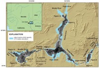
Figure 1. Location map showing the names of features referred to in the text, the bounds of the lake at full capacity, and the sidescan-sonar coverage. White boxes indicate other figure locations. Areas of low acoustic backscatter show as dark tones and areas of high acoustic backscatter show as light tones on the grayscale sidescan-sonar imagery. |
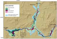 |
Figure 2. Map showing the interpreted lake-floor geology. Four units were mapped: outcrops of Tertiary and older rocks, Quaternary alluvial deposits, thick post-impoundment sediment deposits, and thin post-impoundment sediment deposits. These are represented in the map as rock, alluvial deposits, thick sediment, and thin sediment, respectively. |
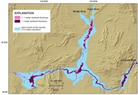 |
Figure 3. Map showing the distribution of post-impoundment sediment in Lake Mead. Areas of thin post-impoundment sediment cover (< 1 m, shown as pale purple) are mostly along the floors of the tributary valleys, while thick sediment cover (> 1 m, shown as dark purple) is mostly along the floor of the original Colorado River valley. |
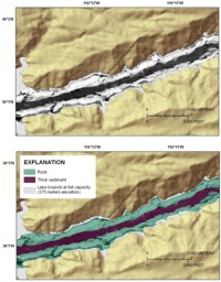 |
Figure 4. Sidescan-sonar image from Virgin Canyon showing the uniform high-backscatter signature (light tones) associated with rock outcrops. The top panel shows the sidescan-sonar image and the color-hillshade relief image of the surrounding area and indicates the steepness of the walls flanking this part of the lake. The bottom panel shows the interpretation of the sidescan-sonar image. See figure 1 for the location of this figure. |
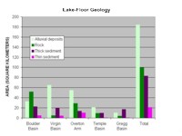 |
Figure 5. Graph showing the area (in square kilometers) covered by each of the four mapped units in each of the five mapped portions of the lake, as well as the total for the entire lake. |
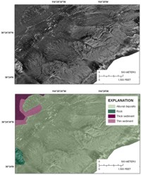 |
Figure 6. Sidescan-sonar image (top panel) and interpretation (bottom panel) showing alluvial deposits from the eastern side of Overton Arm. See figure 1 for the location of this figure. |
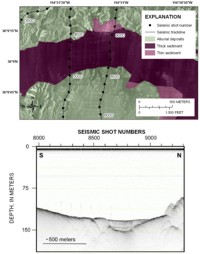 |
Figure 7. Sidescan-sonar image with interpretation (top panel) and seismic-reflection profile (bottom panel) from the western part of Virgin Basin. The sidescan image shows the low-backscatter nature of the thick post-impoundment sediment deposit in this part of the lake. The sediment is onlapping alluvial deposits. The seismic profile shows the thickness of the post-impoundment sediment. The two images are correlated by seismic shot numbers. The numbers along the top of the seismic profile are shot numbers that correspond to the dots along the seismic tracklines in the top panel. See figure 1 for the location of this figure. |
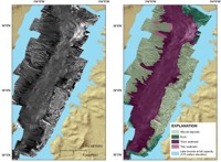 |
Figure 8. Sidescan-sonar image (left panel) and sidescan interpretation (right panel) of Gregg Basin. Alluvial deposits are exposed along both sides of the basin, and the post-impoundment sediment covering its floor shows a gradual transition from moderate backscatter (medium-gray tones) at the northern end of the basin to low backscatter (dark-gray to black tones) at the southern end of the basin. This transition appears to be due to a progressive decrease in the amount of sand in this deposit toward the south. See figure 1 for the location of this figure. |
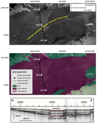 |
Figure 9. Sidescan-sonar image (top panel), interpretation (middle panel), and seismic-reflection profile (bottom panel) from Boulder Basin. The sidescan image shows the low-backscatter (dark-gray tones) nature of the post-impoundment sediment in this part of the lake. The two moderate-backscatter bands mark the edges of a low-relief channel. The seismic profile shows that this channel overlies the original Colorado River. The images are correlated by seismic shot numbers. The numbers along the top of the seismic profile are shot numbers that correspond to the dots along the seismic tracklines in the top two panels. See figure 1 for the location of this figure. |
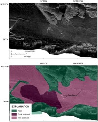 |
Figure 10. Sidescan-sonar image (top panel) and interpretation (bottom panel) showing boulders in an area of thin post-impoundment sediment cover in Las Vegas Bay. See figure 1 for the location of this figure. |
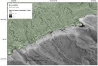 |
Figure 11. Digital orthophotograph (gray) and interpretation of the sidescan-sonar image (green) of the southern edge of Boulder Basin showing the continuation of channels from the subaerially exposed parts of the alluvial deposits with the parts that are now submerged. The preservation of the submerged parts of the channels indicates limited reworking of this part of the lake floor by waves and limited burial by post-impoundment sediment. See figure 1 for the location of this figure. The digital orthophotograph was acquired from the TerraServer Extension in ArcMap 9.2. This tool provides the ability to download imagery hosted by Microsoft's TerraServer. |
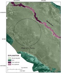 |
Figure 12. Sidescan-sonar image showing roads from the village of St. Thomas preserved on the lake floor when this survey was completed in 2001. The preservation of these features indicates little post-impoundment sediment has covered this area. Figure is located at the northern end of Overton Arm and is shown on figure 1. |
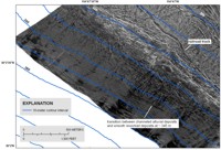 |
Figure 13. Sidescan-sonar image from the western end of Boulder Basin showing the transition between alluvial deposits in the upper right part of the image and smooth reworked deposits in the lower left. The reworked deposits are alluvial deposits that presumably were reworked and smoothed by seasonal changes in lake level during the first half of the history of the lake. See figure 1 for the location of this figure. |
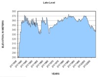 |
Figure 14. Monthly lake-level elevations between February 1935, when the lake started filling, and May 2009 (U.S. Bureau of Reclamation, 2009). The major drop in lake level in the mid-1950s was due to a drought, and the second major drop in the mid-1960s coincides with the filling of Lake Powell. Note that seasonal variations in lake level prior to filling Lake Powell are 10-15 m, while they are much less since then. |