|
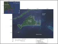
The 2011 OASIS experiment was conducted on the New England inner shelf at a depth of about 12.5 meters (m), approximately 2 kilometers (km) south of Martha's Vineyard, Massachusetts (fig. 1). This is the location of the 12-m node (described below) of the MVCO, the site of two previous OASIS experiments in 2005 and 2007, and the ONR mine burial experiment in 2002. Tidal range at MVCO is about 2 m, tidal currents are predominantly east-west alongshore, and swell waves propagate mostly northward toward the shore. The bottom is characterized by sorted bedforms (also called rippled scour depressions) that are about 40 to 200 m wide and extend from depths of 4 to 18 m (Goff and others, 2005; Denny and others, 2009; Sherwood, 2011). These features are broad ribbons of fine sand with small ripples alternating with regions of coarse sand with larger ripples.
The 12-m node is located in the middle of a fine patch, with mostly fine, well-sorted sand and less than 5 percent silt plus clay (median grain diameter 2.5-2.6 phi, standard deviation 0.78-1.1 phi). Patchy deposits of fine sediment were sometimes found near the 12-m node; in one of the two grab samples taken on the recovery cruise on October 23, 2011, the top 2 to 3 centimeters (cm) included soft, unconsolidated mud (more than 58 percent silt and clay) on top of cleaner, fine sand. Diver observations and sonar data from previous surveys indicated that the small-scale bottom topography included small anorbital ripples (with a height of about 0.008 m and wavelength of about 0.10 m). These ripples were superimposed on larger scale (wavelength of about 2 m) undulatory bedforms. In some multibeam surveys it appeared that the fine sand was eroded to provide windows into underlying coarser sand, particularly near features that created local scour (for example, the underwater node housing, mine-like objects deployed during the Mine Burial Experiments, and probably tripods; Traykovski and others, 2007).
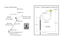
The 12-m node was an underwater structure that provided subsea connections for Internet and power, and the site for long-term acoustic doppler profiler measurements. The connection was housed in a 2-m-tall structure accessible by divers. A post ( fig. 4A, strain pipe) was jetted into the seafloor a few meters south of the underwater housing; this was used to provide strain relief for temporary cables running from instruments (including the specially modified tripod with a moving arm deployed for this survey) to the underwater housing. In addition, two taut ground lines ran about 14 m from this post to two helical mooring anchors, one nearly due north of the node and one southwest of the node. The moorings attached to these anchors had taut subsurface floats tethered about 5 to 6 m above the bottom by elastic rodes. Above these floats, surface floats were attached to a slack line approximately 17 m long (fig 4B). Our tripod (USGS mooring 910) was deployed 3 to 5 m southwest (260 degrees (°) from magnetic north) of the southern anchor, beyond the watch circle of the subsurface floats but within the watch circle of the surface float. The moving arm pointed toward the southeast (143° from true north ±5°). After deployment, our cables led directly from the northern foot of our tripod to the strain-relief pipe, where excess cable was coiled, and from there to the underwater connector. A monopod with an Aquadopp profiler (USGS mooring 911) was deployed about 3 to 5 m southeast of our tripod.
|