FISC - St. Petersburg
|
Summary
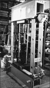
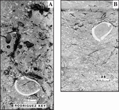
Limestone Compaction: Carbonate buildups have long been a focus of intense geologic study but initially for reasons other than the ecosystem decline and environmental concerns that are paramount today. Geologists originally studied modern reefs mainly as an aid to understanding the distribution and life requirements of ancient reefs. An underlying reason is that many ancient reefs are significant hydrocarbon (oil and gas) reservoirs. Various types of reefs, including those made of coral, have existed for hundreds of millions of years, and the majority lies buried in the subsurface. Globally, ancient subsurface coral reefs and other types of organic-carbonate buildups that have undergone sufficient overburden (burial) and thermal maturation (pressure) through time (tens of millions of years) have become reservoirs of the hydrocarbons we use today. Most hydrocarbons are trapped in porous and permeable limestone that has a three-dimensional structure and that escaped complete marine and later groundwater or freshwater cementation. Structural hydrocarbon traps include impermeable overlying strata, buried salt domes, and fault blocks, to name a few. Oil and gas have long been pumped from such structures along a 1,000-mile trend of Cretaceous reefs (~144 to 66 Ma, Fig. 7B) along the Gulf of Mexico coast. This trend includes the producing Sunniland Field (Fig. 116) as well as 13 other producing wells in Florida. Thus, early incentives to study modern reefs, along with the few ancient reefs exposed by mountain-building processes and erosion, were driven mainly by economic concerns. Of particular interest was the question of how the high porosity (up to 50% of any living coral reef is void space) can be preserved after burial. USGS studies of modern coral reefs using seismic instruments and portable underwater coring devices were initially aimed at unveiling the factors that control reef distribution, thickness, and porosity. Porosity was also examined in laboratory experiments. Hydraulic presses were used to squeeze or compact lime muds from Biscayne Bay and skeletal coral sands from Rodriguez Key to simulate burial and determine the amount of porosity that might survive and become a reservoir for fluid (Figs. 137, 138A, 138B; Shinn et al., 1977b, 1978; Chanda, 1978; Shinn and Robbin, 1983). The compaction studies were also aimed at discovering clues derived from the internal structure of modern muds and reefs to recognize how changes in sediments and fossils occur over time.
The compaction studies replicated sedimentary features commonly found in ancient fine-grained limestone. Included (Fig. 138) were (a) flattened burrow fillings; (b) mashed or obliterated fecal pellets; (c) obliterated small voids and identifiable sea grasses; (d) reorientation of fossils toward the horizontal; (e) minor breakage of fossils; and (f) creation of wispy organic layers that often drape over fossils or other less compactable inclusions. Shinn and Robbin (1983) showed that lime sediments with marine pore waters can readily compress to at least half their depositional thickness and approximately half their original porosities under as little as 100 m (328 ft) of simulated overburden (burial). Significant compaction resulted from pressures simulating less than 305 m (1,000 ft) of burial. Minor chemical compaction (pressure dissolution, evidenced by thin sections showing quartz grains piercing mollusc shells without causing fractures) was observed in cores compacted at room temperature to a simulated overburden of 4,136 m (13,568 ft) for as little as 4 days. Given geologic time, significant chemical compaction probably occurs at depths much shallower than 4,100 m. |

![]() U.S. Department of the Interior |
U.S. Geological Survey
U.S. Department of the Interior |
U.S. Geological Survey
URL: [disc] /pubs/pp/2007/1751/professional-paper/summary/modern-reefs.html
Page Contact Information: Feedback
Page Last Modified: December 01, 2016 @ 04:12 PM (JSS)