|
 |
 |
Primary Products - Overview Maps & Evolution Overview:
|
|
|
|
|
|
|
|
|
|
|
|
|
|
|
|
|
|
|
|
 |
|
|
|
|
|
|
|
|
|
|
|
|
|
|
|
Summary
Ancient Reefs: To complement USGS studies of modern reefs in the Florida Keys, Bermuda (Shinn, 1971), Belize, Central America (Shinn et al., 1982), the Bahamas (Halley et al., 1983), Enewetak Atoll, Pacific Ocean (Shinn et al., 1986), and elsewhere, the well-traveled USGS underwater core drill (Fig. 139A, 139B) was used to examine ancient outcropping bioherms or organic reefs in the Sacramento Mountains of New Mexico. Two of the best-studied reefs, known to geologists as Scorpion and Muleshoe Mounds, are found in the mountain range east of Tularosa and Alamogordo (Fig. 140A, 140B). Both are popular stops on geologic field trips to study carbonate formations of the southwestern U.S. Both were core drilled in 1981 to study reef distribution, bioherm construction, sedimentation, cementation, and compaction history (Shinn et al., 1983).
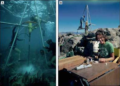
Figure 139. Hydraulic core drill being used to core (A) a coral reef at Grecian Rocks in the upper Florida Keys and (B) (after adaptation for use on land), an uplifted and exposed algal reef at Scorpion Mound in the Sacramento Mountains outside Tularosa, New Mexico. Scorpion core segments were examined microscopically on site. Horizontal bar attached to drill is a stabilizer, enabling the drill to turn the drill string. [larger version] |
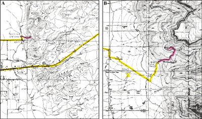
Figure 140. Topographic maps show approximate elevations above present sea level in areas of (A) Scorpion Mound and (B) Muleshoe Mound. Colors indicate routes traveled by car (yellow) and on foot (pink). The hike to Scorpion was ~0.5 km and the climb up ~84 m (1/3 mi and up 275 ft, the difference between the map-contour elevation at closest parking area and elevation at top of the mound). The hike to Muleshoe was ~1.6 km and the climb ~258 m (1 mi and up 846 ft). The crest of Muleshoe is about 100 m (328 ft) high. [larger version] |
The cores yielded valuable information difficult or otherwise impossible to obtain by conventional outcrop examination and peripheral sampling with a rock hammer. Scorpion Mound, of Permian age (~250 Ma, Fig. 7B), is a buildup of phylloid (leaf-shaped) algae (Fig. 141A, 141B, 141C). A 16.5-m core through the center of the mound (Shinn et al., 1983; Figs. 141D, 142A, 142B, 142C, 142D) revealed a 15-m-high reef that had been growing on a sandstone topographic high thought to be an ancient tidal-channel levee. The outcrop wall showed a 30-cm-thick sandstone layer underneath the reef, but the core through the mound proved the layer was more than 1 m thick (Fig. 143A). The observation that the reef was initiated on a topographic high could not have been determined from outcrop examination alone.
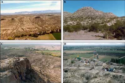
Figure 141. Photos show (A) aerial view of line of algal reefs in the Sacramento Mountains at Tularosa, New Mexico. Scorpion Mound is the largest outcrop at center right in this view. Note staging area and USGS van and trailer (circled). (B) View of Scorpion Mound from parking area. Note driller on way up path at right. (C) Driller (circled) stands on drill site. Ledge to right of driller was used for microscope table and other gear (Fig. 139B). (D) On site, drilling Scorpion Mound overlooking Tularosa to the southwest. Note green water barrels at left, core barrels in center, and gasoline-powered generator (downwind to dampen noise) in left foreground. Water in barrels was used to lubricate the drill string. [larger version] |
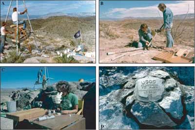
Figure 142. (A) Drilling Scorpion Mound while looking east. Note cement bag on top of drill string under seated driller, both for added weight. (B) Extruding limestone core from a core barrel. (C) Examining core segments under the microscope. (D) Upon completion, the drill hole was plugged with rags and cement and marked with country (native) rock. TD = total depth. [larger version] |
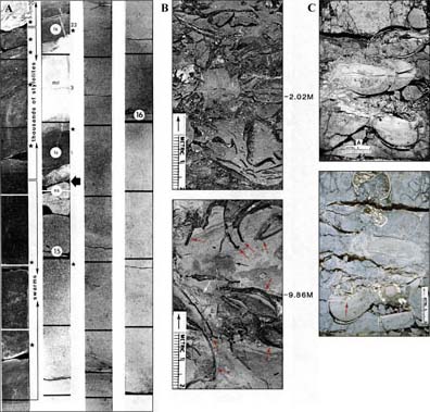
Figure 143. (A) Bottom 2.4 m (7.9 ft) of Scorpion Mound core (from Shinn et al., 1983). Horizontal black bands mark 10-cm (4-in.) intervals. Stars indicate areas that were thin sectioned. Stylolites are irregular interlocking contact surfaces that fit together, usually occurring in homogenous carbonate rocks. The seam is characterized by a concentration of insoluble constituents of the rock. Stylolites are formed by chemical alteration under pressure accompanied by dissolution (Dunnington, 1954). Swarms = >40 stylolites per 10-cm section. ls = limestone. dol = dolomite. ss= sandstone. Bold arrow marks top of underlying massive sandstone, which extends to 16.5 m (54.1 ft) depth (bottom of core). Total thickness of sandstone is not known. (B) Enlarged sections of Scorpion core (from Shinn et al., 1983). Top section shows internal sediment around phylloid algae (envision a bowl of potato chips infiltrated with sand). Note stromatolite in center of lower section (black arrow), stylolite (white arrow), and phylloid algae (red arrows). (C) Sawed, plastic-impregnated sections of experimental core of Portland cement and chicken eggshells that simulate phylloid algae in lime mud (from Shinn et al., 1983). Compare with features visible in Scorpion Mound limestone (B). Note laminated geopetal filling (internal structure that indicates original relation of top to bottom at time of formation; red arrow) associated with fractured eggshells. Also note broken lumps of Portland cement outside eggshell to right of arrow and lack of fracturing typical of lime mud. The lumps simulate collapse breccia in limestone (see, for example, Fig. 83A, 83B). The Scorpion Mound core contained numerous areas of collapse breccia. Large voids in (C) are artifacts of shrinkage during sample preparation. [larger version] |
Interpretation of the sandstone structure at the base of the core also might not have been possible without a previous study of modern reefs in Belize. Choi and Ginsburg (1982) demonstrated that an underlying Pleistocene fluvial system, formed when sea level was lower, controlled the distribution of both Pleistocene and modern coral reefs on the Belize platform. When the sea flooded the fluvial plain of the Belizean shelf, reefs initially began growth on cemented riverbanks, especially the higher levees that are found at outer bends or meanders of a river.
Another discovery made possible by the Scorpion Mound core was that partial early marine cementation and internal sedimentation had occurred before burial and compaction, and that later precipitation of calcite from groundwaters obliterated the porosity that had survived the initial stages of burial compaction (Shinn et al., 1983; Fig. 143B). This interpretation would not have been possible without the experimental compaction studies and comparison with cores from modern reefs. Experimental studies using chicken eggshells to simulate phylloid algae produced structures almost identical to those in Scorpion Mound (Shinn et al., 1983; Fig. 143B, 143C). Again, knowledge gained from field and laboratory studies of modern reefs and compaction processes provides information for interpreting the distribution of and porosity in buried ancient reefs.
Muleshoe Mound, of Mississippian age (~350 Ma, Fig 7B; Fig. 144A, 144B, 144C, 144D, 144E, 144F), is very different in composition from the "algal" mounds at Tularosa. It is roughly 100 m high and had been called a "mud" mound by earlier workers on the basis of outcrop samples. Our 21-m-long core taken at the apex of the mound provided 100% recovery (Fig. 145A, 145B, 145C, 145D, 145E, 145F). The polished core shows that the mound consists almost entirely of marine cement (limestone precipitate) that grew upward from the sea floor as mounded magnesium-calcite crystals (Shinn et al., 1983). In effect, the mound is a large accumulation of precipitated limestone that encased delicate lacy crinoids and bryozoans that were growing on the surface of the mound as precipitation occurred. This reef never contained porosity even when it was accreting. Today, the only porous sediments are the crinoid and bryozoan sands at the outer edges of the mound. Apparently, as the organisms on top of the mound died, their fragments were swept off and accumulated as flanking beds (Shinn et al., 1983; Fig. 144B). As a target for water or oil exploration, similar reefs buried in the area would likely not be producers. The sediments that flank them might have retained porosity, but they would have to occur beneath impermeable layers to harbor hydrocarbons.
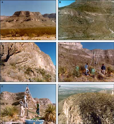
Figure 144. Aerial photos show (A) setting of Muleshoe Mound (M in center) in the Sacramento Mountains southeast of Albuquerque, New Mexico, (B) flanking beds in gorge on south side of mound in front of linear rock exposure, and (C) westward-facing mound escarpment. Escarpment is slightly more than 100 m (328 ft) high. Note drillers at base (circled). (D) Drill site on crest of Muleshoe. Food was wrapped in a plastic bag and hoisted to the top of the 4-m-tall (13-ft) tripod at the end of the day to protect against wildlife marauders. (E) Drill rig and drillers atop Muleshoe with “kiddie pool” mud pit in foreground. The Gobbler Formation in background is of Pennsylvanian age (~300 Ma; Fig. 7B). (F) Aerial view of Muleshoe and drill site (tripod circled). [larger version] |
Without studies of modern processes in growing reefs and an understanding of how and why modern reefs such as those in the Florida Keys are located where they are, the nature and timing of porosity obliteration in the ancient Scorpion and Muleshoe Mound reefs might never have been recognized. As in cored underwater corals that will eventually overgrow the plugged core holes, the core holes in both New Mexico reefs were plugged, in those cases to prevent harm to wildlife (Fig. 142D, 145F).
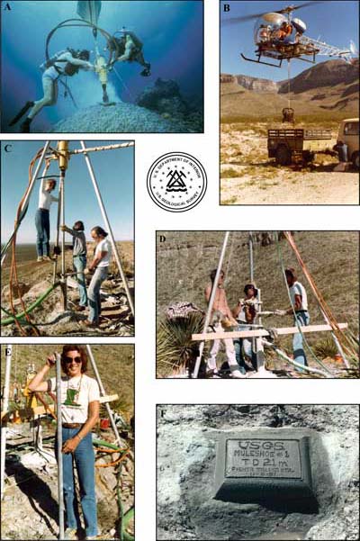
Figure 145. An airbag (A) is used to lift drilling equipment up from the sea floor, and a chartered helicopter (B) was required to airlift gear up mountains. Supplies included the gasoline generator (shown) and two 55-gallon drums of water for use as hydraulic fluid. Except for days when setup and breakdown of equipment took place, drillers climbed up to and down from the drill sites each day. (C) Drillers attach 1.5-m (5-ft) segment of core barrel to the drill and drill string in the ground. (D) Drillers use large wrenches to secure drill string and raise and remove core barrels containing limestone core. (E) Recovery of 21 m (68.9 ft) of core in 1.5-m (5-ft) sections was 100% at Muleshoe. (F) Completed drill site. TD = total depth. [larger version] |
Muleshoe Mound is ~350 Ma. Scorpion Mound is ~250 Ma. The hydrocarbon-producing Cretaceous Gulf Coast trend is between 144 and 66 Ma. Coral reefs of the Florida Keys are comparatively young, ranging in age from <236 ka to ~2 ka (Table 4, Table 5). Over tens of millions of years and under the right conditions of burial, pressure, porosity, permeability, and confinement by impermeable strata or structural traps, the Florida reefs could one day become hydrocarbon reservoirs (Fig. 146).

Figure 146. Enhanced Thematic Mapper Plus image, acquired in May 2000 from the Landsat 7 satellite, shows the four geographic components of the South Florida Ecosystem: the Everglades (south part), Florida Bay, the Florida Keys, and the reef tract. Protected mangroves fringe virtually every visible shoreline. The upper and middle Florida Keys are an emergent 125-ka coral reef. The lower Keys are emergent fossil ooid tidal bars of the same age. Seaward of the keys lie habitats of the inner shelf, the bedrock depression beneath Hawk Channel, sands and Holocene reefs on the shallow outer shelf, and 30-m-high 80-ka fossil reefs at the shelf edge. The Gulf of Mexico is at left, Straits of Florida at right. [larger version] |
continue to: Fate of the Present Coral Reef Ecosystem
|


