|
 |
 |
Primary Products - Overview Maps & Evolution Overview:
|
|
|
|
|
|
|
|
|
|
|
|
|
|
|
|
|
|
|
|
 |
|
|
|
|
|
|
|
|
|
|
|
|
|
|
|
Tile 1
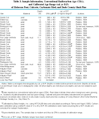
Table 3. Ages of radiometrically dated non-coral Holocene materials from the Florida reef tract (footnotes modified from Lidz, 2004). Site locations shown on Summary Illustration index map. Authors cited listed in References. [larger version] |
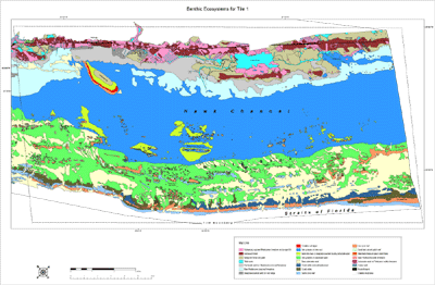
Rodriguez Key: Rodriguez Key is a nearshore mangrove island surrounded by a shallow mud bank (Fig. 22B). The island began to develop a few thousand years ago when poor water circulation in very shallow depths allowed mud to collect in a concave indentation within bedrock. Mud continued to accumulate with rising sea level, forming a mud bank that supported mangroves. The seaward edge of the bank evolved into a branching-coral and coralline-algae zone (Turmel and Swanson, 1976) that protects the muddy surface and mangroves of the island from incoming waves. Species of the red alga Goniolithon are so dense they have produced a distinct habitat (see Benthic Ecosystems for Tile 1). Exposed to air during spring low tides, the coralline-algae habitat excludes most corals, but branching corals, generally species of Porites, rim its deeper seaward side. Turmel and Swanson (1976) obtained a conventional radiocarbon (14C) age on mangrove peat recovered from ~4.3 m below sea level in a core at Rodriguez Key. Calibrated to correlate with ages obtained using high-precision age-dating methods on material older than about 30 ka, the oldest peat age ranged from 6,530 to 6,180 cal. yr B.P. (calibrated years before present) (Table 3). The mud bank is slightly older than about 6,530 cal. yr B.P.
continue to: Sinkhole
|