|
 |
 |
Primary Products - Overview Maps & Evolution Overview:
|
|
|
|
|
|
|
|
|
|
|
|
|
|
|
|
|
|
|
|
 |
|
|
|
|
|
|
|
|
|
|
|
|
|
|
|
Tile 4
Topographic Features in Bedrock: The seismic reflection marking the Pleistocene surface is readily visible everywhere along the south Florida shelf (e.g., Lidz et al., 1997b). Bedrock topography is well established (e.g., Enos, 1977; Lidz et al., 2003). Overall depth below sea level is generally shallow (<12 m ), and the shelf slopes seaward with a very low gradient (e.g., Perkins, 1977). Large geomorphic features (the Florida Keys, the bedrock depression beneath Hawk Channel, and outer-shelf coral reefs) parallel the curve of the shelf edge.
Seismic profiles in the Tile 4 sector contain good examples of subsurface geologic features that characterize much of the shelf bedrock. A profile just seaward of Crawl Key (Figs. 68B, 69) shows that the Pleistocene surface near the island chain, though under water, is generally bare of sediment. Sediment cover begins where bedrock gradient dips to form the northwest edge of the depression beneath Hawk Channel. The sediment/rock contact is clearly evident in seismic sections, and sediments line the bedrock channel-wide (Fig. 70). General rock depth in this area of Hawk Channel is ~11 m
below sea level.
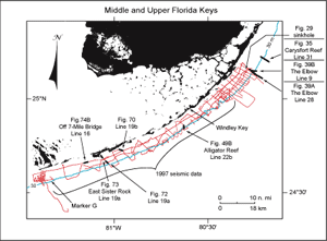 Figure 69. Index map shows USGS seismic tracklines (red) in upper and middle Florida Keys and those portions of profile data selected (bold black) from the Tile 1, 2, and 4 sectors for illustration with their figure numbers (modified from Lidz et al., 2003). Note that profiles illustrated in Tiles 2 (Fig. 49B) and 4 (Figs. 70, 72, 73, 74B) were acquired in 1997 and constitute part of the 'new' high-resolution seismic data used to develop the updated Bedrock Surface and Sediment Thickness maps. Shelf-margin contour (blue) is in meters. [larger version] Figure 69. Index map shows USGS seismic tracklines (red) in upper and middle Florida Keys and those portions of profile data selected (bold black) from the Tile 1, 2, and 4 sectors for illustration with their figure numbers (modified from Lidz et al., 2003). Note that profiles illustrated in Tiles 2 (Fig. 49B) and 4 (Figs. 70, 72, 73, 74B) were acquired in 1997 and constitute part of the 'new' high-resolution seismic data used to develop the updated Bedrock Surface and Sediment Thickness maps. Shelf-margin contour (blue) is in meters. [larger version] |
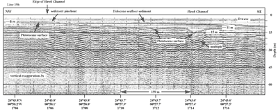
Figure 70. Bedrock depression (at right) southwest of Toms Harbor and Duck Key Channels (middle Keys, Fig. 68B) may represent extensions of one of those channels (from Lidz et al., 2003). Note sediment pinchout (at left) against smooth bare rock surface under Hawk Channel. D wave = direct arrival (not a geologic feature). 'Multiples' are an artifact common in seismic-reflection data. These reflections replicate those of existing, overlying, geologic surfaces and should not be regarded as representing any subsurface stratigraphic horizon. Latitude and longitude in degrees and decimal minutes based on GPS coordinates. Hours (military time) below coordinates serve as navigational correlation points along seismic line. [larger version] |
The Crawl Key profile also reveals what looks like a narrow V-shaped "hole" ~15 m deep within the Hawk Channel depression. The hole could represent a linear ditch, a circular karst depression, the edge of a ditch or circular depression, or many other types of topography. In other words, geometric patterns of topographic surfaces as seen on the seismic record may be true (real) or apparent (distorted). The patterns depend on orientation (perpendicular vs. diagonal) and location (center vs. edge) of the trackline relative to the feature and on whether the trackline remains straight. A good example of how geometric patterns change with a change in trackline-to-feature orientation is evident in sediment accumulations west of the Marquesas Keys in the Gulf of Mexico (Fig. 71). A similar V-shaped depression is visible in a deeper, more central part of the Hawk Channel low just east of East Washerwoman Shoal (Figs. 69, 72). Whether the two depressed areas within the main channel bedrock low are related or connected is not known.
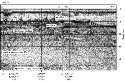
Figure 71. Profile of sand waves on channel bottom west of Halfmoon Shoal in the Gulf of Mexico (Fig. 6C) shows examples of true and apparent geometric patterns (from Shinn et al., 1990). From left to right, the N-S portion of the seismic line crossed perpendicular to 5-m-high sand waves and shows their true images. The vessel then made a course change (c/c) to NE-SW and crossed tangential to the end of the sand-wave field. Note how the image of the last sand wave has become broad and flat, giving an apparent image of an elongated smoothed section of sand. 'Multiples' are an artifact common in seismic-reflection data. These reflections replicate those of existing, overlying, geologic surfaces and should not be regarded as representing any subsurface stratigraphic horizon. Latitude and longitude below vertical time lines on profile in degrees and decimal minutes based on Loran C TDs (Time Differences). Hours (military time) below coordinates serve as navigational correlation points along seismic line. [larger version] |
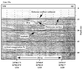
Figure 72. V-shaped depression in seismic profile from just east of East Washerwoman Shoal (middle Keys, Fig. 68B) may be the true image of a geologic feature with a southeastward trend (from Lidz et al., 2003). 'Multiples' are an artifact common in seismic-reflection data. These reflections replicate those of existing, overlying, geologic surfaces and should not be regarded as representing any subsurface stratigraphic horizon. The multiple indicated in this profile mimics the reflection of the Pleistocene bedrock surface. Latitude and longitude in degrees and decimal minutes based on GPS coordinates. Hours (military time) below coordinates serve as navigational correlation points along seismic line. [larger version] |
continue to: Geologic Highlights
|


