USGS - science for a changing world

FISC - St. Petersburg

Coastal & Marine Geology Program > Center for Coastal & Watershed Studies > Professional Paper 1751

Systematic Mapping of Bedrock and Habitats along the Florida Reef Tract—Central Key Largo to Halfmoon Shoal (Gulf of Mexico)

USGS Professional Paper 1751

by Barbara H. Lidz, Christopher D. Reich, and Eugene A. Shinn

Introduction:
Table of Contents
Project Overview
Project Objective
Geologic Setting
Primary Datasets
Primary Products - Overview Maps & Evolution Overview:
Bedrock Surface map.
Introduction
Depth to Pleistocene Bedrock Surface
Reef & Sediment Thickness
Benthic Ecosystems & Environments
Sedimentary Grains in 1989
Summary Illustration Index Map
Evolution Overview
Tile-by-Tile Analysis
Satellite image of the Florida Keys showing location of tiles.
Organization of Report
Tiles: 1, 2, 3, 4,
5, 6, 7/8, 9/10,
11
Summary
Acknowledg-
ments
References
Disclaimer
Related
Publications

Tile 4

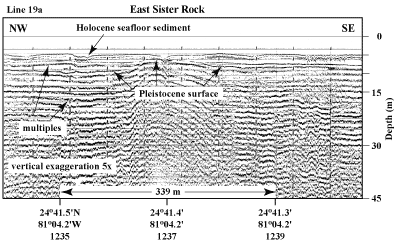
East Sister Rock: Coring has shown that, except for coral spurs (e.g., Shinn, 1963, 1980a; Lidz et al., 1985), modern reefs of the Florida Keys developed on sediment-free bedrock highs (e.g., Shinn et al., 1977a, 1989a). It has long been known from field observations, however, that Holocene corals did not colonize all bedrock highs. No one knows why.

One such uncolonized area has been documented seismically (Lidz et al., 2003). East Sister Rock lies just off the east-southeast corner of Vaca Key (Figs. 68B, 69) in ~5 m of water. The surface of East Sister Rock is about 6 m below sea level and is covered by thin Holocene sediments (Fig. 73). Surrounding bedrock is slightly deeper (~7 to 8 m below sea level).

Seismic profile northeast of East Sister Rock
Figure 73. Seismic profile northeast of East Sister Rock (south of Vaca Key in the middle Keys, Fig. 68B) shows bedrock high not colonized by Holocene reefs but surrounded and covered by Holocene sediment (from Lidz et al., 2003). 'Multiples' are an artifact common in seismic-reflection data. These reflections replicate those of existing, overlying, geologic surfaces and should not be regarded as representing any subsurface stratigraphic horizon. Latitude and longitude in degrees and decimal minutes based on GPS coordinates. Hours (military time) below coordinates serve as navigational correlation points along seismic line. [larger version]

Coastal & Marine Geology Program > Center for Coastal & Watershed Studies > Professional Paper 1751

Accessibility FOIA Privacy Policies and Notices

Take Pride in America logo USA.gov logo U.S. Department of the Interior | U.S. Geological Survey
URL: [disc] /pubs/pp/2007/1751/professional-paper/tile4/east-sister-rock.html
Page Contact Information: Feedback
Page Last Modified: December 01, 2016 @ 04:14 PM (JSS)