FISC - St. Petersburg
|
Tile 5
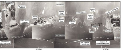
Bahia Honda Channel: With one exception (in Bahia Honda Channel), water depth to bedrock within tidal passes between the keys is inferred. In general, the passes are too shallow to accommodate the larger research vessels required to navigate rough seas on the outer shelf and shelf margin. The widest passes are in the middle Keys, but the widest pass is not the deepest. Field observations and navigational charts indicate that bedrock in most channels is about 4.5 m deep at most, including in Moser Channel. The deepest pass (i.e., depth to bedrock) anywhere in the keys may be the depression under Bahia Honda Channel, located south of the eastern lower Keys (Figs. 77C, 81). Records maintained by Overseas Railway engineers in the early 1900s noted that bedrock encountered during bridge construction in the lower Keys was deepest in Bahia Honda Channel (Spanish for "Deep Bay;" Parks, 1968). Railway workers recorded maximum depth at 10.7 m below sea level but they "hit a spot that was not only deep but seemed bottomless. It took a shipload of sand, gravel, and cement to fill" (Parks, 1968, p. 23). Neither USGS seismic data (Lidz et al., 2003) nor those of Enos (1977, his fig. 39F) provide adequate coverage to confirm the 10.7-m depth or to connect this channel to the shelf margin. Aerial photographs also provide no evidence of a connection. However, both seismic datasets indicate a deep area (>13 m below sea level) just south of the channel, and Bahia Honda Channel may be the southern extension of Big Spanish Channel (Figs. 77C, 81). Navigation charts indicate seafloor depths within Big Spanish Channel are ~2 to 4 m (NOAA, 1993). The combined channels connect the Gulf of Mexico with Hawk Channel today (Smith, 1994).
|

![]() U.S. Department of the Interior |
U.S. Geological Survey
U.S. Department of the Interior |
U.S. Geological Survey
URL: [disc] /pubs/pp/2007/1751/professional-paper/tile5/bahia-honda.html
Page Contact Information: Feedback
Page Last Modified: December 01, 2016 @ 04:14 PM (JSS)