|
 |
 |
Primary Products - Overview Maps & Evolution Overview:
|
|
|
|
|
|
|
|
|
|
|
|
|
|
|
|
|
|
|
|
 |
|
|
|
|
|
|
|
|
|
|
|
|
|
|
|
Tile 9/10
Impact of Exploratory Oil Wells on Benthic Habitats off Florida: Within a 43-year period after the 1943 discovery of oil at the Sunniland Field in southwest Florida, 14 exploratory wells were drilled in shallow water in the vicinity of the Florida Keys (Fig. 116). Five of those sites were located near the Marquesas Keys in the Gulf of Mexico (Fig. 117). Approximately 30 wells were drilled in deep water off the Gulf Coast of Florida. Two were off Ft. Myers on the west-central Florida coast (Fig. 118). Drilling of the five sites near the Marquesas Keys was conducted using now-outdated technology and prior to current Minerals Management Service (MMS) and Outer Continental Shelf (OCS) drilling restrictions and regulations. Drilling of the sites off Ft. Myers was conducted using updated technology and followed strict MMS/OCS regulations.
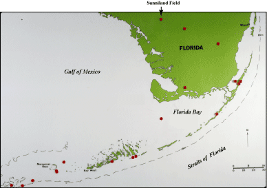
Figure 116. Index map shows sites of exploratory oil wells drilled in south Florida. The Sunniland Field was discovered in 1943 and is a producing well. [larger version] |
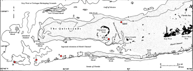
Figure 117. Generalized bathymetric map of Marquesas Keys and reef tract area west of Key West, Florida, shows locations of shallow (water depth 5-23 m) wells drilled between 1959 and 1962 (Table 9, after Dustan et al., 1991). Site D/E-1 represents two adjacent wells on a seagrass/gorgonian hardbottom 2 km southeast of the Marquesas (Table 10, after Dustan et al., 1991). Well 826Y was drilled on limestone bedrock 7 km northeast of the Marquesas. Well A was drilled from a jackup rig on coral bottom. Well C was drilled on sandy bottom, and well B, a few kilometers west of C, was drilled on a coral knoll. Well symbols are standard industry symbols for dry wells but are colored red for easy detection in this figure. Stippled pattern represents shallow submerged shelf. [larger version] |
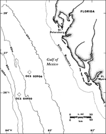 | Figure 118. Bathymetric map off west-central Florida shows locations of deep (water depth 53-70 m) wells drilled in 1981 and 1986 (from Dustan et al., 1991; Table 9). Well symbols are standard industry symbols for dry wells. Both wells were drilled into limestone bedrock that was covered with a veneer of sand (Table 10). [larger version] |
The offshore Marquesas Keys and Ft. Myers well sites were examined in 1988 to determine the ecological impact of drilling on the benthic communities (Shinn et al., 1989a; Dustan et al., 1991). The wells were drilled between 1959 and 1986 (Table 9), so the time between drilling and the 1988 study ranged from 2 to 29 years. Water depths ranged from 5 to 70 m. Well depths ranged from 1,429 to 4,662 m (4,689 to 15,296 ft). Bottom habitats included sand, bedrock, gorgonian hardgrounds, seagrass beds, and coral reefs (Table 10).
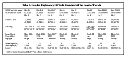 |
Table 9. Locations and descriptive data for eight shallow- and deep-water exploratory oil wells drilled off the southeast and west coasts of Florida. Wells D and E-1 are adjacent to each other and are considered a single study site (from Dustan et al., 1991). [larger version] |
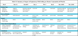 |
Table 10. Summary: impacts of drilling exploratory oil wells on marine communities off Florida. Wells D and E-1 are considered a single site (from Dustan et al., 1991). [larger version] |
Unlike production wells that remain in place for tens of years, exploratory drilling is a one-time perturbation to the habitat. Despite the well depths of several thousand meters, the study found no significant accumulations of drill muds or rock cuttings at any of the sites and no measurable ecological damage from muds or cuttings. Long-term disturbances were due to physical habitat destruction and presence of discarded drilling debris. The debris had provided substratum that created an artificial-reef effect for fish, lobsters, and encrusting organisms.
The latitude and longitude of the well sites were known from drilling records. The exact locations of the shallow well bores were located in those areas by conducting a magnetometer search from a research vessel. Several thousand feet of iron casing left in the boreholes produced strong magnetic anomalies (Fig. 119). A variety of techniques was used to assess biological and ecological impacts. At the shallow sites, snorkelers and scuba divers collected sediments, conducted point counts of organisms along chain transects and in quadrats, and probed with a rod to determine gravel and sediment thicknesses. Sediments were later analyzed for concentrations of barium (the major component of drill mud), drill cuttings, and trace metals. At the deep sites off Ft. Myers, a two-person submersible enabled visual location of the sites, sediment collection, and observations.
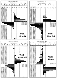 |
Figure 119. Examples of magnetometer records show intense magnetic anomalies at the shallow well sites. Casing left in the bedrock causes the anomalies. The well bores lie beneath the points at which the field intensity changes sign. [larger version] |
The study found that, at each site examined, measurable environmental perturbation varied and was limited to mechanical effects (Table 10). The effects on the benthic communities are described here as they existed in 1988.
- Well Site D/E-1: Two wells were drilled adjacent to each other on the southeast side of the Marquesas Keys (Fig. 117; Benthic Ecosystems for Tile 9). A floating barge drilled the first one at site D in 1961 (Table 9). The effort was abandoned due to drilling problems and inclement weather. A year later, many tons of golf ball-size pea gravel were dumped to level the bottom and create a drill pad for the pontoon rig used to drill site E-1. The pea gravel covered ~1 acre of seabed plus the site D well bore (Fig. 120A, 120B). When the well at site E-1 was plugged and abandoned, more than 100 bags of cement were discarded around the bore.
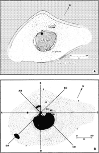 Figure 120. Well site D/E-1 (from Dustan et al., 1991). (A) Map of biological communities was derived from a census assessment along eight transects radiating from the main (>100) cement-bag pile (large black dot). Smaller pile of 8 to 10 bags lay northeast of the main pile. Well E-1 was thought to be under the main pile and well D under the pea-gravel drill pad south of E-1. Mostly exposed Pleistocene bedrock populated by gorgonians, sponges, and scattered corals surrounded the drill sites. Sea grasses grew in local sediment-filled depressions throughout the area. (B) Pea gravel and/or sediment thickness (in cm) was determined from probes taken along the radial-transect lines. Area near the center was >150 cm thick. Small bulls eye southwest of site was a local sediment-filled bedrock depression. [larger version]
 |
The 1988 study found four distinct, concentric bottom habitats: a central cement-bag habitat; pea gravel; sea grass; and a peripheral natural hardbottom (Fig. 121A, 121B, 121C, 121D). The cement bags had created a stable hardbottom that served as an artificial reef for colonization by macroalgae (~41% coverage) and coral (12 reef-building species, ~26% coverage). The resultant geometric complexity had increased fish diversity, in marked contrast to low diversity and numbers of fish in the surrounding pea-gravel, seagrass, and natural hardbottom gorgonian communities. Gorgonians and large sponges had not colonized the bags. Their absence was thought to result from fish predation (fish were observed nipping at the bags) or leachates emanating from the cement. Fleshy algae dominated the pea-gravel habitat. A seagrass community populated finer-grained sands at the perimeter of the pea gravel. The natural hardbottom gorgonian community also included sponges, corals, and assorted small reef fishes. Site D/E-1 had the largest area of the seven sites affected by drilling because of the dumped pea gravel and cement bags.
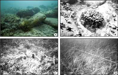
Figure 121. Well site D/E-1 (from Dustan et al., 1991). (A) Submerged cement bags. Note fish, including large red grouper, encrusting stinging coral (Millepora spp.), and large anemone in foreground. Golf ball-size pea gravel under cement bags is visible in right foreground. (B) Closeup of cement bags shows encrusting Millepora spp. (to left) and colony of coral Oculina diffusa (center). Small fish are predominantly wrasses and juvenile grunts. (C) Fleshy macroalgae (Laurencia spp.) cover pea gravel surrounding cement bags. Pre-1983 sea urchin (Diadema antillarum) die-off photos showed area then was relatively barren of algae. Ten-cm-long handle near center is for scale. (D) Syringodium spp. and Thalassia spp. seagrass community as seen along radial-transect line away from cement-bag pile. Substratum was mostly natural sediment with an admixture of pea gravel. Community distribution is shown in Figure 120A. [larger version] |
- Well Site 826Y: The drill site northeast of the Marquesas Keys (Fig. 117; Benthic Ecosystems for Tile 9) was a nearly featureless habitat in 5 m of water (Table 9) subjected to the exceptionally strong tidal currents that keep Boca Grande Channel free of sediment (Shinn et al., 1990). Murky water and rippled, shifting sand had discouraged development of an obvious biological community. Several tons of drilling debris (Fig. 122A, 122B) and limestone core, however, had created an artificial-reef effect. Three species of coral and numerous species of fleshy algae encrusted the debris.
 | Figure 122. Well site 826Y (from Dustan et al., 1991). (A) Large piece of drilling debris encrusted with sponges and algae. Triggerfish emerges from interior of pipe while diver uses underwater video camera in right background. Note murky water. Visibility at well site was <3 m. (B) Short length of casing and other algae-encrusted debris. Debris was concentrated over an area ~30 m in diameter with a few scattered bits extending as far as 40 m from center of pile. Site was surrounded by several centimeters of rippled carbonate sand over smooth Pleistocene bedrock. [larger version] |
- Well Site A: Well sites A, C, and B are located in 11 to 20 m of water (Table 9) along the shelf edge southwest of the Marquesas Keys (Fig. 117), where coral growth is marginal (Jaap, 1984). The paucity of reef development has been attributed to sporadic intrusion of cold Gulf of Mexico waters (Shinn, 1988; Shinn et al., 1989b). Winter storms and hurricanes also impact the area. A jackup rig supported on 14 legs drilled site A on a low-relief coral reef hardbottom flushed by strong tidal currents (Fig. 123A). Each leg and the borehole conductor pipe were fitted with a 4.5-m-diameter footpad that crunched into the reef. The 15 sand-filled footprints were clearly visible from the air in 1988 (Fig. 123B), 28 years after drilling (Table 9). The total area made unsuitable for corals and/or gorgonians by the legs and wellhead amounted to 242 m2, or roughly 6% of an acre. The generally small size of most corals on the reef was inferred to indicate that either they post-dated drilling or the reef suffered periodic mortality. However, 25 species of coral and 18 species of gorgonians clearly post-dated drilling in that they had developed on drilling debris surrounding the sand-filled depressions (Fig. 124A, 124B). Algae and 1-m-high brown barrel sponges (Xestospongiae spp.) also encrusted the debris (Fig. 124C).
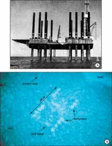 Figure 123. Well site A. (A) Offshore Company Rig 52 drilling well A for Gulf Oil Company in 1960. Note drill derrick over well bore at right. Also note drill mud and rock cuttings being dumped into water at right. Quadrat A-1 was located beneath area of drilling effluents. Photo is courtesy of the Oil and Gas Journal. (B) Low-level oblique aerial photograph taken in 1988 shows 14 sand-filled footprints, wellhead, and an anchor-chain scar (from Dustan et al., 2001). The anchor chain holding a marker buoy had made 360° sweeps of the bottom in heavy weather, completely scouring the bottom free of live corals. The bare zone was ~15 m in diameter. The amount of anchor-chain destruction implies that damage by support vessels may be greater than that caused by the drill platform (Dustan et al., 1991). Area at right is carbonate sand that lacked coral or gorgonian growth. [larger version] Figure 123. Well site A. (A) Offshore Company Rig 52 drilling well A for Gulf Oil Company in 1960. Note drill derrick over well bore at right. Also note drill mud and rock cuttings being dumped into water at right. Quadrat A-1 was located beneath area of drilling effluents. Photo is courtesy of the Oil and Gas Journal. (B) Low-level oblique aerial photograph taken in 1988 shows 14 sand-filled footprints, wellhead, and an anchor-chain scar (from Dustan et al., 2001). The anchor chain holding a marker buoy had made 360° sweeps of the bottom in heavy weather, completely scouring the bottom free of live corals. The bare zone was ~15 m in diameter. The amount of anchor-chain destruction implies that damage by support vessels may be greater than that caused by the drill platform (Dustan et al., 1991). Area at right is carbonate sand that lacked coral or gorgonian growth. [larger version] |
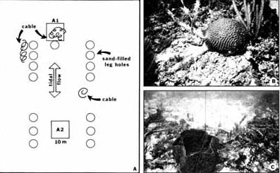
Figure 124. Well site A (from Dustan et al., 1991). (A) Diagram shows location of drill-rig footprints, census quadrats A1 and A2, tidal-flow directions, and distribution of debris that consisted mainly of discarded cable. Footprints were 4.5 m in diameter. Quadrat A-1 was down current, adjacent to sand hole around well bore, and included cable debris. Control quadrat A-2 contained no debris, was also down current on a reversed tide, and would have been under the rig platform, where organisms would have been subject to both drill effluents and shade. Bottom was flat. (B) Brain coral grew on intersection of two pieces of cable within quadrat A-1. Cable diameter is 5 cm. (C) Large barrel sponge grew on cable debris in quadrat A-1. View is toward circular sand-filled hole in background that conceals buried well bore. Video camera lies in sand hole. Vertical black line attached to piece of cable was tied to marker buoy. [larger version] |
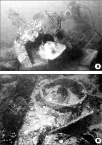
- Well Site C: The same jackup rig that drilled site A was used to drill site C west of site A (Table 9), but no footprints were discernable in the coarse carbonate sand. A few fleshy algae occupied the sand bottom. Only a partially buried cement cube used for a marker buoy and a conductor-pipe casing marked the site (Fig. 125A). Both were encrusted with macroalgae, sponges, and corals (Fig. 125B, 125C, 125D), and the pipe provided cover for fish and lobsters. Sediment movement at the high-energy site accounted for absence of discernable rig footprints and lack of other visible debris.
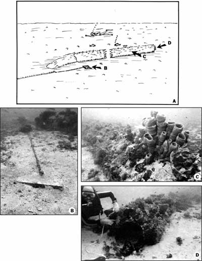
Figure 125. Well site C (from Dustan et al., 1991). (A) Sketch of 23-m-long conductor-pipe casing. Well bore is at left, where pipe bends into bottom. Arrow directions indicate view angles of underwater photographs. Clumps of brown fleshy algae littered the surrounding sandy bottom. (B) Cement cube with chain and nylon line attached. Note fleshy algae growing on chain and line. Conductor pipe is at upper right. (C) View of sponges and other encrusting organisms on pipe. (D) View of cut end of 91-cm-diameter conductor pipe shows 51-cm-diameter inner casing. The annulus between both pipes was filled with cement. Diver points at cement, visible only after dislodging encrustations with hammer. Pipe contained lobsters and fish. Large sea anemone lived in annulus at right side of pipe. [larger version] |
- Well Site B: The westernmost drill site on the Florida reef tract (Fig. 117; Table 9), site B was drilled on a rugged-relief, reasonably well developed reef knoll that supported gorgonians, fish, algae, and 17 coral species. The bottom community was typical of those usually found on Florida Keys coral reefs. Anchors had been used to hold in place the same floating rig that had drilled site D. Because of the spread needed for the 20-m water depth, the anchors were placed in the deeper sandy plain surrounding the knoll and therefore had had minimal impact on the knoll itself. Had the knoll been larger, the anchors would have been placed on coral bottom and damage would have been greater. Two conductor pipes (Fig. 126A) and other scattered debris marked the site. Montastrea caverosa, M. annularis, and gorgonians encrusted the pipes (Fig 126B). The debris had not increased fish diversity relative to that on the surrounding rugged reef. Corals were larger at site B than at site A, but the number of species was fewer, possibly an effect of deeper water (20 m) at site B than at site A (11 m). Site B is located beyond the elevated Marquesas-Quicksands ridge (Fig. 117) and thus is more prone to flushing by Gulf of Mexico coastal waters than is site A. The shallow (largely <6 m), 30-km-long, west-trending ridge (Shinn et al., 1990) offers site A some degree of protection from Gulf waters.
 | Figure 126. Well site B (from Dustan et al., 1991). (A) Length of 91-cm-diameter conductor pipe lying on crest of coral knoll. A longer length of casing was located about 50 m away. (B) Montastrea cavernosa (left) and M. annularis (right) growing on pipe in (A). Note abundance of gorgonians in both photos. [larger version] |
- Well Site G4950: The study that examined the shallow well sites in the keys via snorkeling and use of scuba gear (Shinn et al., 1989a) also examined deep-water well sites G4950 and G3906 west of Ft. Myers off west-central Florida (Fig. 118, Tables 9, 10; Dustan et al., 1991; Shinn et al., 1993). At those sites, a two-person submersible with a sample-collecting arm was used. The submersible was launched from a research vessel that maintained position at the latitude and longitude of the well sites. Although the deep sites are not located on the Florida reef tract, they are included in this report for contrasts: of water depths, benthic settings, field methods, debris fields, and drilling technology vs. circumstances surrounding the shallow sites. The shallow-water wells were drilled in 1959, 1960, 1961, and 1962 using now-outdated technology and prior to current MMS and OCS drilling restrictions and regulations. The deep-water wells were drilled in 1981 and 1986 using modern technology under strict MMS/OCS regulations. These studies are also important in light of the current renewed interest in drilling for oil and gas in the Gulf of Mexico.
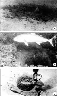
Site G4950 was located on a flat sandy bottom in turbid water 70 m deep (Table 9) and was found by following several large amberjack and a dense school of small silver fish that were attracted to the well bore. The bottom was littered with drilling debris consisting of a length of yellow pipe, a piece of yellow steel grate decking, a chair, two plastic buckets, a large pipe wrench, a short piece of coiled hose, and hundreds of used welding rods (Fig. 126A). A donut-shape mound of grout used to cement casing surrounded the wellhead. Currents had scoured one side of the inner edge of the mound. The grout had obliterated a community of coralgal nodules and plates, red and green algae, starfish, and sponges for a distance of 10 to 15 m around the well bore (Fig. 127B, 127C, 127D). Drilling operations and debris had disrupted the community an additional 10 m beyond (Fig. 127E). A lightweight transect chain deployed by the submersible easily disturbed the organisms, indicating community fragility. Sponges and algae dislodged during drilling had collected in a pit and long furrow, possibly made by a dragging anchor that may not have been related to the drilling operation. Well site G4950 was the youngest (2 years old) and deepest (70 m) examined in the 1988 study. A well depth of 3,216 m (Table 9) should have produced several thousand barrels of cuttings (Dustan et al., 1991), but no cuttings pile was found. Tidal currents had apparently dispersed the cuttings before they reached the bottom.
 Figure 127. Well site G4950 (from Dustan et al., 1991). (A) Sketch of site in 70 m of water shows approximate position of various debris objects. A long furrow led from a 60-cm-deep pit at lower right. Dashed line shows approximate limit of zone of visual disturbance. (B) View of disrupted bottom community consisting mainly of red algal nodules and plates. The green alga Caulerpa spp. was common. The submersible measuring chain (at right), composed of 1-cm-long links formed from 1-mm-diameter wire, accidentally dragged laterally (left to right) and disrupted the surface community. Community at top left was undisturbed. (C) View of cement donut or grout mound around well bore. Red grouper hovers over open hole; smaller one swims outside with numerous small silver fish. Both groupers repeatedly disappeared and reemerged from well bore. View is of scoured side of donut grout mound, at right in (A). (D) Closeup of vertical hole of well bore in bedrock. (E) View of pipe at right in (A). [larger version] Figure 127. Well site G4950 (from Dustan et al., 1991). (A) Sketch of site in 70 m of water shows approximate position of various debris objects. A long furrow led from a 60-cm-deep pit at lower right. Dashed line shows approximate limit of zone of visual disturbance. (B) View of disrupted bottom community consisting mainly of red algal nodules and plates. The green alga Caulerpa spp. was common. The submersible measuring chain (at right), composed of 1-cm-long links formed from 1-mm-diameter wire, accidentally dragged laterally (left to right) and disrupted the surface community. Community at top left was undisturbed. (C) View of cement donut or grout mound around well bore. Red grouper hovers over open hole; smaller one swims outside with numerous small silver fish. Both groupers repeatedly disappeared and reemerged from well bore. View is of scoured side of donut grout mound, at right in (A). (D) Closeup of vertical hole of well bore in bedrock. (E) View of pipe at right in (A). [larger version] |
- Well Site G3906: Site G3906 was located in 53 m of water (Table 9) in a flat coral-sponge community that inhabited an area of apparent karstic limestone with intermittent 5- to 20-m-wide outcrops 15 to 30 cm high. A thick fauna consisting mostly of sponges harboring numerous tropical fish encrusted the outcrops. The well bore, a vertical 1-m-wide hole in the center of an outcrop (Fig. 128A), was home to a large grouper, amberjacks, and schools of small silver fish (Fig. 128B). Drilling debris was less apparent than at site G4950 and impacted an area ~50 m in diameter. Debris consisted of metal scraps, small pieces of hose, a few welding rods, monofilament fishing line, and a 2-m-long sheet of corrugated steel roofing (Fig. 128C). Because the site was 5 years older than site G4950, corrosion may have eliminated many of the welding rods and small metal scraps. Sponge- and sand-covered bedrock surrounded the well bore, which lacked a grout mound. Rippled sand indicated presence of high-energy currents that were not apparent at site G4950. There was no indication of permanent damage other than the hole in the bedrock that provided an "island" oasis for fish.
 | Figure 128. Well site G3906 (from Dustan et al., 1991). (A) View of well bore in 53 m of water shows black grouper (at left) and large (~30 kg, or 66 lb) grouper peering out of bore. Dark area is naturally occurring rock through which well was drilled. Surrounding bottom has no algal community. Crest of sand ripple visible in lower left corner. (B) View into well bore below large amberjack, part of a school patrolling the area. (C) Piece of metal debris in submersible claw near well bore. [larger version] |
Shinn and Lidz (1992) and Shinn et al. (1993) similarly evaluated impacts of six exploratory wells drilled in the northeastern Gulf of Mexico between 1972 and 1990. Water depths ranged from 21 to 149 m. Bottom sediments varied from carbonate mud to shelly quartz sand and silt to hard limestone. The time between cessation of drilling activities at those sites and evaluation was 15 months to 17 years.
As in the 1988 study, Shinn and Lidz (1992) and Shinn et al. (1993) found that time is the single most important factor determining the nature of habitat recovery. Impacts, such as the extent of debris, affected the bottom in areas ranging from nearly negligible (17-year-old site) to as much as 3 acres (4-year-old site). Those sites with the most debris and/or open boreholes had attracted the most abundant and diverse fish fauna (Table 10).
The major conclusion reached in those studies (Shinn et al., 1989a; Dustan et al., 1991; Shinn and Lidz, 1992; Shinn et al., 1993) was that the exploratory drilling had minimal impact on the benthic environment. With careful placement of the rig or anchors on a sand bottom and if no plastic or metal debris were discarded, only a well bore would be left after time. The well bore would eventually fill with sand, leaving a magnetic anomaly to mark the spot. These conclusions pertain only to exploratory wells and cannot be used to draw conclusions concerning potential ecological impact of production wells on marine communities.
continue to: Geologic Highlights
|


