USGS - science for a changing world

FISC - St. Petersburg

Coastal & Marine Geology Program > Center for Coastal & Watershed Studies > Professional Paper 1751

Systematic Mapping of Bedrock and Habitats along the Florida Reef Tract—Central Key Largo to Halfmoon Shoal (Gulf of Mexico)

USGS Professional Paper 1751

by Barbara H. Lidz, Christopher D. Reich, and Eugene A. Shinn

Introduction:
Table of Contents
Project Overview
Project Objective
Geologic Setting
Primary Datasets
Primary Products - Overview Maps & Evolution Overview:
Bedrock Surface map.
Introduction
Depth to Pleistocene Bedrock Surface
Reef & Sediment Thickness
Benthic Ecosystems & Environments
Sedimentary Grains in 1989
Summary Illustration Index Map
Evolution Overview
Tile-by-Tile Analysis
Satellite image of the Florida Keys showing location of tiles.
Organization of Report
Tiles: 1, 2, 3, 4,
5, 6, 7/8, 9/10,
11
Summary
Acknowledg-
ments
References
Disclaimer
Related
Publications

Tile 9/10

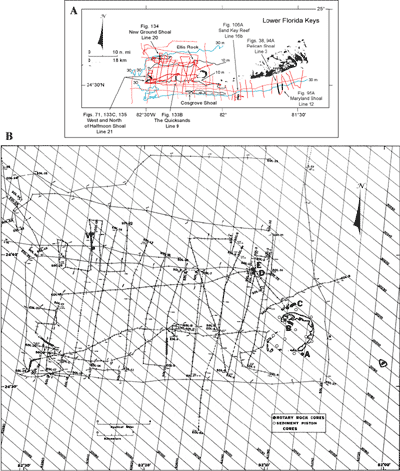
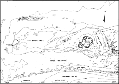
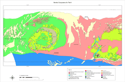
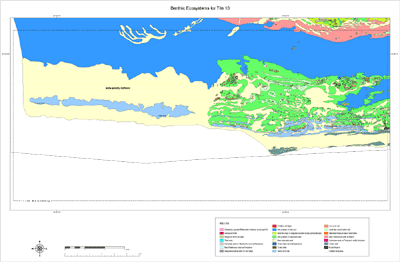
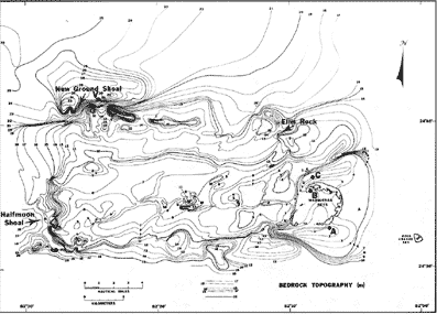
Boca Grande Key, Boca Grande Channel, and the Marquesas Keys: Extensive geophysical data have been collected along the Florida shelf west of the Marquesas Keys (Figs. 129A, 129B; Shinn et al., 1990). Area bathymetry indicates the presence of a westward-oriented ridge in roughly the shape of a rectangle ~10 km wide by 30 km long (Fig. 130). The ridge is elevated 10 to 20 m above the shelf proper, and its south side is 8 to 10 km from the shelf margin bordering the Straits of Florida (see Bedrock Surface map). Boca Grande Channel and the Marquesas Keys (Tile 9) mark the east end of the ridge with Boca Grande Key located on the east side of the channel. Cosgrove Shoal and Coalbin Rock (Tile 10) lie seaward at the shelf margin (Fig. 115C). Sediments of The Quicksands (Tile 11) overlie the ridge.

(A) Index map shows tracklines of U.S. Geological Survey seismic data. (B) Closeup of seismic tracklines in the Marquesas-Quicksands ridge area.
Figure 129. (A) Index map shows tracklines (red) of USGS seismic data acquired in the lower Florida Keys/Gulf of Mexico area and those portions selected (bold black) for illustration with their figure numbers (modified from Lidz et al., 2003). Shelf-margin contour is in blue; contours are in meters. (B) Closeup of seismic tracklines in the Marquesas-Quicksands ridge area (Fig. 130; from Shinn et al., 1990). Bold sections of tracklines indicate areas of pictured seismic data, as shown in (B). Most tick marks on tracklines are at 5-min intervals. Dashed lines indicate travel time without data collection. SOL = start of line. EOL = end of line. V = vibracore site. [larger version]

Bathymetry derived from navigation charts in area of The Quicksands, Gulf of Mexico, shows locations of major navigational markers and reefs
Figure 130. Bathymetry derived from navigation charts in area of The Quicksands, Gulf of Mexico, shows locations of major navigational markers and reefs (from Shinn et al., 1990). The Marquesas-Quicksands ridge is demarcated by the 30-ft depth contour (10-m bedrock contour in Fig. 131 and on Bedrock Surface map). For navigational purposes, bathymetric data should be considered inaccurate in areas of shifting sands. [larger version]

Boca Grande Key west of Key West is the largest of several islands between Key West and the Dry Tortugas (Figs. 6A, 77C). Only two (Garden and Loggerhead Keys in the Tortugas) are inhabited. Boca Grande Key marks the southeast edge of a northward-trending bedrock depression beneath Boca Grande Channel (see Benthic Ecosystems for Tile 9 and Tile 10). The depression ranges from 4.5 to 6 m below sea level and separates the broad higher-elevation areas occupied by the lower Florida Keys and The Quicksands. Strong reversing tidal currents keep the channel free of sediment (Shinn et al., 1990; see Sediment Thickness map). The channel is thus a barrier to westward movement of sediment generated in the lower Keys to the east. The Marquesas Keys, an atoll-like ring of sand-spit islands consisting of mangrove-covered, Halimeda-rich sand (Hudson, 1985), are located on the west side of Boca Grande Channel, at the east end of The Quicksands. Probing to bedrock showed the island ring developed on top of two narrow, parallel, westward-oriented, bedrock-high ridges 1 to 2 m below sea level (Fig. 131; also see Bedrock Surface map). Hook-shaped spits at the northwestern end of the islands indicate accretion is to the west. The vegetated ring of islands acts as a wave-and-current barrier, producing a low-energy trap that allows accumulation of fine-grained sediments in its interior ovoid-shaped swale.

Benthic Ecosystems for Tile 9
Benthic Ecosystems for Tile 9 [larger version]

Benthic Ecosystems for Tile 10
Benthic Ecosystems for Tile 10 [larger version]

Contour map of bedrock depth (relative to present sea level) shows the Marquesas-Quicksands ridge is elevated above surrounding bedrock surfaces
Figure 131. Contour map of bedrock depth (relative to present sea level) shows the Marquesas-Quicksands ridge is elevated above surrounding bedrock surfaces (from Shinn et al., 1990). The ridge is bounded on the north by the Key West Shrimping Grounds, on the east by Boca Grande Channel, on the south by the westward extension of the bedrock depression below Hawk Channel, and on the west by an unnamed bedrock channel (see Bedrock Surface and Benthic Ecosystems maps). A, B, C = rotary rock core sites; V = vibracore site. [larger version]

Three rotary rock cores taken at the Marquesas Keys showed that bedrock consists of the same oolite that formed the lower Florida Keys (Shinn et al., 1990). However, beneath and south of the islands (Fig. 129B, cores A, B), the oolite is non-bedded and highly burrowed, whereas north of the islands (core C), it is cross-bedded and non-burrowed. The cross-bedded zone trends eastward for at least 65 km, forming the northern margin of the lower Florida Keys, and is thought to represent a Pleistocene beach deposit (Shinn et al., 1990).

Coastal & Marine Geology Program > Center for Coastal & Watershed Studies > Professional Paper 1751

Accessibility FOIA Privacy Policies and Notices

Take Pride in America logo USA.gov logo U.S. Department of the Interior | U.S. Geological Survey
URL: [disc] /pubs/pp/2007/1751/professional-paper/tile9-10/boca-grande.html
Page Contact Information: Feedback
Page Last Modified: December 01, 2016 @ 04:15 PM (JSS)