Skip header
 Identifier symbol and link to USGS Home page
Oceanographic Observations, Hudson Shelf Valley, U.S. Geological Survey Open-File Report 02-217

Digital Data Files


Included in this report are digital data obtained from the tripods and moorings, the Acoustic Backscatter system (ABS), and hydrographic data.

Tripod/Moorings

ABS

Hydrographic

Tripod/Moorings:

The data format is the EPIC NetCDF standard defined by the NOAA Pacific Marine Environmental Laboratory (PMEL). NetCDF is a very general, self-documenting, machine-transportable data format created and supported by UCAR (www.unidata.ucar.edu/packages/netcdf/). EPIC (www.pmel.noaa.gov/epic/) is a set of standards which allow researchers from different organizations to share oceanographic data without having to translate "foreign" data types into the local vernacular.

NOTE: Depths in the NetCDF file headers differ slightly from those in the Table of instrumentation deployed. Users should use depths reported in Table.

The naming convention for NetCDF data files is as follows:
Click here for the alternative accessible version of the following chart:
4801Aspd-a1h_d1.cdf
4801A
spd
-a1h
_d1
.nc


_d1
_d2
etc

(optional) depth identifiers used when a single data logger records the same variables at different depths (requiring separate EPIC "time series" data files)
   

-a
-a1h
-alp
-m
-m1h

best basic version
hour averaged best basic version
low-pass filtered best basic version
merged basic versions
merged then hour averaged

  spd or s
v
tct
p
psd
var
ox
cst
t
tc
tcp
att or ats
pct
adc
vm
sc
mc
(none)
velocities corrected for speed of sound
velocities (averaged or basic time step)
temperature, conductivity, transmission
pressure (averaged or basic time step)
pressure standard deviation
variances and covariances of velocity
oxygen
conductivity, salinity, temperature
temperature
temperature, conductivity
temperature, conductivity, pressure
transmission and attenuation
pressure, conductivity (salinity), transmission
all ADCP variables
all VMCM variables
all SEACAT variables
all MicroCAT variables
all data from this data logger
Traditional data identifier First three digits identify moorings chronologically. Fourth digit identifies data loggers sequentially from top.Capital letter suffix (optional) identifies data subsets.

Basic Sampling Interval, Hourly Averaged,
Low-Passed Data (NetCDF)

Basic Sampling Interval, Hourly Averaged,
Low-Passed Data (Matlab)

Hourly Averaged & Low-Passed Data (ASCII)

Suspended sediment concentrations from time-series sediment sampler

ABS Data

Only data from the 2.5 Mhz sensors are included in this report as this frequency provides the best comprise between sensitivity to the fine sediment and low sediment induced attenuation. 3-frequency inversions for particle size were not performed due to the fine sediment size, which is in the Raleigh scattering regime for all frequencies.

All time stamps are in decimal days referenced to 1/1/2000 0:00:00 GMT and are stored in vectors sync_time_ABS_A or B. Bottom elevations were estimated from the maximum bed echo and are includes as vectors sync_botloc_ABS_A or B. Concentration water estimates (in grams sediment /liter) from the 2.5 Mhz data in 128 range bins (plus one header for 129 points) are in the matrices sync_cal_conc25_ABS_A or B. The distance from the transducer is located in vector zt. A second set of matrices sync_cal_conc25_ABS_A_zref are also included that are referenced to bed elevation as opposed to the distance from the transducer. These were created by shifting the vertical reference using the estimated seafloor location contained in the botloc time series.

Acoustic Backscatter (Matlab - Single File)

Jump to top of page

Hydrographic Data:

Profiles of conductivity, temperature, depth and other variables were obtained on the RV Oceanus and RV Endeavor cruises. Configuration files for each Seasoft program used to process the data are included in a zip file, along with the batch job to run all individual programs for a particular cast. Also included are the original data files (.dat), the ascii header files (.hdr) containing all processing information, and an ascii output file of the data after having been processed with the steps above; the bottle files for each cast contain the same information as the ascii output files for those depths where Niskin bottles were fired. For each cruise, there is also a matlab file containing all of the data, sorted by cast, with the same columns as described in the header files. For each cast on the RV Endeavor cruise, there is also a data configuration (.con) file used by datcnv to calibrate the data; there is one single configuration file for all casts on the RV Oceanus cruise.

RV Oceanus Cruise:

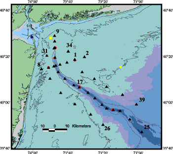
Map of Cast Locations:

Map of Oceanus cruise cast locations.

Excel file of suspended sediment concentrations from filtered water samples: oc_sed_and_optical.xls

Zip file containing all program configuration files: oc_process.zip

Data configuration file: OC354.con

Matlab file with all CTD data: oc_ctd_mat.mat


Header ASCII File Raw Data Bottle Files
1 OC354001.hdr OC354001.asc OC354001.dat OC354001.btl
2 OC354002.hdr OC354002.asc OC354002.dat OC354002.btl
3 OC354003.hdr OC354003.asc OC354003.dat OC354003.btl
4 OC354004.hdr OC354004.asc OC354004.dat OC354004.btl
5 OC354005.hdr OC354005.asc OC354005.dat OC354005.btl
6 OC354006.hdr OC354006.asc OC354006.dat OC354006.btl
7 OC354007.hdr OC354007.asc OC354007.dat OC354007.btl
8 OC354008.hdr OC354008.asc OC354008.dat OC354008.btl
9 OC354009.hdr OC354009.asc OC354009.dat OC354009.btl
10 OC354010.hdr OC354010.asc OC354010.dat OC354010.btl
11 OC354011.hdr OC354011.asc OC354011.dat OC354011.btl
12 OC354012.hdr OC354012.asc OC354012.dat OC354012.btl
13 OC354013.hdr OC354013.asc OC354013.dat OC354013.btl
14 OC354014.hdr OC354014.asc OC354014.dat OC354014.btl
15 OC354015.hdr OC354015.asc OC354015.dat OC354015.btl
16 OC354016.hdr OC354016.asc OC354016.dat OC354016.btl
17 OC354017.hdr OC354017.asc OC354017.dat OC354017.btl
18 OC354018.hdr OC354018.asc OC354018.dat OC354018>.btl
19 OC354019.hdr OC354019.asc OC354019.dat OC354019.btl
20 OC354020.hdr OC354020.asc OC354020.dat OC354020.btl
21 OC354021.hdr OC354021.asc OC354021.dat OC354021.btl
22 OC354022.hdr OC354022.asc OC354022.dat OC354022.btl
23 OC354023.hdr OC354023.asc OC354023.dat OC354023.btl
24 OC354024.hdr OC354024.asc OC354024.dat OC354024.btl
25 OC354025.hdr OC354025.asc OC354025.dat OC354025.btl
26 OC354026.hdr OC354026.asc OC354026.dat No Bottles
27 OC354027.hdr OC354027.asc OC354027.dat No Bottles
28 OC354028.hdr OC354028.asc OC354028.dat No Bottles
29 OC354029.hdr OC354029.asc OC354029.dat No Bottles
30 OC354030.hdr OC354030.asc OC354030.dat OC354030.btl
31 OC354031.hdr OC354031.asc OC354031.dat OC354031.btl
32 OC354032.hdr OC354032.asc OC354032.dat OC354032.btl
33 OC354033.hdr OC354033.asc OC354033.dat OC354033.btl
34 OC354034.hdr OC354034.asc OC354034.dat No Bottles
35 OC354035.hdr OC354035.asc OC354035.dat OC354035.btl
36 OC354036.hdr OC354036.asc OC354036.dat OC354036.btl
37 OC354037.hdr OC354037.asc OC354037.dat No Bottles
38 OC354038.hdr OC354038.asc OC354038.dat No Bottles
39 OC354039.hdr OC354039.asc OC354039.dat No Bottles

Jump to top of page

RV Endeavor Cruise:

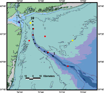
Map of Cast Locations:

Map of Endeavor cruise cast locations.

Excel file of suspended sediment concentrations from filtered water samples: Endeavor

Zip file containing all program configuration files: en_process.zip

Data configuration files:
CTD01.con
, CTD02.con, CTD03.con, CTD04.con, CTD05.con, CTD06.con, CTD07.con, CTD08.con, CTD09.con, CTD10.con

Matlab file with all CTD data: en_ctd_mat.mat

  Header ASCII File Raw Data Bottle Files
1 CTD01.hdr CTD01.asc CTD01.dat No Bottles
2 CTD02.hdr CTD02.asc CTD02.dat CTD02.btl
3 CTD03.hdr CTD03.asc CTD03.dat CTD03.btl
4 CTD04.hdr CTD04.asc CTD04.dat CTD04.btl
5 CTD05.hdr CTD05.asc CTD05.dat CTD05.btl
6 CTD06.hdr CTD06.asc CTD06.dat CTD06.btl
7 CTD07.hdr CTD07.asc CTD07.dat CTD07.btl
8 CTD08.hdr CTD08.asc CTD08.dat CTD08.btl
9 CTD09.hdr CTD09.asc CTD09.dat CTD09.btl
10 CTD10.hdr CTD10.asc CTD10.dat CTD10.btl

Time Series Sediment Sampler

Excel file contaiming sediment concentrations from Time Series Sediment Sampler deployed at Site A. See instrumentation for a description of the sampling scheme used in this deployment.

Jump to top of page

Go to previous page.     Go to next page.

To view files in PDF format, download free copy of Adobe Acrobat Reader (www.adobe.com/products/acrobat/alternate.html).


Skip footer information
Title Page / Contents / Tables / Figures / Abbreviations / Introduction / Field Program / Observations / Instrumentation / Data Processing / Fouling / Mooring/Data File ID / Results / Digital Data / Acknowledgements / References / Matlab / Supplementary / Metadata
[an error occurred while processing this directive]