USGS - science for a changing world

FISC - St. Petersburg

Coastal & Marine Geology Program > Center for Coastal & Watershed Studies > Professional Paper 1751

Systematic Mapping of Bedrock and Habitats along the Florida Reef Tract—Central Key Largo to Halfmoon Shoal (Gulf of Mexico)

USGS Professional Paper 1751

by Barbara H. Lidz, Christopher D. Reich, and Eugene A. Shinn

Introduction:
Table of Contents
Project Overview
Project Objective
Geologic Setting
Primary Datasets
Primary Products - Overview Maps & Evolution Overview:
Bedrock Surface map.
Introduction
Depth to Pleistocene Bedrock Surface
Reef & Sediment Thickness
Benthic Ecosystems & Environments
Sedimentary Grains in 1989
Summary Illustration Index Map
Evolution Overview
Tile-by-Tile Analysis
Satellite image of the Florida Keys showing location of tiles.
Organization of Report
Tiles: 1, 2, 3, 4,
5, 6, 7/8, 9/10,
11
Summary
Acknowledg-
ments
References
Disclaimer
Related
Publications

Tile 11

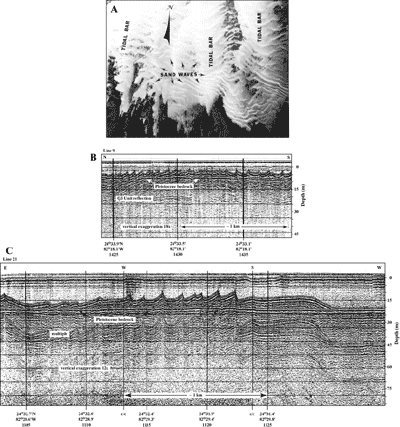
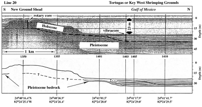
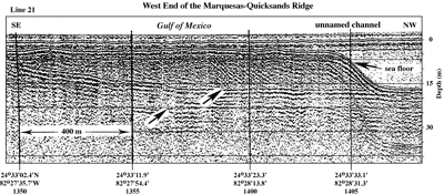
The Marquesas-Quicksands Ridge: Bathymetry on navigational charts (Fig. 130) and topography derived from ~640 line km of geophysical data collected in 1981, 1983, and 1989 (Shinn et al., 1990; Figs. 129A, 129B, 131) reflect a structural east-west orientation to the area called The Quicksands, west of the Marquesas Keys (Figs. 132A, 133A). The roughly rectangular bedrock ridge is marked by the 10-m (30-ft) depth contour and is ~10 km wide by 30 km long. Referred to as the Marquesas-Quicksands ridge (Shinn et al., 1990), the ridge is the westward extension of the limestone platform spit on which the chain of Florida Keys is located (see Bedrock Surface map). On the ridge, bedrock ranges from 1 to 12 m below sea level but is generally less than 6 m (Fig. 133B, 133C). Relatively deep (>20 m) waters bound the ridge on three sides—the Tortugas or Key West Shrimping Grounds to the north (Fig. 134), an unnamed channel to the west (Fig. 135), and a backreef lagoon to the south (the westward extension of the Hawk Channel bedrock depression; Fig. 6A). Intermittent patch reefs of head corals and gorgonians occur in the lagoon. The floor of Boca Grande Channel east of the ridge is much shallower (4.5 to 6 m) but is separated from similar depths on the ridge by elevated bedrock beneath the Marquesas Keys. Although the Tile 11 boundaries center on The Quicksands, seismic and core data extend outside the boundaries (Fig. 129B; see Bedrock Surface and Sediment Thickness maps).

aerial photo and seismic profiles
Figure 133. Aerial photo (pre-1990) and seismic profiles (1981) show the sand bedforms and flat Pleistocene bedrock surface that characterize much of The Quicksands in the Gulf of Mexico (from Shinn et al., 1990). (A) Tidal bars are oriented north-south. Sand waves are oriented east-west. Patterns of sand buildups are a response to strong north-south currents. Turtle sea grass (Thalassia testudinum) and various species of a calcareous green alga (Halimeda) populate the dark areas. Corals are absent. Distance across photo is approximately 2.5 km. (B) Seismic profile across middle part of The Quicksands (Fig. 129B) shows low-amplitude (~1 m high) sand waves on shallow (~5 m deep) bedrock. The prominent seismic reflection below the bedrock surface is the Q3 unconformity of Perkins (1977; Table 5). Comparison of photo in (A) with direction of seismic line in profile (B) shows the seismic line paralleled the tidal bars and crossed normal to the sand waves. Sand-wave reflections thus represent true (non-distorted) images. (C) Seismic profile across channel bottom west of Halfmoon Shoal (Fig. 129B) shows large, high-amplitude (~5 m high) asymmetric sand waves resting on deep (~20 m) bedrock. c/c indicates course change. The westernmost sand wave has been smoothed (distorted) by the ship's change in course. For sand-wave height and bedrock-depth comparison, depth scales in (B) and (C) match. Approximate lateral distance based on boat speed of 4 knots. 'Multiples' are an artifact common in seismic-reflection data. These reflections replicate those of existing, overlying, geologic surfaces and should not be regarded as representing any subsurface stratigraphic horizon. Latitude and longitude below vertical time lines on both profiles are given in degrees and decimal minutes based on Loran C TDs (Time Differences). Hours (military time) below coordinates serve as navigational correlation points along seismic line. [larger version]

Seismic profile and interpretation show geology across the reef at New Ground Shoal and into Key West Shrimping Grounds
Figure 134. Seismic profile and interpretation show geology across the reef at New Ground Shoal and into Key West Shrimping Grounds, an area of muddy carbonate sediment (see Fig. 129A for location; from Shinn et al., 1990). Rotary core drilled into New Ground Shoal showed underlying Pleistocene corals to be equivalent to those of the Key Largo Limestone of the middle and upper Florida Keys, though the corals were not dated. The fauna of the 8-m-thick Holocene section was similar to that of the Pleistocene and lacked branching corals. The vibracore taken north of the shoal penetrated 8 m of seafloor lime mud and fine carbonate sand lacking corals. Seaward-dipping reflections in area of vibracore were possibly caused by concentrations of mollusc shells, probably deposited by storms. Hours (military time) below vertical time lines on profile serve as navigational correlation points along seismic line. Latitude and longitude below interpretation are given in degrees and decimal minutes based on Loran C TDs (Time Differences). [larger version]

Seismic profile shows 12-meter-thick sand accumulation north of Halfmoon Shoal
Figure 135. Seismic profile shows 12-m-thick sand accumulation north of Halfmoon Shoal (the more northern of two profile segments in Fig. 129A; from Shinn et al., 1990). Sediment is migrating westward off the Marquesas-Quicksands ridge into deeper water. Left arrow = Pleistocene Q3 Unit of Perkins (1977). Right arrow = top of Pleistocene surface. Latitude and longitude below vertical time lines on profile are given in degrees and decimal minutes based on Loran C TDs (Time Differences). Hours (military time) below coordinates serve as navigational correlation points along seismic line. [larger version]

Bedrock on the ridge is relatively flat with numerous localized solution holes and depressions (Figs. 131, 133B, 133C, 135). As in the Florida Keys (e.g., Multer and Hoffmeister, 1968; Perkins, 1977; Robbin and Stipp, 1979), calcrete caps the ridge bedrock. A transect of three rotary rock cores drilled north, within, and south of the Marquesas Keys showed the bedrock was oolite at each core site (Shinn et al., 1990). Beneath and south of the islands (Fig. 129B, cores A, B), the oolite is non-bedded and highly burrowed. North of the islands (core C), the oolite is distinctly cross-bedded with no burrows. Cores A and C were drilled on two narrow parallel bare rock surfaces about 1 to 2 m below sea level (see Bedrock Surface map). Numerous 1- to 4-cm-high rock ridges oriented in an east-west direction ornamented the bottom at site C. Truncated, seaward-dipping (northward) accretionary cross-bedding created the ridges, which are believed to represent beach berms (Shinn et al., 1990). The zone of cross-bedded oolite forms the north edge of the Florida Keys (Shinn et al., 1989a). The submerged Key Largo Limestone is known from core borings to extend westward as far as the Dry Tortugas (Shinn et al., 1977a). Scattered hand samples of rock collected from the ridge indicate the oolite continues westward as well, probably as far as Halfmoon Shoal (Shinn et al., 1990). Though no radiometric ages have been obtained on bedrock from the ridge, the oolite is presumed to be the same age (~125 ka) as that of the lower Florida Keys.

Holocene dates have been obtained on overlying subsurface peat recovered from a site on the south-central side of the ridge and from a submerged in-situ Dade County slash pine tree stump at New Ground Shoal (Table 3; see Summary Illustration). Halimeda sands compose the crescentic islands of the Marquesas Keys (Hudson, 1985). The spit-like shape of the islands and their westward-trending extensions indicate that, like elsewhere on the ridge, sands of the islands are accreting westward.

Coastal & Marine Geology Program > Center for Coastal & Watershed Studies > Professional Paper 1751

Accessibility FOIA Privacy Policies and Notices

Take Pride in America logo USA.gov logo U.S. Department of the Interior | U.S. Geological Survey
URL: [disc] /pubs/pp/2007/1751/professional-paper/tile11/marquesas.html
Page Contact Information: Feedback
Page Last Modified: December 01, 2016 @ 04:13 PM (JSS)