USGS - science for a changing world

FISC - St. Petersburg

Coastal & Marine Geology Program > Center for Coastal & Watershed Studies > Professional Paper 1751

Systematic Mapping of Bedrock and Habitats along the Florida Reef Tract—Central Key Largo to Halfmoon Shoal (Gulf of Mexico)

USGS Professional Paper 1751

by Barbara H. Lidz, Christopher D. Reich, and Eugene A. Shinn

Introduction:
Table of Contents
Project Overview
Project Objective
Geologic Setting
Primary Datasets
Primary Products - Overview Maps & Evolution Overview:
Bedrock Surface map.
Introduction
Depth to Pleistocene Bedrock Surface
Reef & Sediment Thickness
Benthic Ecosystems & Environments
Sedimentary Grains in 1989
Summary Illustration Index Map
Evolution Overview
Tile-by-Tile Analysis
Satellite image of the Florida Keys showing location of tiles.
Organization of Report
Tiles: 1, 2, 3, 4,
5, 6, 7/8, 9/10,
11
Summary
Acknowledg-
ments
References
Disclaimer
Related
Publications

Tile 2

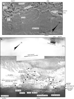
Tavernier Key: Tavernier Key is a nearshore mangrove island surrounded by a shallow bank (Fig. 48A, 48B). Like Rodriguez Key bank off Key Largo (Fig. 42B), Tavernier Key bank began to develop a few thousand years ago when sluggish water circulation in very shallow depths allowed mud to settle and collect in a concave bedrock indentation (Enos, 1983). Mud buildup continued with rising sea level, forming a mud bank that later developed a branching-coral (Porites) and coralline-algae (Goniolithon) rim. The solidified rim mostly lines the seaward side of the bank and protects the muddy mangrove island from incoming waves.

Photos show seabed features, habitat communities, and the effects of variable water-column conditionsFigure 48. Photos show seabed features, habitat communities, and the effects of variable water-column conditions in the Tile 2 sector of the upper Florida Keys (from Lidz et al., 2003; Fig. 42B, Table 2). (A) When water clarity allows, the nearshore rock ledge on the seaward side of the keys is visible, here in the area of Plantation Key and Tavernier Key bank. Photo taken in 1975. (B) Composite of two sets of photos. Top half, taken in 1991, highlights the common problem of turbidity and low visibility in Hawk Channel. Bottom half, taken in 1975, shows offshore sand blankets and sand waves on the outer shelf along with grassy areas and numerous patch reefs that overlie coral-rock ridges. The mosaic indicates that outlier reefs occur seaward of the shelf margin in this area, but they have not been recorded in seismic-reflection data for various reasons. (a) The photos were not available at the time of the seismic survey, so researchers were not aware of the outliers and could not survey them. (b) Not knowing the outliers were there, the researchers did not run the research vessel far enough offshore to record the longer ones. (c) Small, short outliers such as those to the left of the oval outlier marked for scale (~0.8 km) are difficult to record unless by chance due to strong offshore currents pushing the vessel off course. The oval outlier is noted on navigation charts. Note location of the underwater habitat Aquarius seaward of Conch Reef. [larger version]

At Rodriguez Key, the oldest conventional 14C date (Turmel and Swanson, 1976) on mangrove peat now under water but recovered in cores was calibrated to correlate with ages obtained using high-precision age-dating methods. Calibration yielded an age range of about 6,530 to 6,180 cal. yr B.P. (Table 3). The old mangroves grew along the mudbank shoreline and thus post-date the bank, indicating that Rodriguez Key bank is older than 6,530 cal. yr B.P. The bank around Tavernier Key is likely the same age.

Tavernier Key bank differs from Rodriguez Key bank by having a carbonate sand beach in its central axis. Sailors once obtained fresh water from the water lens in the sand [Romans, 1775 (1962)].

Seaward of Plantation and Tavernier Keys, the Pleistocene reef rimming the shelf margin remains a fairly continuous structure in the Tile 2 sector, extending southwestward from The Elbow (Fig. 33A, 33B). Numerous sand chutes mark unevenness of the reef crest. The first major breaks or reentrants visible in aerial photos of the reef occur on either side of Crocker Reef (Fig. 48B).

Coastal & Marine Geology Program > Center for Coastal & Watershed Studies > Professional Paper 1751

Accessibility FOIA Privacy Policies and Notices

Take Pride in America logo USA.gov logo U.S. Department of the Interior | U.S. Geological Survey
URL: [disc] /pubs/pp/2007/1751/professional-paper/tile2/tavernier.html
Page Contact Information: Feedback
Page Last Modified: December 01, 2016 @ 04:13 PM (JSS)