FISC - St. Petersburg
|
Tile 2
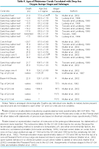
Conch Reef: Conch Reef, composed of Holocene corals on the Pleistocene shelf-edge reef, is located southeast of Tavernier Key (Fig. 42B). Nearly emergent at low tide, Conch Reef is ornamented with spurs and grooves (Fig. 48B). Spurs dip seaward and disappear in about 9 m of water, giving way to a channel 12 to 18 m deep that is filled with carbonate sand. The channel parallels the reef. Seaward of the channel is an outlier reef in ~16.5 m of water with scattered massive live head corals. The reef crest of the outlier rises to a water depth of about 12 m. This feature, like other outlier reefs along the margin, parallels the shallower, more landward, shelf-edge reef. On its seaward side, the outlier reef slopes to a depth of about 36.5 m, where it merges with sandy bottom that extends seaward for a kilometer or more before dropping off into the depths of the Florida Straits. Having the appearance of a typical coral reef, the outlier is ornamented with numerous gorgonians, large sponges, and scattered massive head corals up to 2 m high. Most of the surface is coated with turf algae. Radiometric dates on a 16.5-m-long USGS core drilled in 13.7 m of water on the seaward edge of the outlier revealed that the feature is Pleistocene (~87 ka, Table 5). The core penetrated to a depth of ~35 m below sea level and has ~15 cm of Holocene overgrowth on a calcrete or soilstone crust that caps the Pleistocene corals. The subaerially formed calcrete developed when the Pleistocene reef was exposed during the period of lowered sea level prior to about 7 ka. Designated as core AQ and described in Multer et al. (2002), the core is housed at the USGS facility in St. Petersburg, Florida.
An enclosed underwater habitat named the Aquarius rests in about 19 m of water in a sand patch within a rock depression along the crest of the outlier reef seaward of Conch Reef. The 16.5-m-long core was drilled adjacent to the Aquarius habitat. Located at 24°57'00'' N, 80°27'13'' W, the Aquarius is a self-contained facility in which as many as six divers can live under saturated conditions of ambient water pressure. The habitat was first deployed in Salt River Canyon on St. Croix, U.S. Virgin Islands, in 1988 and has been in operation off Conch Reef in the Florida Keys National Marine Sanctuary since 1992. Diving scientists, known as aquanauts, generally conduct 5- to 10-day-long projects from the habitat. The habitat supports as many as a dozen missions each summer. Numerous publications have resulted from observational biologic and geologic surveys based at the habitat. The University of North Carolina (Wilmington) operates the habitat for NOAA from an onshore facility on Key Largo. Extensive information on the habitat, its mission, research projects, and other comprehensive facts can be found on the Aquarius website. Particulars on the geology of the Conch Reef area can be found in Shinn et al. (1989a). Aronson et al. (1994) provide descriptions of benthic communities at Conch and Carysfort Reefs in the upper Keys. |

![]() U.S. Department of the Interior |
U.S. Geological Survey
U.S. Department of the Interior |
U.S. Geological Survey
URL: [disc] /pubs/pp/2007/1751/professional-paper/tile2/conch.html
Page Contact Information: Feedback
Page Last Modified: December 01, 2016 @ 04:13 PM (JSS)