FISC - St. Petersburg
|
Primary Datasets
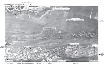
Aerial Photomosaics: Aerial photomosaics were used to interpret types of seafloor environments (Fig. 11). Mosaics were assembled by cropping 67 black-and-white overlapping frames of photos (1:48,000) taken in 1991 and 1992 by the National Ocean Service (NOS/NOAA/National Geodetic Survey) for the purpose of mapping shorelines along the Florida Keys. These mosaics supplemented those taken in 1975 by the Florida Department of Transportation to evaluate anthropogenic changes in the keys. The 1975 photos were used in the published photomosaic study (Lidz et al., 1997a). Interpretation of the new photomosaics was supported where necessary with color photos taken in 1983 for an inventory of seagrass and coral reef coverage by the U.S. Environmental Protection Agency (EPA). The EPA volume available to this project covered the reef tract from Sombrero Key south of Vaca Key to just west of Cosgrove Shoal, located south-southwest of the Marquesas Keys in the Gulf of Mexico (Fig. 6A).
Field visits and Global Positioning System data were used to groundtruth and geo-locate prominent features on each frame of the published photomosaic (Lidz et al., 1997a). Clearly identifiable points onshore and offshore were used to geo-rectify photomosaics along the rest of the reef tract. In all cases of aerial coverage, image distortion due to flight path and camera-lens curvature resulted in slight offset of overlapping features on the photos. The inherent errors in matching the cropped edges of the photos and the additional ensuing distortion in the non-rectified images precluded precise registration of global coordinates on the mosaics. Consequently, positions of geologic features and ecosystem environments on the updated maps are generalized but are believed to be accurate to within a few meters. Individual photos were scanned, saved in digital format, and assembled in Adobe Photoshop 4.0. Images were cropped and adjusted to align prominent features, thereby minimizing offset problems. The mosaic sections were constructed in digital format, permitting printing of images at any scale. The mosaics were examined on-screen, and lines of different colors were used to designate seafloor sedimentologic, geologic, and biologic features. The lines on the overlays were then digitized into the ArcInfo geographic information system (GIS) software in page units (inches), and the resulting polygons were attributed to produce the Benthic Ecosystems map. |

![]() U.S. Department of the Interior |
U.S. Geological Survey
U.S. Department of the Interior |
U.S. Geological Survey
URL: [disc] /pubs/pp/2007/1751/professional-paper/aerial-photos.html
Page Contact Information: Feedback
Page Last Modified: December 01, 2016 @ 04:11 PM (JSS)