
|
| Click on figures for larger images. |
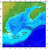 |
Figure 1. Shaded-relief image showing the extent of the 3-arcsecond digital bathymetry grid for the Gulf of Maine.
|
A digital elevation model (DEM) that combines topographic and bathymetric data into a gap-free uniform grid is useful for a variety of different purposes,
including modeling applications, visualization, and generation of regional statistics (for example, mean water depth, percent of region below a certain elevation).
In the Gulf of Maine, a 15-arcsecond (approximately 500-meter (m)) DEM created by the U.S. Geological Survey (USGS) to cover the entire region
(71°30' to 63° W, 39°30' to 46° N) has been in use for a number of years (Roworth and Signell, 1998). Since this product was developed, a large amount of new
digital data have become available, including 100-m gridded bathymetry from the Canadian Hydrographic Service, a number of high-resolution (1- to 2-m) swath
bathymetry surveys from various partners, and light detection and ranging (LIDAR)-derived topography along the coast of the United States from the
U.S. Army Corps of Engineers (USACE). It was decided, therefore, to create a new DEM to cover the same region but at 3-arcsecond resolution (approximately 90 m),
a five-fold increase in resolution compared with the previous DEM.
To generate this new DEM (fig. 1), we: obtained gridded and scattered topographic and bathymetric data from a wide
variety of sources; converted the data to a common format and datum; used a combination of automatic and manual techniques to quality control and reduce the
data onto the grid; and interpolated gaps in the grid using a surface fitting routine. In this report, we detail these processing steps.
|


