USGS - science for a changing world

FISC - St. Petersburg

Coastal & Marine Geology Program > Center for Coastal & Watershed Studies > Professional Paper 1751

Systematic Mapping of Bedrock and Habitats along the Florida Reef Tract—Central Key Largo to Halfmoon Shoal (Gulf of Mexico)

USGS Professional Paper 1751

by Barbara H. Lidz, Christopher D. Reich, and Eugene A. Shinn

Introduction:
Table of Contents
Project Overview
Project Objective
Geologic Setting
Primary Datasets
Primary Products - Overview Maps & Evolution Overview:
Bedrock Surface map.
Introduction
Depth to Pleistocene Bedrock Surface
Reef & Sediment Thickness
Benthic Ecosystems & Environments
Sedimentary Grains in 1989
Summary Illustration Index Map
Evolution Overview
Tile-by-Tile Analysis
Satellite image of the Florida Keys showing location of tiles.
Organization of Report
Tiles: 1, 2, 3, 4,
5, 6, 7/8, 9/10,
11
Summary
Acknowledg-
ments
References
Disclaimer
Related
Publications

Tile 11

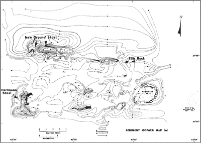
Halfmoon Shoal: Halfmoon Shoal is a bedrock high on the southwest end of the Marquesas-Quicksands ridge (Fig. 117). No cores have been drilled at Halfmoon Shoal. The shoal lies on the same trend along the south side of the ridge as the Marquesas Keys, where cores showed that Holocene sands overlie Pleistocene oolite. Scattered rock samples, collected west of the Marquesas Keys by hand, indicate that the oolite extends westward and may reach as far as Halfmoon Shoal (Shinn et al., 1990).

As elsewhere along the Florida shelf, evidence of sedimentary processes can be envisioned when sediment thickness is measured. Sand is piling up in front of rock barriers (e.g., east of Halfmoon Shoal; Fig. 135) and is accumulating in topographic lows (e.g., northwest of New Ground Shoal; Fig. 136).

Sediment isopach map of The Quicksands area
Figure 136. Sediment isopach map of The Quicksands area derived from seismic data (from Shinn et al., 1990). Note general sediment thickness of 1 to 4 m and two areas of thick accretions (bold arrows): 8 m in south-central area and 12 m at Halfmoon Shoal. Sands are migrating westward (as shown on Fig. 135). V = vibracore site. [larger version]

Coastal & Marine Geology Program > Center for Coastal & Watershed Studies > Professional Paper 1751

Accessibility FOIA Privacy Policies and Notices

Take Pride in America logo USA.gov logo U.S. Department of the Interior | U.S. Geological Survey
URL: [disc] /pubs/pp/2007/1751/professional-paper/tile11/halfmoon-shoal.html
Page Contact Information: Feedback
Page Last Modified: December 01, 2016 @ 04:13 PM (JSS)