USGS - science for a changing world

FISC - St. Petersburg

Coastal & Marine Geology Program > Center for Coastal & Watershed Studies > Professional Paper 1751

Systematic Mapping of Bedrock and Habitats along the Florida Reef Tract—Central Key Largo to Halfmoon Shoal (Gulf of Mexico)

USGS Professional Paper 1751

by Barbara H. Lidz, Christopher D. Reich, and Eugene A. Shinn

Introduction:
Table of Contents
Project Overview
Project Objective
Geologic Setting
Primary Datasets
Primary Products - Overview Maps & Evolution Overview:
Bedrock Surface map.
Introduction
Depth to Pleistocene Bedrock Surface
Reef & Sediment Thickness
Benthic Ecosystems & Environments
Sedimentary Grains in 1989
Summary Illustration Index Map
Evolution Overview
Tile-by-Tile Analysis
Satellite image of the Florida Keys showing location of tiles.
Organization of Report
Tiles: 1, 2, 3, 4,
5, 6, 7/8, 9/10,
11
Summary
Acknowledg-
ments
References
Disclaimer
Related
Publications

Tile 3

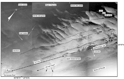
Tennessee Reef: Tennessee Reef is the only named Holocene buildup on the Pleistocene shelf-margin reef in the Tile 3 sector (Figs. 56B, 58, 67). The reef occupies an isolated bedrock high ~8 to 10 m below sea level that is surrounded by a vast sand prairie (see Benthic Ecosystems for Tile 3). Bedrock depth beneath the sand is ~10 to 14 m below sea level. It is not known whether corals became established on either side of the isolated Pleistocene reef at the time the reef began growth. If they did, they were not able to keep pace with rising sea level (e.g., Neumann and Macintyre, 1985) and are now concealed beneath sand.

Benthic Ecosystems for Tile 3
Benthic Ecosystems for Tile 3 [larger version]

Aerial photo (1975) shows seafloor morphology in vicinity of Tennessee Reef
Figure 67. Aerial photo (1975) shows seafloor morphology in vicinity of Tennessee Reef (middle Keys, Fig. 56B; from Lidz et al., 2003; compare with interpreted Benthic Ecosystems for Tile 3). 'Tripod' symbol represents location of Tennessee Reef Light. Bedrock depth below sea level on the shelf behind Tennessee Reef is similar to bedrock depth under Hawk Channel (see Bedrock Surface map). This area of the shelf margin may represent a major low-elevation bedrock connection to four of the inshore channels on either side of Lower Matecumbe Key (Figs. 57, 58). Coral-rock ridges can be traced along the shelf margin (dotted lines) and at the seaward edge of the upper-slope terrace (arrows). Ovals mark areas of patch reefs on the landward ridge. Note absence of outlier reefs on the upper-slope terrace. [larger version]

Contours of Pleistocene bedrock elevations in the Tile 3 sector indicate there may have been a significant connection from depressions beneath tidal channels in the middle Keys, across the bedrock low under Hawk Channel, to the low-elevation area surrounding Tennessee Reef. Tennessee Reef is southwest of the prominent depressions under Channels Two and Five, an unnamed channel, and Indian Key Channel on either side of Lower Matecumbe Key. These depressions may represent extensions of Pleistocene riverbeds that led from the Taylor Slough area to the shelf edge (Fig. 57; Davies, 1980; E.A. Shinn, USGS unpublished data). Region-wide contours indicate the connection, if it existed, may have been the largest in the keys (see Bedrock Surface map).

Coastal & Marine Geology Program > Center for Coastal & Watershed Studies > Professional Paper 1751

Accessibility FOIA Privacy Policies and Notices

Take Pride in America logo USA.gov logo U.S. Department of the Interior | U.S. Geological Survey
URL: [disc] /pubs/pp/2007/1751/professional-paper/tile3/tennessee-reef.html
Page Contact Information: Feedback
Page Last Modified: December 01, 2016 @ 04:13 PM (JSS)