FISC - St. Petersburg
|
Tile 3
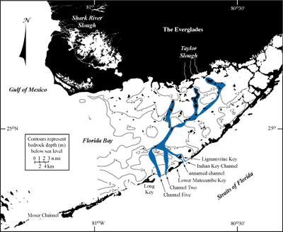
Tidal Passes and Pleistocene Riverbeds: Modern tidal passes that were once Pleistocene riverbeds (e.g., Davies, 1980; USGS, unpublished data) separate islands in the Florida Keys and connect the waters of the Everglades and Florida Bay with those of the Gulf Stream and Atlantic Ocean. What was this area like during the Pleistocene when sea level was lower and the shelf was dry land? In plan view, the southernmost tip of a peninsular highland would have terminated in a broad, shallow, half-moon-shaped depression (Florida Bay) ringed on its south edge by a discontinuous band of rocky hills (the Florida Keys) about the same height as the highland. A second, linear depression would have paralleled the band of hills on their seaward side (Hawk Channel), dividing these features from the outer part of the shelf. More bands of rock ridges, parallel to the linear depression and discontinuous but lower and narrower (the offshore coral ridge-and-swale topography, one of two primary coral reef architectures), would have ornamented the outer shelf. A tall irregular rock ridge at least 30 m high would have marked the shelf edge before the landmass sloped steeply to the upper-slope terrace, then precipitously into the ocean. Florida Bay topography consists of what has been termed a loose collection of shallow, semi-independent basins, giving it a highly irregular surface. Consisting of pelleted grainstone (classification of Dunham, 1962) or bryozoan limestone (e.g., Merriam, 1988), bay bedrock today is generally about 2 to 3 m below sea level (Fig. 57). Pelleted grainstone is composed of hardened fecal pellets and rounded skeletal grains. Bryozoa are mostly colonial calcareous marine invertebrate animals that, upon death, form cemented skeletal mounds (e.g., Multer et al., 2002). Both rock types developed during the sea-level highstand around 125 ka, at the same time the Key Largo Limestone (coral reef) and Miami Limestone (oolite) of the Florida Keys formed. Between that highstand and the subsequent (present) marine transgression, sea level remained below the elevation of all but the outermost part of the shelf (e.g., Lidz, 2004). Rivers crisscrossed the expanse of dry bay floor, draining the highland. Many were likely ephemeral, flowing only during the summer months of the rainy season.
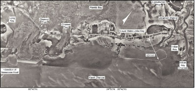
General direction of water flow during Pleistocene lowstands of sea level is believed to have been southward. Several meandering channels thought to be Pleistocene riverbeds (Davies, 1980) have been located in the floor of Florida Bay by probing to bedrock with a rod. Davies identified forked bay-floor channels south of the Taylor Slough that exit through Channel Two and Channel Five, two of the wider channels located in the tidal pass between Lower Matecumbe and Long Keys (Figs. 56B, 57, 58; see Bedrock Surface map). A third northern fork, visible on aerial photos and verified by probing, bifurcated around Lignumvitae Key in the bay, and egressed through Indian Key Channel and an unnamed channel north of Lower Matecumbe Key (Figs. 57, 58). A core taken in 1985 in the unnamed channel west of Lignumvitae Key recovered ~3 m of cross-bedded quartz sandstone overlying homogenous carbonates (USGS, unpublished data). Shallow depths of the quartz sandstone indicated sand import and emplacement had occurred during the Pleistocene. The unnamed channel was once a riverbed. Tidal channels elsewhere in the keys probably also represent bedrock depressions that once confined and carried rivers seaward. Sinuous remnants of old riverbeds are expected to exist throughout the bay floor.
In the present transgressive setting, direction of surface and groundwater flow from the Everglades is generally southward (e.g., Douglas, 1947; Porter and Porter, 2002). Two primary river systems, the Shark River Slough and the Taylor Slough, empty from the Everglades into Florida Bay (Fig. 57). The northernmost major tidal passes in the keys occur southwest of Lower Matecumbe Key in the middle Keys (Fig. 56B). Sides of the tidal channels are lined with fine-grained sediments flushed seaward from Florida Bay (Fig. 58). Water level in Florida Bay is generally higher than the level of the Atlantic Ocean most of the time (see Hydrology), which produces a net bay-to-ocean slope or gradient and a tendency for strong currents through the passes (Fig. 25A; Smith, 1994). The currents excavate sand and mud from the bay side of the keys and drop their suspended loads on the ocean side, forming lobate tidal deltas readily visible in aerial photos (Figs. 46B, 58). Tidal deltas are a prominent type of sand body in the Florida Keys (Ball, 1967). Regardless of width of a tidal pass, depth to bedrock in the middle Keys passes is estimated from field observations not to exceed ~4.5 m (Lidz et al., 2003). |

![]() U.S. Department of the Interior |
U.S. Geological Survey
U.S. Department of the Interior |
U.S. Geological Survey
URL: [disc] /pubs/pp/2007/1751/professional-paper/tile3/tidal-passes.html
Page Contact Information: Feedback
Page Last Modified: December 01, 2016 @ 04:13 PM (JSS)