FISC - St. Petersburg
|
Tile 4
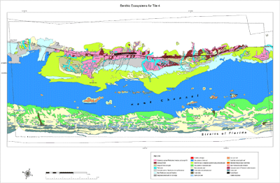
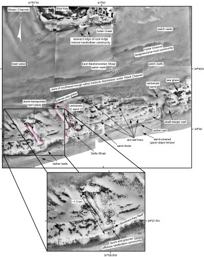
East Washerwoman Shoal and Other Patch Reefs in Hawk Channel: The bedrock depression beneath Hawk Channel varies in elevation due to clusters of patch reefs in certain areas (see Benthic Ecosystems map). The most prominent patches are named. The Mosquito Bank and Hen and Chickens patch reefs are located off the upper Keys (Benthic Ecosystems for Tile 1 and Tile 2). Patch reefs of East and West Turtle and East Washerwoman Shoals lie off the middle Keys (Figs. 68B, 75; see Benthic Ecosystems for Tile 4). West Washerwoman off the lower Keys is by far the largest mid-channel cluster of patch reefs (Benthic Ecosystems for Tile 6).
Structural control of patch-reef distribution in Hawk Channel has just recently been determined (Lidz et al., 2006). No studies, channel-wide or otherwise, have focused on why the reefs are located in the middle of the channel or why the reefs developed as isolated individual head corals or in clusters. The clusters are linear and parallel the shelf margin. The line of circular and clustered patch reefs is not aligned on any of the three well-known coral reef nuclei in Florida: an underlying beach-dune ridge, an antecedent coral reef, or lower Keys oolite of the nearshore rock ledge (Marszalek et al., 1977; Perkins, 1977; Shinn et al., 1977a, 1989; Multer et al., 2002). The discovery was serendipitous and was made when the Benthic Ecosystems map dataset was transposed onto a recent National Geophysical Data Center (NGDC; Pratson et al., 1999; Divins, 2003) bathymetric map to compare representation of the datasets. Results, clearly shown in Lidz et al. (2006), depict the so-called mid-channel patch reefs as aligning precisely along the landward edges of two topographic troughs that are found on the seaward side of and within the main bedrock depression beneath Hawk Channel. The trough edges are 10 and 6 m deep, the deeper trough being off the middle and lower Keys, consistent with platform bedrock being several meters deeper to the southwest (Enos and Perkins, 1977; Lidz et al., 2003). Benthic habitat throughout Hawk Channel consists of sea grasses on lime mud (Lidz et al. 2003). Bedrock throughout the channel depression is believed to be grainstone/wackestone, similar to that cored off north Key Largo (Shinn et al., 1994). The troughs, their inner-shelf location within Hawk Channel, and their type of limestone substrate constitute the first such new coral reef nuclei in the Florida reef record unveiled in decades. Hence, four types of substrate are now known in the Florida reef record: (a) cemented carbonate-sand beach-dune ridges; (b) antecedent coral reefs; (c) antecedent oolitic tidal bars; and (d) bedrock grainstone/wackestone troughs. For more information on the NGDC model, see http://www.ngdc.noaa.gov/mgg/coastal. Based on present knowledge and present conditions, two observable processes may also have had some influence on mid-channel patch-reef development: tidal exchange and sediment transport. Few mid-channel patch reefs are found where influx of Florida Bay water to Hawk Channel is greatest, i.e., opposite major tidal passes. More patch reefs occur opposite islands. However, the imprint of nearshore bay water on offshore reefs only became relevant during the most recent 4 to 2 ka, after a rising sea level had flooded the bay-floor depression and created the tidal passes (Figs. 41A, 57). Since it is likely that well-established patch reefs and clusters are older than 4 ka, their original formation and distribution would not have been influenced by proximity to bay waters. Sediment transport is occuring. That White Bank sediments are moving landward is well established from several lines of evidence (e.g., Ball et al., 1967; Enos and Perkins, 1977). In the lower Keys, seismic records clearly verify offshelf sediment transport. Sediment lobes are found seaward of Looe Key Reef (Lidz et al., 1985). A thick sediment wedge occurs southwest of the Marquesas Keys (Locker and Hine, 1995; see Sediment Thickness map). Backreef troughs behind the Sand Key outlier reefs are unfilled (Fig. 18), and Boca Grande Channel is basically sediment-free (Shinn et al., 1990). Finally, despite deeper bedrock to the southwest (see Bedrock Surface map), sediments average roughly the same thickness shelf-wide (~3 to 4 m; Lidz et al., 2003), indicating that offshelf transport still occurs in the lower Keys today. However, the most obvious influence derived from the habitat and NGDC map composite besides the bedrock troughs is also structural. Elevation of outer-shelf bedrock is 2 to 6 m higher than that of bedrock beneath Hawk Channel (Lidz et al., 2006). The higher outer-shelf topography traps storm-transported landward-moving outer-shelf sediment before it reaches Hawk Channel and protects the mid-channel sites from the surf zone. Branching corals prefer the surf zone. Hence, mid-channel patch reefs consist exclusively of head rather than branching corals. The largest coral clusters are found behind the highest, most protective offshore topography. |

![]() U.S. Department of the Interior |
U.S. Geological Survey
U.S. Department of the Interior |
U.S. Geological Survey
URL: [disc] /pubs/pp/2007/1751/professional-paper/tile4/east-washerwoman.html
Page Contact Information: Feedback
Page Last Modified: December 01, 2016 @ 04:14 PM (JSS)