USGS - science for a changing world

FISC - St. Petersburg

Coastal & Marine Geology Program > Center for Coastal & Watershed Studies > Professional Paper 1751

Systematic Mapping of Bedrock and Habitats along the Florida Reef Tract—Central Key Largo to Halfmoon Shoal (Gulf of Mexico)

USGS Professional Paper 1751

by Barbara H. Lidz, Christopher D. Reich, and Eugene A. Shinn

Introduction:
Table of Contents
Project Overview
Project Objective
Geologic Setting
Primary Datasets
Primary Products - Overview Maps & Evolution Overview:
Bedrock Surface map.
Introduction
Depth to Pleistocene Bedrock Surface
Reef & Sediment Thickness
Benthic Ecosystems & Environments
Sedimentary Grains in 1989
Summary Illustration Index Map
Evolution Overview
Tile-by-Tile Analysis
Satellite image of the Florida Keys showing location of tiles.
Organization of Report
Tiles: 1, 2, 3, 4,
5, 6, 7/8, 9/10,
11
Summary
Acknowledg-
ments
References
Disclaimer
Related
Publications

Tile 4

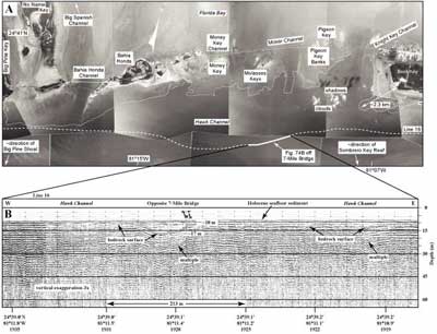
Moser Channel: The Seven Mile Bridge across Moser Channel spans the widest (~11.3 km) expanse of open water in the keys (Fig. 74A). Henry Flagler built this and all other bridges between the keys in the early 1900s as he extended the Florida East Coast Railway from Miami to Key West (e.g., Parks, 1968). The railway extension was begun in 1905, was completed in 7 years, and was destroyed by the Labor Day hurricane of 1935. Today, the Overseas Highway (US1) occupies the old bed that was cleared, filled in, and leveled for the railroad tracks.

(A) Aerial photo (1991) shows intra-island tidal channels in area of Moser Channel (lower middle Keys). (B) Section of profile along north edge of Hawk Channel shows thin sediment cover and a large depression in main bedrock low under Hawk Channel.
Figure 74. (A) Aerial photo (1991) shows intra-island tidal channels in area of Moser Channel (lower middle Keys; Fig. 68B; from Lidz et al., 2003). White dotted line marks seaward edge of a nearshore rock ledge. Note tidal-delta sediments within channels or at channel edges. Bold dashed line is 1997 seismic Line 16 along the north edge of Hawk Channel. (B) Section of profile along north edge of Hawk Channel shows thin sediment cover and a large depression in main bedrock low under Hawk Channel (from Lidz et al., 2003). Seismic line is ~4.6 km south of and opposite Seven Mile Bridge crossing Moser Channel. Bedrock beneath the bridge is ~4.5 m below sea level. Correlation of seismic profile with the photo and with a navigational chart (NOAA, 1993) indicates that the large seismic depression may be a deeper extension of the depression under Moser Channel. No seismic evidence of Knight Key Channel was visible in the part of the profile east of the section shown (along dashed line at right in A). 'Multiples' are an artifact common in seismic-reflection data. These reflections replicate those of existing, overlying, geologic surfaces and should not be regarded as representing any subsurface stratigraphic horizon. Latitude and longitude in degrees and decimal minutes based on GPS coordinates. Hours (military time) below coordinates serve as navigational correlation points along seismic line. [larger version]

A seismic profile along the north edge of Hawk Channel seaward of the Seven Mile Bridge shows a major depression cut into the channel bedrock (Fig. 74B). Surrounding bedrock is generally about 10 to 12 m below sea level and the sediment cover is thin. The low area is ~17 m deep where crossed by the seismic line and contains about 7 m of sediment. Despite the 11.3-km width of Moser Channel, field observations indicate that bedrock under most of the bridge is only about 4.5 m deep, the same depth as other, much narrower channels in the keys. In other words, channel width and channel depth are not related. Depth and location of the low area (opposite obvious channels leading from Florida Bay to Hawk Channel) strongly indicate that it may represent part of an old riverbed network, similar to that of Davies (1980; Fig. 57) that drained the Florida Bay depression when the shelf was last exposed.

Coastal & Marine Geology Program > Center for Coastal & Watershed Studies > Professional Paper 1751

Accessibility FOIA Privacy Policies and Notices

Take Pride in America logo USA.gov logo U.S. Department of the Interior | U.S. Geological Survey
URL: [disc] /pubs/pp/2007/1751/professional-paper/tile4/moser-channel.html
Page Contact Information: Feedback
Page Last Modified: December 01, 2016 @ 04:14 PM (JSS)