|
 |
 |
Primary Products - Overview Maps & Evolution Overview:
|
|
|
|
|
|
|
|
|
|
|
|
|
|
|
|
|
|
|
|
 |
|
|
|
|
|
|
|
|
|
|
|
|
|
|
|
Tile 7/8
Boca Chica Key, Key West, Fleming Key, and Urbanization: The building of Henry Flagler's East Coast Railway Key West Extension in the early 1900s profoundly affected the Florida Keys, including Boca Chica Key and Key West (Figs. 104, 105). Parks (1968) eloquently recounted the extent of the dramatic landscape alteration:
| Building the Overseas Railway, begun in 1905, put enormous stress on pristine terrestrial and nearshore environments in the keys. Among materials imported were food, water, housing and medical supplies for a work force of 3,000 to 5,000. Construction equipment included three tugs, 30 gasoline launches, 14 houseboats, eight work boats with derricks and concrete mixers, three pile drivers on floating machine shops, six dredges powered by gasoline engines, eight stern-wheel Mississippi River steamers, and more than 100 barges. A fleet of ocean-going vessels included tramp ships carrying sand, coal, crushed rock, high-grade German underwater cement, and millions of meters of pilings, reinforcing rods, steel girders, railroad track, dressed timbers, and other materials. Cofferdams and caissons placed in tidal channels allowed anchoring of viaduct supports to bedrock. Embankments, tidal creeks, canals, and channels were dammed with marl dredged from the sea floor, some from as far away as a kilometer, then lined with riprap. In less than the seven years that it took to complete the railroad from Miami to Key West, man had radically transformed unspoiled surroundings of the keys with non-native resources. |

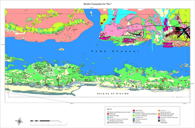
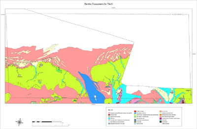
Figure 104. Aerial photo (1991) shows distinct nearshore rock ledge along seaward side of Boca Chica Key (Fig. 97C) and various ecosystem habitats (Table 2; see Benthic Ecosystems for Tile 7 and Tile 8). Hardwood and mangrove habitats dominate onshore. Patch reefs dominate an inshore hardbottom community on the rock ledge. Despite presence of airport runways built where the land was high enough to support hardwoods, this part of Boca Chica Key is not densely urbanized due to most elevations being at or near sea level. Sediments in this area are thin (~6 to 8 cm). Boca Chica Channel is cut through limestone and is maintained by dredging. [larger version] |
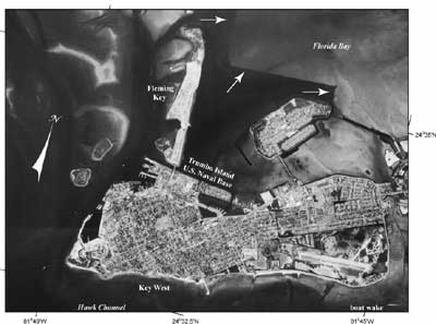
Figure 105. Key West (Fig. 97C) is one of the highest-elevation islands (~5.5 m above sea level) in the keys (Lidz and Shinn, 1991) and hence is densely urbanized. The skewed roughly rectangular area (134 acres) of Trumbo Island was constructed to house the Overseas Railroad terminal (Parks, 1968). Note three wharves at left end where train-carrying ferries docked. The ferries operated between Key West and Cuba. Also note dark area of deep water with sharp corners in Florida Bay (arrows) where marl and rock were cut and dredged by the U.S. Navy to build Fleming Key, part of the Key West Naval Base. Photo taken in 1991 by the National Ocean Service (NOAA, National Geodetic Survey). [larger version] |
The Overseas Railroad ran for 23 years before being destroyed by the Labor Day hurricane of 1935 (Parks, 1968). The eye made landfall in the vicinity of Islamorada on Upper Matecumbe Key (Fig. 97B). The highest elevation on Upper Matecumbe is less than 4 m (Lidz and Shinn, 1991); the railroad tracks at Islamorada were 2.1 m above sea level. The so-called "tidal wave" (flood surge) that inundated the island was 5.2 m high (Parks, 1968). Other accounts (e.g., Bartlette, 1997) estimate the surge was higher (up to 6 m with 3-m-high waves on top).
Years later when the U.S. Navy took possession of the abandoned Overseas Terminal on Key West, native material was removed from Florida Bay to construct the spoil island of Fleming Key. Today, Fleming Key is part of the Key West Naval Base. The cut-and-dredge area east of Fleming Key remains clearly visible from the air as a vast dark hole in the bay floor (Fig. 105; see Benthic Ecosystems for Tile 7 and Tile 8).
Good compilations of many short articles on the natural and anthropogenic history of the Florida Keys are found in Gallagher et al. (1997) and Zeiller (2005). Examples of human-interest notes are:
- Fossils and archeological finds show that prehistoric peoples shared the land south of Miami with Ice Age mammals, including dire wolves, the huge American lion, saber-toothed tigers, mastodons, mammoths, and giant ground sloths.
- The sea was much lower in prehistoric times, exposing more landmass than today, with the coastline on the Gulf Coast being 160 km farther offshore than at present. The climate was much drier, more closely resembling that of modern African savannas.
- With each rise and fall of sea level, prehistoric peoples migrated north or south in response to fluctuations in landmass size and extent, which, in turn, altered availability of fresh water, animals, and botanicals to hunt for food. Freshwater and food sources also ebbed and flowed with the sea.
- More than 1,000 shipwrecks dating to the 1500s, 1600s, and 1700s lie off the Florida Keys. Most are Spanish, but some are Dutch, British, and American. They wrecked as a result of storms or illness that disabled the crew. The best known is the Spanish galleon Nuestra Señora de Atocha, which ran aground on a calcrete-coated bedrock high on the south side of the Marquesas-Quicksands ridge in a 1622 hurricane. The bottom of the vessel remained on the sea floor at the site of impact, but the entire upper structure and treasure were scattered several kilometers to the northwest. Much of her gold, silver, and gemstone treasure is on exhibit at the Mel Fisher Maritime Heritage Society in Key West.
- The first non-native Americans settled in Key West around 1819. Key West was in the early years more closely related to Cuba than to the U.S.
- The U.S. acquired Florida from Spain in 1821.
- Key West has been home to famous writers, the most familiar being Tennessee Williams and Ernest Hemingway. Today, the Hemingway house, replete with its many well-cared-for multi-toed cats, is a historic residence, and Earnest Hemingway look-alike contests are annual events on the island.
- Key West was designated a naval station in 1823 under command of Commodore David Porter. The Key West Naval Base often hosted visits from President Harry Truman. Truman Avenue and the Truman Annex remain part of the base today.
- Industries of early settlers in the keys included cigar and salt manufacturing, rum smuggling, pirating, sailing-craft construction, sponging, agriculture, and fishing.
- "Wrecking" was also a legal profession (as well as a racket). Wreckers boated out to a stranded vessel to rescue survivors and recover cargo. The cargo was taken to a wreckers' court where a Federal judge sold the goods at auction. The captain and crew got a cut, but the U.S. Government got its share as duty on imported goods. Cargo salvage included rich French silk fabrics, Spanish shawls, European clothing, jewels, sewing machines, lumber, coal, scrap iron, bales of cotton, and casks of wine. Modern-day booty includes bales of pot.
continue to: Middle Sambo, Western Sambo, and Eastern Dry Rocks
|