|
 |
 |
Primary Products - Overview Maps & Evolution Overview:
|
|
|
|
|
|
|
|
|
|
|
|
|
|
|
|
|
|
|
|
 |
|
|
|
|
|
|
|
|
|
|
|
|
|
|
|
Tile 7/8
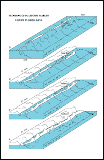
Flooding the Florida Shelf: Numerous seismic profiles across the upper and lower Keys shelf margin enabled Lidz et al. (1997b) to construct block diagrams showing general Pleistocene morphology in those areas. Those authors then superimposed a rising Holocene sea level on the diagrams to illustrate topographic and landform changes as the shelf flooded (Figs. 111, 112).
 |
|
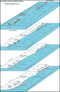 |
Figure 111. (Above left) Block diagrams of the Pleistocene shelf-edge surface off the lower Keys are constructed from outlines of pre-1997 interpreted seismic profiles (i.e., the profiles show three, not four, tracts of outlier reefs; Figs. 89, 91B; from Lidz et al., 1997b). (A-D) Diagrams show reef-and-trough system and geomorphic changes during Holocene sea-level rise. Distance between profiles is not to scale. Distance along margin between end profiles is ~65 km. Shelf-edge morphologies varied with rising sea level from long, tall, broad limestone-island ridges and shallow lagoons to low narrow islands surrounded by deep (25 m) water. Direction of wave-induced water flow was probably westward, as it is today (indicated by sediment-free troughs). Crest of shelf-edge reef on average is at or below the shelf surface, indicating lack of an offshore protective rock-island barrier when sea level was <10 m lower than present. [larger version]
Figure 112. (Above right) Block diagrams of the Pleistocene shelf-edge surface off the upper Keys are constructed from outlines of pre-1997 interpreted seismic profiles (Figs. 90, 91A; blocks at same scale as in Fig. 111; from Lidz et al., 1997b). (A-D) Diagrams show reef-and-trough system and geomorphic changes during Holocene sea-level rise. Distance between profiles is not to scale. Distance along margin between end profiles is ~10 km. Shelf-edge morphologies changed rapidly from a discontinuous series of linear, low-relief terrace islands, possibly dune ridges with wide, shallow, intervening lagoons, to no emergent features. Holocene sediments now bury the ridges and lagoonal areas. Note when sea level was 20 m lower than present (C), water filled a linear embayment formed by a backreef trough behind The Elbow, an offset reef along the emergent shelf-edge reef (Lidz et al., 1997a; see Bedrock Surface map). Also note fork in embayment (C), where margin reentrant, when flooded, would isolate the reef. Crest of shelf-edge reef is higher than the shelf, indicating presence of a rock-island barrier when sea level was <10 m below present. Note islands once existed at Grecian Rocks. [larger version] |
As rising sea level is tracked from depths of -40 m (level of the seaward edge of the upper-slope terrace) to -20 m, a few generalities can be observed.
- The lower Keys terrace area was at first defined by four widely exposed, broad, high, discontinuous rock-island ridges, then by four considerably narrower islands, all formed by the fossil outlier reefs before the outer shelf flooded (Fig. 111).
- In contrast, the upper Keys terrace area was at first defined by four low-relief, discontinuous (coral-capped dune-ridge?) islands with intervening shallow terrace lagoons, then by two narrow, reef-rock islands at the shelf edge (Fig. 112).
- When sea level was approximately 10 m below its present level, the shelf-edge reef formed a nearly unbroken island barrier. All the rock islands probably harbored fringing reefs, and all provided protection from high-energy waves generated in the Straits of Florida.
Smaller-scale changes occurred as the uneven shelf surface was inundated and the long, protective islands at the margin disappeared (summarized from Lidz and Shinn, 1991). The lower Keys shelf flooded earlier and faster than the upper Keys shelf (see Bedrock Surface map), but the upper Keys terrace topography flooded earlier and faster than the lower Keys terrace topography (Figs. 111, 112). The timing of shelf flooding implies that Holocene outer-shelf reef growth began first to the south. This scenario is supported by the ages of reefs at Looe Key (6.6 ka, Lidz et al., 1985) and at Grecian Rocks (6.0 ka, Shinn, 1980a; Fig. 92A, 92B; see Summary Illustration). As Hawk Channel became filled with water at ~6 ka, fringing reefs on the outer shelf backstepped, some by as much as several hundred meters, and increased wave action created conditions more suitable for branching elkhorn and staghorn corals than for head corals (Fig. 92B). Extensive spurs and grooves developed on windward sides of all outer-shelf and shelf-edge reefs (Fig. 113).
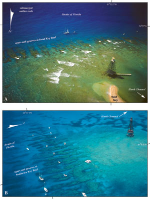
Figure 113. Photos show prominent Holocene spurs and grooves at Sand Key Reef (see aerial photo, Fig. 106B) and Sombrero Key Reef (see Fig. 75, Tile 4). The primary builder was Acropora palmata. The corals that formed the spurs are no longer alive today, but their skeletons provide substrate for colorful hardbottom communities. Neither spur-and-groove systems nor significant stands of A. palmata have been found in the Pleistocene record of Florida. [larger version] |
With continued rise in sea level, seawater invaded depressions or breaks in the inland Key Largo Limestone, eventually forming the tidal passes between the keys. The broader depressions of Florida and Biscayne Bays began to fill at ~4 ka. By ~2 ka, sea level was ~0.5 m lower than present and the Florida Keys looked much as they do today (e.g., Fig. 114). With the linking of shallow bay waters to the outer reefs, Holocene Acropora palmata and other branching-coral species that had once flourished in the spur-and-groove zones began their decline.
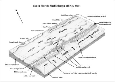
Figure 114. Conceptual block diagram shows generalized physiography and morphology in the area of the multiple outlier reefs, as based on pre-1997 knowledge of three tracts. The content, clarity, and significance of the 1975 aerial photos that clearly depict four tracts of outlier reefs were not known until the photos were sought as a part of this mapping project. [larger version] |
continue to: Addendum
|


