FISC - St. Petersburg
|
Tile 7/8
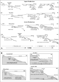
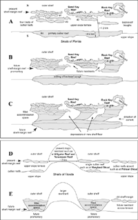
Margin Evolution: The south Florida margin is windward, facing the direction from which prevailing winds blow. The shallow, gently sloping shelf does not fit the classic model of steeply inclined, reef-rimmed windward margins (Hine and Mullins, 1983). These facts are important when examining how the Florida margin builds or progrades seaward. The Holocene surfaces seen in seismic data from the four model sites highlight, for the first time, the most striking evidence for windward-margin evolution in Florida. Holocene infilling of Pleistocene backreef troughs, where present, has extended those areas of the shelf seaward by hundreds of meters (top panels in Figs. 36A, 40A, 96A, 108A; Lidz, 2004). This type of stratigraphy can be said to characterize a backfilled prograded margin. Such processes have not occurred where reentrants are present, resulting in discontinuous or laterally alternating sites of progradation and relative stasis. Given that the outer shelf has been submerged since, roughly, only the most recent 7 ka (Table 4, Table 5), the infilling process has "stepped" the margin seaward instantaneously, relative to geologic time. Progradation over distances of several kilometers within a few thousand years is typical of highstand-shedding leeward carbonate margins (e.g., Ginsburg, 2001). Progradation by any kind of sedimentary action, especially with the rapidity evidenced in the Florida data, is not possible at classic steeply inclined windward margins (e.g., Hine and Mullins, 1983). Freestanding outlier reefs off Carysfort (Fig. 36A) and Sand Key Reefs (Fig. 108A) display keep-up profiles with the shelf-edge reef, but reef-like features seaward of the Carysfort outlier and The Elbow (Fig. 40A) show give-up (buried) profiles (Neumann and Macintyre, 1985). The outlier reefs forecast a new episode of rapid seaward-stepping progradation when their landward troughs become filled. The geologic result would be a coalesced reef-complexes margin that would manifest seismically as parallel coral facies (Figs. 36B, 108B). The coral facies would span distances of several kilometers in cross-sectional profile. Landward- and seaward-dipping bedding would again be present. Under thermal-maturation conditions, multiple-reef zones, if correctly identified over such distances, would be of high interest as potential hydrocarbon-bearing reservoirs if there were organic-rich sediments in the vicinity. Thermal-maturation conditions develop when organic deposits are buried deep beneath thick overlying strata for millions of years. Heat and pressure compress the organics, causing them to "mature" into oil and gas. In contrast, rapid progradation will likely not occur where outlier reefs are absent (Fig. 96B), or where kilometers-wide reentrants break the shelf-edge reef, such as at Alligator and Tennessee Reefs in the middle Keys (Figs. 49A, 67). The Florida windward margin thus has divergent modes of seaward expansion, at alternating sites. Under highstand conditions of sea level, the shelf edge as viewed from the air should become increasingly laterally irregular with time—at least until reentrants and the 2-km-wide accommodation space on the upper-slope terrace are filled (Figs. 109A, 109B, 110). Given stable highstand conditions, carbonate platforms will build to and just above the sea surface (e.g., Tucker, 1985). Whether there was margin progradation of any kind at any time during the Pleistocene is not known. Seismic reflections at the sites modeled indicate that highstand progradation potential did exist to the extent that backstepping Pleistocene coral reefs were slowly filling landward troughs, but time for coral growth (i.e., transgressive intervals) or rate of coral growth was insufficient, and the infill process at those sites was incomplete (Lidz, 2004).
Models of what the future geologic record might look like with continued accretion of corals and sediments at the four sites (Figs. 36B, 40B, 96B, and 108B) are summarized for easy comparison (Figs. 109A, 109B, 110). Slight differences among these drawings, such as renewed vs. non-renewed coral growth at the shelf edge or on terrace ridges, underscore the fact that we do not know precisely what type of accretions will actually accumulate at any given site in the future. |

![]() U.S. Department of the Interior |
U.S. Geological Survey
U.S. Department of the Interior |
U.S. Geological Survey
URL: [disc] /pubs/pp/2007/1751/professional-paper/tile7-8/margin-evolution.html
Page Contact Information: Feedback
Page Last Modified: December 01, 2016 @ 04:15 PM (JSS)