|
 |
 |
Primary Products - Overview Maps & Evolution Overview:
|
|
|
|
|
|
|
|
|
|
|
|
|
|
|
|
|
|
|
|
 |
|
|
|
|
|
|
|
|
|
|
|
|
|
|
|
Tile 1
Sinkhole: Florida in general is a typical karst terrain (Stringfield and LeGrand, 1966, 1971; Enos and Perkins, 1977). Chemical interaction of fresh water with limestone dissolves the limestone and forms karst (see Open-File Report 94-616). Common karst features are aquifers, sinkholes, V-shaped gullies or solution pipes, large deep underground cavities, broad flat-bottomed prairies, and closed circular depressions that either drain under ground or fill with water to become lakes (Kindinger et al., 1999, 2000). Karst features can be any size (<1 m to hundreds of meters in diameter).
A classic karst sinkhole, the only one to have been found so far on the shallow keys shelf (Shinn et al., 1996; Lidz et al., 1997a), is located off north Key Largo in 5 to 7 m of water (Figs. 22B, 27, 28). Its surface expression is a 600-m-diameter circle. The sinkhole, filled with sediment, is likely part of an underground cave system (Figs. 29, 30). Seismic profiles indicate a subsurface overhang at a depth of ~28 m below sea level but did not reveal bottom, and jet probing 55 m through sediment fill did not reach bedrock (Shinn et al., 1996). Gas-filled lime mud obscured seismic imaging below a 5-m-thick carbonate-sand cap. Bubbles encountered during coring confirmed the presence of petroliferous gas. The tendency of cores to extrude partially when brought to the surface also confirmed the presence of gas. The oldest conventional 14C age on bulk carbonate mud from the bottom of the jet probe ~60.6 m below sea level, calibrated to high-precision dating methods, yielded an age range of 6,650 to 6,280 cal. yr B.P. The youngest calibrated age range for mud just below the 5-m-thick sand cap at ~11 m below sea level is 3,250 to 2,920 cal. yr B.P. (Table 3). These ages and mud thickness indicate rapid accumulation of sediment (~50 m/3,400-3,360 yr, or about 15 m/1,000 yr), relative to 2.5 cm/1,000 yr for sediment deposition in the deep sea (Emiliani et al., 1975). Sinkholes similar to this one can be found in the Bahamas and in Mexico.
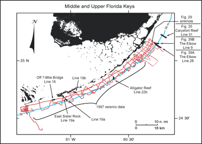
Figure 27. Index map shows USGS seismic tracklines (red) in the upper and middle Florida Keys and those portions of profile data selected (bold black) from the Tile 1 sector for illustration with their figure numbers (modified from Lidz et al., 2003; Figs. 29, 35, 39A, 39B). Shelf-margin contour (blue) is in meters. [larger version] |
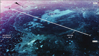
Figure 28. Oblique aerial photo looking southwest shows the large sinkhole off north Key Largo (from Shinn et al., 1996; see Fig. 27 for location). Positions of seismic-reflection profile A-A' (Fig. 29), jet-probe site, and core hole no. 2 drilled into sinkhole rim in 1991 are shown. Light areas are carbonate sand. Dark areas within sinkhole are sea grasses. Dark-crescent area at left side of sinkhole consists of algae. Maximum thickness of sinkhole sediments is not known. Distance across sinkhole is ~600 m. [larger version] |
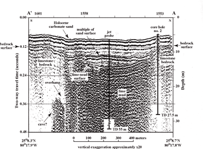
Figure 29. Seismic profile across sinkhole shows geology and sedimentology of the setting (from Shinn et al., 1996). A sediment-filled cave or overhang is present under the left (south) rim. Note opaque seismic signature in sinkhole sediments, a characteristic of gas-saturated sediments. Sediments in core hole no. 2 showed the mud is saturated with methane gas (Shinn et al., 1996). Core hole no. 2 penetrated 27.4 m of marine lime mud capped by a thin (< 5-m-thick) layer of carbonate sand. A jet probe penetrated 55 m of muddy sediment without hitting the bedrock floor. The 55-m depth is 61 m below present sea level. Latitude and longitude in degrees and decimal minutes based on GPS coordinates. Hours (military time) above ticks at top serve as navigational correlation points along seismic line. TD = total depth. [larger version] |
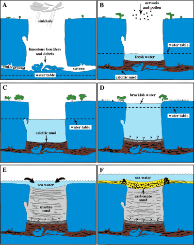
Figure 30. Model shows inferred depositional history of sediments in sinkhole (not to scale; modified from Shinn et al., 1996). (A) Sinkhole as it might have appeared ~15 ka with sea level 100 m or more below present level. Note collapsed boulders and overhang that developed above the freshwater table. (B) Sinkhole after rise of freshwater table in response to rising sea level. A shallow pond and calcite mud cover the bottom. (C) Sinkhole after continued sea-level rise. (D) Sinkhole after sea level had reached a position sufficiently high to create brackish-water conditions in the hole. Question marks indicate mud depth is unknown. (E) Initial flooding of sinkhole about 6 ka and introduction of marine-carbonate mud. (F) Sinkhole as it appears today, filled with mud and capped with carbonate sand derived from bordering coral accumulations. [larger version] |
continue to: Captain Roy's Reef
|


