USGS - science for a changing world

FISC - St. Petersburg

Coastal & Marine Geology Program > Center for Coastal & Watershed Studies > Professional Paper 1751

Systematic Mapping of Bedrock and Habitats along the Florida Reef Tract—Central Key Largo to Halfmoon Shoal (Gulf of Mexico)

USGS Professional Paper 1751

by Barbara H. Lidz, Christopher D. Reich, and Eugene A. Shinn

Introduction:
Table of Contents
Project Overview
Project Objective
Geologic Setting
Primary Datasets
Primary Products - Overview Maps & Evolution Overview:
Bedrock Surface map.
Introduction
Depth to Pleistocene Bedrock Surface
Reef & Sediment Thickness
Benthic Ecosystems & Environments
Sedimentary Grains in 1989
Summary Illustration Index Map
Evolution Overview
Tile-by-Tile Analysis
Satellite image of the Florida Keys showing location of tiles.
Organization of Report
Tiles: 1, 2, 3, 4,
5, 6, 7/8, 9/10,
11
Summary
Acknowledg-
ments
References
Disclaimer
Related
Publications

Tile 1

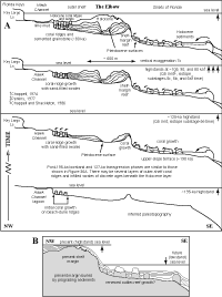
The Elbow: Two seismic profiles were used to characterize geologic features at The Elbow. One profile crossed perpendicular to the shelf margin and shows undistorted (true) images of topographic features that trend generally parallel to the margin (i.e., normal or perpendicular to the seismic line; Figs. 27, 39A). The other trackline crossed the margin at an oblique angle and shows stretched (apparent) images of features (Figs. 27, 39B). A model of margin evolution at The Elbow (Fig. 40A) was constructed from the margin-normal profile by using the method of reflection (or image) dissection that was applied at Carysfort Reef.

Model shows evolution of the shelf margin at The Elbow.Figure 40. (A) Model shows evolution of the shelf margin at The Elbow (ages >125 ka modified from Lidz, 2004). Horizontal scale and vertical exaggeration apply to features at and seaward of shelf margin based on the seismic profile that crossed normal to the margin (Fig. 39A; Lidz et al., 2003). Shelf features are based on the Marker G core transect across two coral ridges (Fig. 34A) and are not drawn to scale. Note landward expansion (dotted lines) of the Pleistocene shelf-margin reef. This type of development is called a backstepped reef complex (Lidz, 2004). Also note Holocene infilling of the backreef trough that led to a backfilled progradation of the outer shelf (Lidz, 2004). Buried outlier reefs on the upper-slope terrace are ~5-12 m high. Their crests are ~35-38 m below present sea level. Up arrows indicate six of the seven periods of sea-level highstands that produced coral reef ecosystems on the Florida shelf in the last 325 ka. Small, downward-curving arrows indicate backfilling of troughs by landward-transported sediments. Ls = limestone. ka = thousands of years. Holocene = the most recent 10 ka. Q1-Q5 Units = names assigned by Perkins (1977) to the five marine sections that compose the bedrock. Marine-isotope substages refer to periods of time that correspond to major changes in the paleotemperature record (Fig. 37A, 37B). Curved arrows indicate landward sediment transport and infilling of backreef troughs. (B) The Elbow presently exhibits a progradational-margin profile. Renewed development of outlier reefs on terrace features (white areas) would produce multiple reef complexes. When buried, the complexes would form a coalesced reef-complex margin (Lidz, 2004). [larger version]

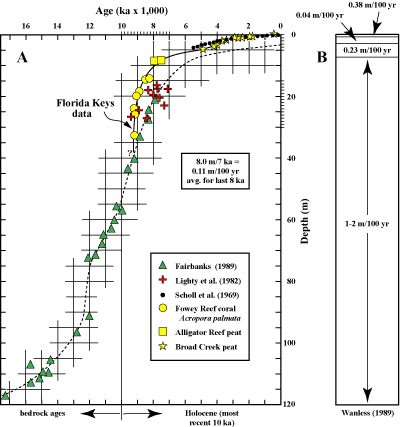
Both trackline views of The Elbow indicate that the trough behind the fossil reef has been filled with sediments. As at the Carysfort Reef area, infilling and draping surface sediments contain opposing dip directions (Fig. 40B). This result is a reminder that considering dip direction alone in the geologic record can result in misinterpretation of the direction of seaward margin accretion (Lidz, 2004).

The crest of the Pleistocene reef surface at The Elbow is ~15 m below present sea level, but the floor of the backreef trough is ~27 m deep (Fig. 39A). The crest of Holocene accretions on the bedrock reef is ~5.5 m below sea level. At its deepest point on the profile, the bedrock trough is filled with about 21.5 m of sediments. A sea-level curve derived from local dated corals, soilstone crust, and mangrove peat indicates that sea level was ~27 m lower than present at approximately 9.2 ka (Fig. 41A, 41B). Thus, filling of the trough behind The Elbow took place within the past 9,200 years or so. In contrast, the trough behind the Carysfort outlier reef 9 km to the northeast has not yet been filled (Figs. 35, 36A). In terms of geologic timescales, the trough at The Elbow has filled relatively rapidly.

Sea-level curve for the Florida reef tract. (A) Data from 8 thousand years ago to the present are considered reliable. (B) Rates of sea-level rise. Upper part of figure shows actual rise measured by tide gauges at Key West (1932-present).
Figure 41. The sea-level curve for the Florida reef tract is well constrained by local proxy data (in conventional 14C ages) as modified (Lidz and Shinn, 1991) from the curve of Robbin (1984). (A) Data from 8 ka to the present are considered reliable. (B) Rates of sea-level rise. Upper part of figure shows actual rise measured by tide gauges at Key West (1932-present). [larger version]

Coastal & Marine Geology Program > Center for Coastal & Watershed Studies > Professional Paper 1751

Accessibility FOIA Privacy Policies and Notices

Take Pride in America logo USA.gov logo U.S. Department of the Interior | U.S. Geological Survey
URL: [disc] /pubs/pp/2007/1751/professional-paper/tile1/the-elbow.html
Page Contact Information: Feedback
Page Last Modified: December 01, 2016 @ 04:13 PM (JSS)