FISC - St. Petersburg
|
Tile 1
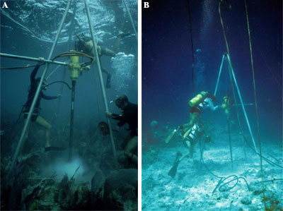
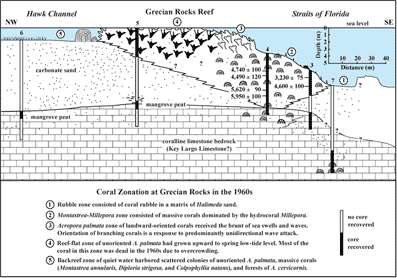
Grecian Rocks: Grecian Rocks is one of many discontinuous linear coral reefs that developed on the outer shelf landward of the current shelf margin (Fig. 22B). Coring at Grecian Rocks (Fig. 31A, 31B) has shown that coral growth began on a bedrock topographic high and that different coral species built the reef upward and landward from different depths. The result is a coral zonation (Fig. 32). Surface corals at Grecian Rocks in the 1960s showed five distinct zones (Shinn, 1963, 1980a). Field observations in 2002 revealed most of the corals including stinging corals or hydrocorals were dead. Hydrocorals (Fig. 16A, 16B, 16C, 16D) often dominate a reef when no other corals are alive (Marszalek, 1977).
The coral zones at Grecian Rocks are prime examples of the influence on corals and coral reefs of pre-existing topography and changing conditions caused by a rising sea level. During the Holocene, the 80-ka Pleistocene reef at the shelf edge formed a series of discontinuous offshore rock ridges (or linear islands) behind which topographic lows were progressively being submerged (e.g., Lidz and Shinn, 1991; see Bedrock Surface map). The ridges served as protective barriers to large waves generated by storms in the Florida Straits and provided calm waters on parts of the outer shelf. At Grecian Rocks, head corals were the early colonizers. Mangrove peat, recovered from different depths and sites at Grecian Rocks (Fig. 32), indicates that a very low-wave-energy shoreline setting existed during peat accumulation. As sea level continued to rise, the offshore Pleistocene ridges drowned, eliminating the wave barriers, moving the surf zone landward, and creating high-energy conditions suitable for branching corals. Acropora palmata was the dominant species in Holocene reefs shelf-wide.
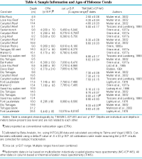
Acropora palmata was also the dominant builder of coral spurs in spur-and-groove systems. At Grecian Rocks and many other reefs, early stands of A. palmata grew in oriented fashion, forming parallel spurs normal to incoming waves. Unoriented individuals later replaced them in a landward direction (Shinn, 1980a). Changes in coral reef structure from head to branching and in coral orientation from unilateral to random indicate changing water depth and wave energy. A spur-and-groove system forms in the surf zone and acts as a buffer, deflecting wave energy. Wave energy controls coral species, orientation, and spur dimension (Shinn, 1963). Where wave energy is low, head corals become established. Where surf is constant and rough, branching corals take over and become preferentially oriented in a landward direction. In oriented growth, coral blades lean away from incoming waves; blades crosswise to waves are physically destroyed. In high-energy settings, spur-and-groove components are narrow. In lower-energy settings, such as in deeper or calmer water, branching corals form randomly oriented stands, and spur-and-groove components are wide. Spurs and grooves formed at Grecian Rocks (Shinn, 1980a) but are less obvious in deep water than similar systems on shallow shelf-margin reefs (Fig. 15). Coring has also shown that the thickest Holocene reefs developed landward of the shelf margin. Grecian Rocks, situated more than 1 km from the platform edge, is 14 m thick (Fig. 32; Shinn, 1980a). The Holocene reef at the shelf edge seaward of Grecian Rocks is less than 1 m thick (Lidz et al., 1997a). High-resolution seismic profiling and mapping confirm that, for the most part, reefs along the entire platform margin off the Florida Keys are less than 1 m thick (Lidz et al., 2003; see Sediment Thickness map). For reasons not understood, thick Holocene reefs failed to accumulate on the 80-ka Pleistocene shelf-edge reef (e.g., Toscano and Lundberg, 1998). Coral ages from various sites confirm what we know from seismic data about Pleistocene topography and Holocene flooding of the south Florida shelf. Conventional 14C ages of 6580±90 yr B.P. at the base of core LK5 at Looe Key Reef in the lower Keys (Lidz et al., 1985) and 5950±100 yr B.P. in Grecian Rocks core 4 (Shinn, 1980a) indicate Holocene coral growth began first in the lower Keys (see Summary Illustration index map). Calibrated to correlate with high-precision dates, these ages yielded growth ranges of 7,270 to 6,860 cal. yr B.P. at Looe Key and 6,610 to 6,180 cal. yr B.P. at Grecian Rocks (Table 4). The older Looe Key range is consistent with lower bedrock elevation and thus earlier flooding in the lower than upper Keys (see Bedrock Surface map).
|

![]() U.S. Department of the Interior |
U.S. Geological Survey
U.S. Department of the Interior |
U.S. Geological Survey
URL: [disc] /pubs/pp/2007/1751/professional-paper/tile1/grecian-rocks.html
Page Contact Information: Feedback
Page Last Modified: December 01, 2016 @ 04:12 PM (JSS)