Data Series 294

Appendix for U.S. Geological Survey Data Series 294

2007


Monitoring the Storm Tide of Hurricane Wilma in Southwestern Florida, October 2005

Lars E. Soderqvist and Michael J. Byrne


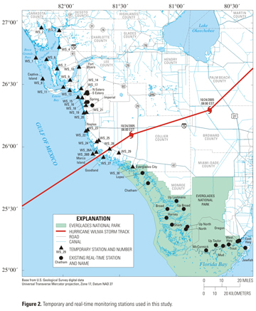
Appendix 1. Hurricane Wilma Storm-Tide Data Files, October 2005

All data collected for this study from the temporary stations are presented as text files. All temporary stations recorded 30-second data. Data presented include date and time, water-level and barometric sensor pressure in pounds per square inch (PSI), arbitrary water elevation in feet, storm-tide water elevation in feet relative to NAVD 88, and lowest recordable water elevation in feet relative to NAVD 88. The lowest recordable water elevation was set to 0.05 ft above the elevation of the water-level sensor. Also presented are all data used to adjust pressure data from inundated sensors to storm-tide elevation above NAVD 88. All data collected for this study from the real-time permanent stations are also presented. Permanent (real-time) stations recorded 15-minute data. Data presented includes date and time, and storm-tide water elevation relative to NAVD 88. Data was pulled from the USGS database as computed unit-value data. Time-series graphs for all stations presented in this report (temporary and real-time) are also presented.

Units of measure:

Water-level Pressure: PSI, pounds per square inch
Barometric Pressure: PSI, pounds per square inch
Arbitrary Elevation: ft, feet
Storm-tide Elevation: ft, feet (relative to North American Vertical Datum of 1988)
Lowest Recordable Elevation: ft, feet (relative to North American Vertical Datum of 1988)


Return to report home page

Figure 2

REAL-TIME STATIONS    
Broad River; .xls, .txt
Chatham River; .xls, .txt
East Highway Creek; .xls, .txt
Harney River; .xls, .txt
Imperial River; .xls, .txt
Jewfish Creek; .xls, .txt
Lopez River; .xls, .txt
McCormick Creek; .xls, .txt
Mud Creek; .xls, .txt
North Branch Estero River; .xls, .txt
North River; .xls, .txt
Oregon Creek; .xls, .txt
Shark River; .xls, .txt
South Branch Estero River; .xls, .txt
Spring Creek; .xls, .txt
Trout Creek; .xls, .txt
Upstream Broad River; .xls, .txt
Upstream Lostmans River; .xls, .txt
Upstream North River; .xls, .txt
Upstream Taylor River; .xls, .txt
West Highway Creek; .xls, .txt
TEMPORARY STATIONS    
WS_1 Charlotte Harbor at Boca Grande Pass; .xls, .txt
WS_2 Myakka River at El Jobean; .xls, .txt
WS_3 Peace River at Punta Gorda; .xls, .txt
WS_4 Charlotte Harbor at Pirate Harbor; .xls, .txt
WS_6 Charlotte Harbor at Bokeelia; .xls, .txt
WS_7 Matlacha Pass at SR-78; .xls, .txt
WS_8 Captiva Island at South Seas Resort; .xls, .txt
WS_9 Caloosahatchee River at Redfish Point; .xls, .txt
WS_10 Downtown Fort Myers Yacht Basin; .xls, .txt
WS_11 Punta Rassa at boat ramp; .xls, .txt
WS_12 Fort Myers Beach pier; .xls, .txt
WS_13 Matanzas Pass bridge; .xls, .txt
WS_14 Mullock Creek at marina; .xls, .txt
WS_15 Big Carlos Pass; .xls, .txt
WS_16 Estero Bay at Coconut Point; .xls, .txt
WS_17 Estero River at US-41; .xls, .txt
WS_18 Spring Creek at US-41; .xls, .txt
WS_19 Imperial River at US-41; .xls, .txt
WS_20 Wiggins Pass State Park; .xls, .txt
WS_21 Cocahatchee River at US-41; .xls, .txt
WS_22 Naples Pier; .xls, .txt
WS_23 Naples Bay at US-41 Gordon River bridge; .xls, .txt
WS_24 Henderson Creek (downstream) at KOA ramp; .xls, .txt
WS_25 Henderson Creek at US-41; .xls, .txt
WS_26A Marco Island (bayside) at MIYC; .xls, .txt
WS_26B Marco Island (gulfside) at Tigertail Beach; .xls, .txt
WS_27 Goodland; .xls, .txt
WS_28 Blackwater River at boat basin; .xls, .txt
WS_29 Faka Union Canal; .xls, .txt
WS_30 Everglades City at ranger station; .xls, .txt


For additional information, contact:

U.S. Department of the Interior
U.S. Geological Survey
Florida Water Science Center
1400 Colonial Blvd., Suite 70
Ft. Myers, Fl 33907
239-275-8448

lsoderq@usgs.gov


Accessibility FOIA Privacy Policies and Notices
U.S. Department of the Interior, U.S. Geological Survey
Persistent URL: https://pubs.usgs.gov/ds/2007/294/appendix.html
Page Contact Information: USGS Publishing Network
Page Last Modified: Monday, 28-Nov-2016 12:31:33 EST

FirstGov button  Take Pride in America button