FISC - St. Petersburg
|
Tile 6
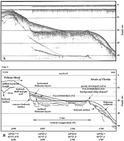
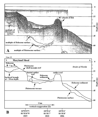
American, Maryland, and Pelican Shoals: A group of five nearly equidistant Holocene shelf-edge reefs occupies the margin off Sugarloaf, Saddlebunch, and Boca Chica Keys (Figs. 86C, 91B). American, Maryland, and Pelican Shoals are within ~20 km of Looe Key Reef (Fig. 87A, 87B). Like Looe Key Reef, the three shoals have spurs and grooves, but they are less developed than at Looe Key Reef (Fig. 88). Eastern and Western Sambo are the two western reefs in the group. Eastern Sambo falls at the left edge of the Tile 6 sector (Fig. 86C). Data from seismic profiles across the shelf margin in the upper and lower Keys (Figs. 89, 90, 91A, 91B) show both consistent and contrasting overall morphologies (Lidz et al., 1997a). Common to both areas is the presence of a discontinuous shelf-margin reef fronted by a seaward upper-slope terrace ranging in depth from 30 to 40 m below present sea level. Terrace sediments margin-wide average 3 to 4 m thick (see Sediment Thickness map). Contrasts are more numerous. For example:
The Tile 6 terrace surface near American, Maryland, and Pelican Shoals shows variations ranging from a generally non-descript low-gradient slope, to a horizontal surface, to a 'corrugated' or karstified surface that supports outlier reefs at the seaward edge (Fig. 89, left column). Structures on the terrace vary in relief, ranging from a slightly elevated reef-flat-like feature (Fig. 89, line 12) to a buried dune-ridge feature (line 3) to prominent outlier reefs that are both buried and exposed (lines 4 and 2). Number of outlier-reef tracts ranges from zero at Pelican Shoal (Fig. 94), to one at Eastern Sambo (Fig. 89, line 2), to two at Maryland Shoal (Fig. 95), to three and four tracts off Rock Key and Sand Key Reefs (Figs. 18, 89, lines 16a-d, 17, 18, and Tile 7/8). Like the shelf-edge reef, the outlier tracts are discontinuous.
The relatively uncomplicated seismic record at Pelican Shoal may be representative of general shelf-edge morphology before development of outlier reefs on the terrace. Lidz et al. (2003) used the Pelican Shoal profile (Fig. 94A) as the generic basis for models to reconstruct shelf-margin evolution at Carysfort Reef (Fig. 36A), The Elbow (Fig. 40A), Pelican Shoal (Fig. 96A), and Sand Key Reef (Tile 7/8). These areas were selected for modeling based on presence of the discontinuous shelf-edge reef, the amount of coral-age data available, and the variability in seismic data. The seismic data as illustrated in the models indicate that these areas consist primarily of two coral reef architectures: a ridge-and-swale structure on the shelf, and a reef-and-trough structure at the margin.
Based on coring and commercial-excavation data at local sites (e.g., Shinn et al., 1977a), Lidz et al. (2003) theorized that cemented sand dunes most likely provided elevated sediment-free nuclei for initial coral growth on the shelf and terrace. Pleistocene sand dunes are widespread in the Bahamas and Caribbean, where present environmental setting is similar to that in Florida (Ball, 1967; McKee and Ward, 1983), indicating that dunes should be present region-wide in the Florida Pleistocene as well. Locker et al. (1996) have documented ~14-ka beach-dune and paleoshoreline complexes that parallel the shelf margin between 124 and 50 m below present sea level. At that time, the present marine transgression was underway.
Prior to 14-ka, however, the Florida shelf had already been subaerially exposed for ~54 ka (68 ka minus the 14-ka age of the paleoshoreline complexes), providing ample time for beach dunes to form (see Bands of Outer-Shelf Coral-Rock Ridges section; Lidz, 2004). Beach dunes develop under conditions of subaerial exposure, abundant sand availability, low rainfall, and high capability of sand mobilization. Such conditions likely existed on the vast reaches of a pre-Florida platform exposed by low stands of Pleistocene sea level. Lidz et al. (2003) inferred that the most recent opportunity for formation of sand dunes beneath the outer-shelf reefs and upper-slope terrace outlier reefs was around 175 ka. That time estimate was derived from seismic, core, aerial photomosaic, and high-precision radiometric-age data correlated with maximum elevations of global sea levels over the past 325 ka (Fig. 37). Later correlation, however, with a well-accepted marine oxygen-isotope paleotemperature curve (Fig. 80A) showed that sea level at 180 ka was below the Florida shelf. The latest possible time of terrace formation was therefore more likely around 190 ka, after a highstand at ~195 ka (Lidz, 2006). That high sea-level stand was the last Pleistocene sea level to exceed present terrace depths (30-40 m) and to precede the well-dated outlier reefs (Table 6). Models of shelf evolution were constructed primarily on the basis of: (a) building incremental, dated (where available) components of geologic strata as they appear in seismic profiles of the shelf margin, correlated with periods of sea level high enough to have flooded the shelf (Table 6 and Table 7); and (b) knowledge of the shelf-wide coral-rock ridges on the outer shelf. Ridge data were gleaned from field observation, aerial-photographic evidence (for example, as seen in Figs. 33A, 33B, 87A, 87B), and the cores recovered at Marker G (Fig. 34A).
The bedrock image or reflection visible in the seismic record off Pelican Shoal shows a broad, flat, upper-slope terrace fronting the Pleistocene shelf-margin reef (Fig. 94A, 94B). To construct the evolutionary model for the Carysfort, The Elbow, and Sand Key Reef areas, a 'generic' Pelican Shoal surface was modified to approximate seismic bedrock reflections in those areas (Figs. 36A, 40A, bottom panels, and Tile 7/8). Then, using the reflection representing the bedrock surface as traced from the seismic profiles, 'layers' simulating bedrock coral growth were added between the terrace and reef surfaces. Each layer was correlated with coral dates from the shelf-margin reef and the outlier reef (Figs. 36A, 40A, top panels, and Tile 7/8) and with stands of interglacial sea levels that were sufficiently high to have flooded the shelf (Fig. 37). Lastly, except at the crest of Carysfort Reef where the water is too shallow to obtain seismic data, the Holocene component was drawn as traced from the seismic profiles. The model for Pelican Shoal was constructed in the same fashion (Fig. 96A). The Holocene component at Carysfort Reef was drawn from field knowledge. Lidz (2004) proposed terminology for application to platform margins in general to characterize the various stratigraphies observed in the Florida Keys seismic data.
With continued sediment accretion and no development of outlier reefs at Pelican Shoal, future seismic images of this and similar areas of the margin would represent a classic prograded margin (Fig. 96B), or one that had advanced seaward by spilling of sands over the shelf edge. Progradation is the seaward advance or building of the shelf and margin by deposition and accumulation of sediments derived from the shelf. A geologic process, progradation can be rapid in terms of geologic time. The western margins of the Great Bahama Bank (e.g., Ginsburg, 2001) and Little Bahama Bank (Hine and Neumann, 1977) are classic examples of prograded margins. In Florida, progradation occurred as Holocene reefs and sediments filled bedrock troughs behind many areas of the Pleistocene shelf-edge reef, such as at Maryland and Pelican Shoals (Figs. 95B, 96A). Other examples can be seen elsewhere in the profiles of margin morphology (Figs. 89, 90). The progradational process is presently occurring in front of the shelf-edge reef through sand chutes, which are low-elevation areas or breaks (sometimes called divides, Fig. 92A) in the shelf-edge reef through which sands sift slowly off the shelf due to tidal and current action. Sand chutes are present everywhere along the shelf edge (good examples can be seen in Figs. 33A, 33B, 48B, 75, 87A). In the case of the Florida windward margin, chute sediments would accumulate first on the upper-slope terrace before cascading over the seaward edge to greater depths. The seismic and coral-age data document that where progradation occurred on the Florida margin, it was very rapid relative to geologic time, having taken place only after the shelf became flooded about 7 ka. Whether progradation occurred in the Pleistocene is not known. However, the models indicate that the potential had existed. Backstepping Pleistocene coral growth partially filled landward troughs (e.g., Figs. 36A, 40A, 96A). If the duration of highstand intervals and coral-growth phases had been longer, the troughs might eventually have become filled (Lidz, 2004). One of the most significant outcomes of the Lidz (2004) models was the formal recognition that alternating sections of the Florida windward margin had prograded during the Holocene. Most reef-rimmed windward margins in the geologic record are steeply inclined and are regarded as aggraded. Aggradation is the building upward and seaward of the shelf and margin by the deposition and accretion of skeletal calcium-carbonate organisms such as reefs of coral. As opposed to the rapid (relative to geologic time) geologic process of progradation, aggradation is a slow biologic process. |

![]() U.S. Department of the Interior |
U.S. Geological Survey
U.S. Department of the Interior |
U.S. Geological Survey
URL: [disc] /pubs/pp/2007/1751/professional-paper/tile6/american-shoals.html
Page Contact Information: Feedback
Page Last Modified: December 01, 2016 @ 04:14 PM (JSS)